Property Record
Towpath Ln E, Fort Edward, NY 12828
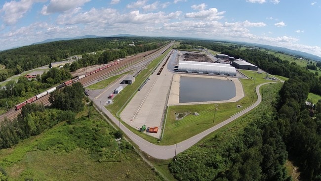
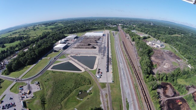
Property Detail
Towpath Ln E
533001-163-015-0001-004-000-0000
WASHINGTON
Warehouse
New York
M1
20.001
2025
27.88 AC
2025
Washington County
080301
Albany/Schenectady/Troy
2,400 SF
Glens Falls, NY
NEARBY LISTINGS FOR SALE OR LEASE
DEMOGRAPHICS near Towpath Ln E
1 mile
3 mile
5 mile
2025 Total Population
2,049
16,009
40,233
2030 Population
2,036
15,914
39,913
Pop Growth 2025-2030
(0.63%)
(0.59%)
(0.80%)
Average Age
42
41
42
2025 Total Households
877
6,671
17,432
HH Growth 2025-2030
(0.80%)
(0.70%)
(0.88%)
Median Household Inc
$65,094
$67,845
$69,913
Avg Household Size
2.30
2.30
2.20
2025 Avg HH Vehicles
2.00
2.00
2.00
Median Home Value
$160,862
$170,612
$203,770
Median Year Built
1948
1955
1958
Nearby Places
Map Layers
Map Styles
 Street
 Aerial
Layers
 Traffic
 Biking
Places
Listings with unknown addresses are not visible on the map
- Restaurants
- Banks
- Shops
- Fitness
- Groceries
SALE & LEASE HISTORY
LISTING DATE
SALE/LEASE

May 18, 2023
For Sale
Nearby Properties
Address
Land Use
TOTAL SIZE
Lot Size
Zoning
Address
Land Use
TOTAL SIZE
Lot Size
Zoning
16.34 AC
M1
Address
Land Use
TOTAL SIZE
Lot Size
Zoning
116,696 SF
23.70 AC
04 - FARM
Address
Land Use
TOTAL SIZE
Lot Size
Zoning
393,880 SF
23.90 AC
M1
Address
Land Use
TOTAL SIZE
Lot Size
Zoning
9,216 SF
32.20 AC
UR
Address
Land Use
TOTAL SIZE
Lot Size
Zoning
5,680 SF
39.79 AC
UR
Address
Land Use
TOTAL SIZE
Lot Size
Zoning
82,922 SF
8.03 AC
I
Address
Land Use
TOTAL SIZE
Lot Size
Zoning
Address
Land Use
TOTAL SIZE
Lot Size
Zoning
113.40 AC
04 - FARM
Address
Land Use
TOTAL SIZE
Lot Size
Zoning
89,902 SF
9.61 AC
05 - COMME
Address
Land Use
TOTAL SIZE
Lot Size
Zoning
6,549 SF
17.26 AC
M1
Address
Land Use
TOTAL SIZE
Lot Size
Zoning
3,000 SF
14.95 AC
M1
Address
Land Use
TOTAL SIZE
Lot Size
Zoning
119,455 SF
66.60 AC
LDR25
Address
Land Use
TOTAL SIZE
Lot Size
Zoning
42,156 SF
5.93 AC
05 - COMME
Address
Land Use
TOTAL SIZE
Lot Size
Zoning
134,998 SF
19.30 AC
05 - COMME
Address
Land Use
TOTAL SIZE
Lot Size
Zoning
141,480 SF
29.05 AC
RA
Address
Land Use
TOTAL SIZE
Lot Size
Zoning
56,884 SF
8.73 AC
R2
Address
Land Use
TOTAL SIZE
Lot Size
Zoning
106,209 SF
6.22 AC
M1
Address
Land Use
TOTAL SIZE
Lot Size
Zoning
41,280 SF
50.96 AC
M1
Address
Land Use
TOTAL SIZE
Lot Size
Zoning
Address
Land Use
TOTAL SIZE
Lot Size
Zoning
4,715 SF
43.55 AC
RP
Address
Land Use
TOTAL SIZE
Lot Size
Zoning
44,817 SF
2.75 AC
PUD
Address
Land Use
TOTAL SIZE
Lot Size
Zoning
75,156 SF
2.78 AC
RA
Address
Land Use
TOTAL SIZE
Lot Size
Zoning
4,200 SF
9.99 AC
LDR25
Address
Land Use
TOTAL SIZE
Lot Size
Zoning
Address
Land Use
TOTAL SIZE
Lot Size
Zoning
131,704 SF
3.19 AC
M1
Address
Land Use
TOTAL SIZE
Lot Size
Zoning
69,290 SF
1.84 AC
C
Address
Land Use
TOTAL SIZE
Lot Size
Zoning
8,348 SF
13.60 AC
UR
Address
Land Use
TOTAL SIZE
Lot Size
Zoning
68,565 SF
25.85 AC
LDR25
Address
Land Use
TOTAL SIZE
Lot Size
Zoning
55,979 SF
6.76 AC
06 - INDUS
The World's #1 Commercial Real Estate Marketplace
Connect with us
© 2026 CoStar Group
The information above has been obtained from sources believed reliable. While we do not doubt its accuracy we have not verified it and make no guarantee, warranty or representation about it. It is your responsibility to independently confirm its accuracy and completeness. Any projections, opinions, assumptions, or estimates used are for example only and do not represent the current or future performance of the property. The value of this transaction to you depends on tax and other factors which should be evaluated by your tax, financial, and legal advisors. You and your advisors should conduct a careful, independent investigation of the property to determine to your satisfaction the suitability of the property for your needs.