Property Record
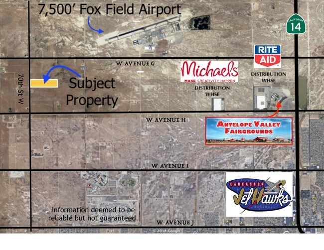
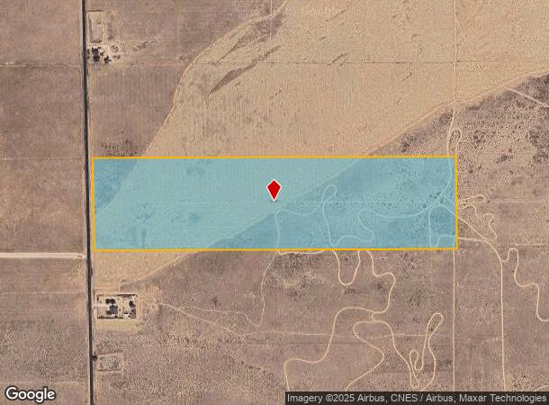
Vac/70Th Stw Vic Ave W, Lancaster, CA 93536


NEARBY LISTINGS FOR SALE OR LEASE
Property Detail
Vac/70Th Stw Vic Ave W
3268-015-004
39.54 MORE OR LESS ACS BEING EX OF ST S 1/2 OF LOT 1 IN NW 1/4 OF SEC 3 T 7N R 13W
Industrialacreage
Los Angeles
X
California
06037C0400F
1
2024
39.40 AC
2025
Antelope Valley
901214
Los Angeles
1,472 SF
Los Angeles-Long Beach-Glendale, CA
DEMOGRAPHICS near Vac/70Th Stw Vic Ave W
1 Mile
3 Mile
5 Mile
2024 Total Population
72
3,920
32,950
2029 Population
75
3,929
32,210
Pop Growth 2024-2029
+ 4.17%
+ 0.23%
(2.25%)
Average Age
41
38
37
2024 Total Households
23
1,190
9,971
HH Growth 2024-2029
+ 4.35%
+ 0.08%
(2.52%)
Median Household Inc
$110,000
$98,377
$101,406
Avg Household Size
3.00
3.20
3.20
2024 Avg HH Vehicles
2.00
2.00
2.00
Median Home Value
$299,999
$391,731
$423,982
Median Year Built
1986
1998
1998
Nearby Places
Map Layers
Map Styles
 Street
 Aerial
- Restaurants
- Banks
- Shops
- Fitness
- Groceries
PUBLIC TRANSPORTATION
COMMUTER RAIL
Lancaster (Antelope Valley Line - Southern California Regional Rail Authority (Metrolink))
DRIVE
WALK
Distance
Lancaster (Antelope Valley Line - Southern California Regional Rail Authority (Metrolink))
14 min
8.7 mi
Freight Ports
Port of Long Beach
DRIVE
WALK
Distance
Port of Long Beach
118 min
101.2 mi
SALE & LEASE HISTORY
LISTING DATE
SALE/LEASE

May 08, 2024
For Sale
Aug 08, 2019
For Sale
Nearby Properties
Address
Land Use
TOTAL SIZE
Lot Size
Zoning
Address
Land Use
TOTAL SIZE
Lot Size
Zoning
249,045 SF
19.74 AC
LRMPD*
Address
Land Use
TOTAL SIZE
Lot Size
Zoning
0.34 AC
LCA22*
Address
Land Use
TOTAL SIZE
Lot Size
Zoning
32.02 AC
LRSP
Address
Land Use
TOTAL SIZE
Lot Size
Zoning
Address
Land Use
TOTAL SIZE
Lot Size
Zoning
109.81 AC
LRR1
Address
Land Use
TOTAL SIZE
Lot Size
Zoning
14,581 SF
0.95 AC
LRSP*
Address
Land Use
TOTAL SIZE
Lot Size
Zoning
75.22 AC
LRR1
Address
Land Use
TOTAL SIZE
Lot Size
Zoning
76.91 AC
LRA12*
Address
Land Use
TOTAL SIZE
Lot Size
Zoning
80 AC
LRA12*
Address
Land Use
TOTAL SIZE
Lot Size
Zoning
1,192 SF
39.98 AC
LRR1-7000
Address
Land Use
TOTAL SIZE
Lot Size
Zoning
14,581 SF
1.06 AC
LRSP*
Address
Land Use
TOTAL SIZE
Lot Size
Zoning
56.02 AC
LRRR-2.5
Address
Land Use
TOTAL SIZE
Lot Size
Zoning
75.90 AC
LRRR-2.5
Address
Land Use
TOTAL SIZE
Lot Size
Zoning
116.93 AC
LRRR
Address
Land Use
TOTAL SIZE
Lot Size
Zoning
37.72 AC
LRRR-2.5
Address
Land Use
TOTAL SIZE
Lot Size
Zoning
11,558 SF
3.81 AC
LCC4-A11*
Address
Land Use
TOTAL SIZE
Lot Size
Zoning
37.01 AC
LRA12*
Address
Land Use
TOTAL SIZE
Lot Size
Zoning
153.67 AC
LRRR25*
Address
Land Use
TOTAL SIZE
Lot Size
Zoning
7,858 SF
0.60 AC
LRSP*
Address
Land Use
TOTAL SIZE
Lot Size
Zoning
7,798 SF
1.13 AC
LCC4*
Address
Land Use
TOTAL SIZE
Lot Size
Zoning
6,800 SF
0.78 AC
LCC4*
Address
Land Use
TOTAL SIZE
Lot Size
Zoning
16,614 SF
1.09 AC
LRSP*
Address
Land Use
TOTAL SIZE
Lot Size
Zoning
22.02 AC
LRPK
Address
Land Use
TOTAL SIZE
Lot Size
Zoning
7,925 SF
9.55 AC
LCC1-A22*
Address
Land Use
TOTAL SIZE
Lot Size
Zoning
6,370 SF
0.54 AC
LRSP*
Address
Land Use
TOTAL SIZE
Lot Size
Zoning
2,176 SF
79.23 AC
LCA21*
Address
Land Use
TOTAL SIZE
Lot Size
Zoning
7,858 SF
0.61 AC
LRSP*
Address
Land Use
TOTAL SIZE
Lot Size
Zoning
7,858 SF
0.54 AC
LRSP*
Address
Land Use
TOTAL SIZE
Lot Size
Zoning
2,992 SF
306.49 AC
LCA21*
Address
Land Use
TOTAL SIZE
Lot Size
Zoning
2,710 SF
2.39 AC
LCC4-A11*
The World's #1 Commercial Real Estate Marketplace
Connect with us
© 2025 CoStar Group
The information above has been obtained from sources believed reliable. While we do not doubt its accuracy we have not verified it and make no guarantee, warranty or representation about it. It is your responsibility to independently confirm its accuracy and completeness. Any projections, opinions, assumptions, or estimates used are for example only and do not represent the current or future performance of the property. The value of this transaction to you depends on tax and other factors which should be evaluated by your tax, financial, and legal advisors. You and your advisors should conduct a careful, independent investigation of the property to determine to your satisfaction the suitability of the property for your needs.