Property Record
Valley Rd, Bernards, NJ 07920
Save to a Folder
{{folder.Name}}
{{folder.ListingIds.length}} Properties
{{folder.ListingIds.length}} Property
Create a New Folder
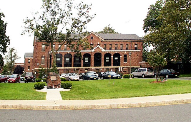
Property Detail
Valley Rd
Lakewood-New Brunswick, NJ
FACILITY NAME: HOSPITAL
02-08001-0000-00003
SOMERSET
Governmentalpublicusegeneral
New Jersey
P4
3
B and X Area of moderate flood hazard, usually the area between the limits of the 100-year and 500-year floods.
155.97 AC
0
Route 78 East
2026
Northern New Jersey
054100
NEARBY LISTINGS FOR SALE OR LEASE
DEMOGRAPHICS near Valley Rd
1 mile
3 mile
5 mile
2025 Total Population
5,982
29,272
74,272
2030 Population
6,193
30,346
77,028
Pop Growth 2025-2030
+ 3.53%
+ 3.67%
+ 3.71%
Average Age
44
43
43
2025 Total Households
2,185
10,836
27,809
HH Growth 2025-2030
+ 3.71%
+ 3.89%
+ 3.87%
Median Household Inc
$175,522
$182,476
$180,509
Avg Household Size
2.50
2.60
2.60
2025 Avg HH Vehicles
2.00
2.00
2.00
Median Home Value
$656,188
$791,162
$784,719
Median Year Built
1983
1982
1983
Nearby Places
Map Layers
Map Styles
 Street
 Aerial
Layers
 Traffic
 Biking
Places
Listings with unknown addresses are not visible on the map
- Restaurants
- Banks
- Shops
- Fitness
- Groceries
PUBLIC TRANSPORTATION
COMMUTER RAIL
Lyons (Morris & Essex Gladstone Branch - NJ Transit Commuter Rail (NJ Transit))
Drive
Walk
Distance
Lyons (Morris & Essex Gladstone Branch - NJ Transit Commuter Rail (NJ Transit))
6 min
1.5 mi
Millington (Morris & Essex Gladstone Branch - NJ Transit Commuter Rail (NJ Transit))
Drive
Walk
Distance
Millington (Morris & Essex Gladstone Branch - NJ Transit Commuter Rail (NJ Transit))
10 min
3.4 mi
AIRPORT
Newark Liberty International
Drive
Walk
Distance
Newark Liberty International
36 min
26.1 mi
Freight Ports
New York Container Terminal
Drive
Walk
Distance
New York Container Terminal
46 min
29.0 mi
Nearby Properties
Address
Land Use
TOTAL SIZE
Lot Size
Zoning
Address
Land Use
TOTAL SIZE
Lot Size
Zoning
52.31 AC
OR
Address
Land Use
TOTAL SIZE
Lot Size
Zoning
294,624 SF
56.79 AC
R2
Address
Land Use
TOTAL SIZE
Lot Size
Zoning
8.64 AC
AH-4
Address
Land Use
TOTAL SIZE
Lot Size
Zoning
206,077 SF
22.03 AC
B5
Address
Land Use
TOTAL SIZE
Lot Size
Zoning
290,000 SF
51.96 AC
E4
Address
Land Use
TOTAL SIZE
Lot Size
Zoning
141.44 AC
P4
Address
Land Use
TOTAL SIZE
Lot Size
Zoning
85,000 SF
25.62 AC
E3
Address
Land Use
TOTAL SIZE
Lot Size
Zoning
46.96 AC
OR
Address
Land Use
TOTAL SIZE
Lot Size
Zoning
839.97 AC
P1
Address
Land Use
TOTAL SIZE
Lot Size
Zoning
15 AC
R2
Address
Land Use
TOTAL SIZE
Lot Size
Zoning
115.79 AC
OR
Address
Land Use
TOTAL SIZE
Lot Size
Zoning
34.78 AC
P3
Address
Land Use
TOTAL SIZE
Lot Size
Zoning
21,500 SF
9.66 AC
E4
Address
Land Use
TOTAL SIZE
Lot Size
Zoning
68,160 SF
11.66 AC
R6
Address
Land Use
TOTAL SIZE
Lot Size
Zoning
25.64 AC
E2
Address
Land Use
TOTAL SIZE
Lot Size
Zoning
1,096 SF
15.12 AC
R5
Address
Land Use
TOTAL SIZE
Lot Size
Zoning
126,360 SF
36.03 AC
E3
Address
Land Use
TOTAL SIZE
Lot Size
Zoning
40.36 AC
OR
Address
Land Use
TOTAL SIZE
Lot Size
Zoning
30.84 AC
OR
Address
Land Use
TOTAL SIZE
Lot Size
Zoning
61,059 SF
9.10 AC
R6
Address
Land Use
TOTAL SIZE
Lot Size
Zoning
1,428 SF
19.52 AC
E2
Address
Land Use
TOTAL SIZE
Lot Size
Zoning
40.73 AC
OR
Address
Land Use
TOTAL SIZE
Lot Size
Zoning
15.22 AC
OR
Address
Land Use
TOTAL SIZE
Lot Size
Zoning
13.07 AC
OR
Address
Land Use
TOTAL SIZE
Lot Size
Zoning
62,250 SF
14.43 AC
E2
Address
Land Use
TOTAL SIZE
Lot Size
Zoning
2,976 SF
19.80 AC
SH2
Address
Land Use
TOTAL SIZE
Lot Size
Zoning
93,035 SF
41.85 AC
R1
Address
Land Use
TOTAL SIZE
Lot Size
Zoning
5.71 AC
OR
Address
Land Use
TOTAL SIZE
Lot Size
Zoning
34.61 AC
E3
The World's #1 Commercial Real Estate Marketplace
Connect with us
© 2026 CoStar Group
The information above has been obtained from sources believed reliable. While we do not doubt its accuracy we have not verified it and make no guarantee, warranty or representation about it. It is your responsibility to independently confirm its accuracy and completeness. Any projections, opinions, assumptions, or estimates used are for example only and do not represent the current or future performance of the property. The value of this transaction to you depends on tax and other factors which should be evaluated by your tax, financial, and legal advisors. You and your advisors should conduct a careful, independent investigation of the property to determine to your satisfaction the suitability of the property for your needs.