Property Record
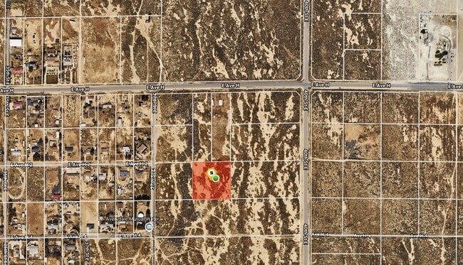
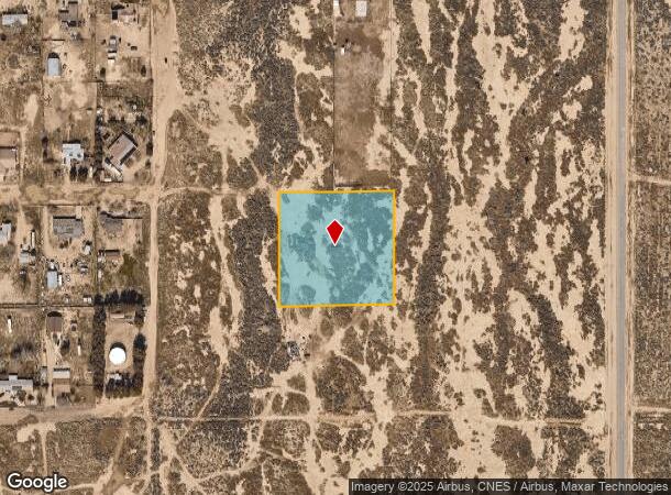
Avenue H2, Lancaster, CA 93535
This Property Is For Sale
NEARBY LISTINGS FOR SALE OR LEASE
Property Detail
Avenue H2
Los Angeles-Long Beach-Glendale, CA
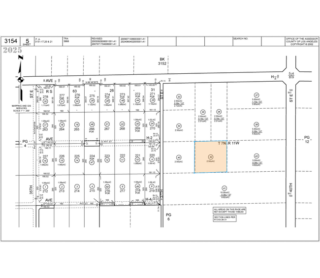
*NE 1/4 OF SW 1/4 OF NE 1/4 OF NE 1/4 SEC 8 T 7N R 11W
3154-005-042
Los Angeles
Desertorbarrenland
California
X
8
06037C0450F
2.58 AC
2024
Antelope Valley
2025
Los Angeles
900508
DEMOGRAPHICS near Avenue H2
1 Mile
3 Mile
5 Mile
2024 Total Population
3,173
32,809
83,466
2029 Population
3,079
31,982
81,053
Pop Growth 2024-2029
(2.96%)
(2.52%)
(2.89%)
Average Age
34
35
35
2024 Total Households
799
9,187
24,571
HH Growth 2024-2029
(3.38%)
(2.75%)
(3.13%)
Median Household Inc
$52,875
$46,708
$48,564
Avg Household Size
3.50
3.40
3.30
2024 Avg HH Vehicles
2.00
2.00
2.00
Median Home Value
$221,028
$141,371
$225,048
Median Year Built
1991
1985
1983
Nearby Places
- Restaurants
- Banks
- Shops
- Fitness
- Groceries
PUBLIC TRANSPORTATION
COMMUTER RAIL
Lancaster (Antelope Valley Line - Southern California Regional Rail Authority (Metrolink))
DRIVE
WALK
Distance
Lancaster (Antelope Valley Line - Southern California Regional Rail Authority (Metrolink))
10 min
5.9 mi
Freight Ports
Port of Long Beach
DRIVE
WALK
Distance
Port of Long Beach
120 min
101.5 mi
Nearby Properties
Address
Land Use
TOTAL SIZE
Lot Size
Zoning
Address
Land Use
TOTAL SIZE
Lot Size
Zoning
106,569 SF
38.45 AC
LRRR2.5
Address
Land Use
TOTAL SIZE
Lot Size
Zoning
876,730 SF
20.85 AC
LRCP
Address
Land Use
TOTAL SIZE
Lot Size
Zoning
481,066 SF
11.88 AC
LRRA7500*
Address
Land Use
TOTAL SIZE
Lot Size
Zoning
153,664 SF
9.23 AC
Address
Land Use
TOTAL SIZE
Lot Size
Zoning
113,960 SF
9 AC
LRD21*
Address
Land Use
TOTAL SIZE
Lot Size
Zoning
111,336 SF
8.54 AC
LRR17500*
Address
Land Use
TOTAL SIZE
Lot Size
Zoning
110,636 SF
6.86 AC
LRD2
Address
Land Use
TOTAL SIZE
Lot Size
Zoning
25,162 SF
4.26 AC
LRA22*
Address
Land Use
TOTAL SIZE
Lot Size
Zoning
144,800 SF
9.19 AC
LRRA7500*
Address
Land Use
TOTAL SIZE
Lot Size
Zoning
10.15 AC
LRMUC
Address
Land Use
TOTAL SIZE
Lot Size
Zoning
19,100 SF
1.83 AC
LRCPD
Address
Land Use
TOTAL SIZE
Lot Size
Zoning
27,268 SF
19.86 AC
LCA22*
Address
Land Use
TOTAL SIZE
Lot Size
Zoning
4,587 SF
0.69 AC
LRRA7500*
Address
Land Use
TOTAL SIZE
Lot Size
Zoning
3,062 SF
0.69 AC
LRCP
Address
Land Use
TOTAL SIZE
Lot Size
Zoning
7,731 SF
0.84 AC
LRCP
Address
Land Use
TOTAL SIZE
Lot Size
Zoning
6,380 SF
0.90 AC
LRCP
Address
Land Use
TOTAL SIZE
Lot Size
Zoning
4,799 SF
0.80 AC
LRCP
Address
Land Use
TOTAL SIZE
Lot Size
Zoning
11.34 AC
LRHDR
Address
Land Use
TOTAL SIZE
Lot Size
Zoning
42,572 SF
3.72 AC
R7000
Address
Land Use
TOTAL SIZE
Lot Size
Zoning
15,544 SF
1.94 AC
LRA22*
Address
Land Use
TOTAL SIZE
Lot Size
Zoning
2,466 SF
0.71 AC
LRCP
Address
Land Use
TOTAL SIZE
Lot Size
Zoning
950 SF
1.56 AC
LRCPD
Address
Land Use
TOTAL SIZE
Lot Size
Zoning
3,355 SF
0.70 AC
LRCP
Address
Land Use
TOTAL SIZE
Lot Size
Zoning
19.38 AC
LRRI7000
Address
Land Use
TOTAL SIZE
Lot Size
Zoning
2,632 SF
1.31 AC
LRCPD
Address
Land Use
TOTAL SIZE
Lot Size
Zoning
38.34 AC
LR7000
Address
Land Use
TOTAL SIZE
Lot Size
Zoning
2,660 SF
1 AC
LRCPD
Address
Land Use
TOTAL SIZE
Lot Size
Zoning
9,960 SF
9.01 AC
LRA22*
Address
Land Use
TOTAL SIZE
Lot Size
Zoning
11,970 SF
2.30 AC
LRLI
Address
Land Use
TOTAL SIZE
Lot Size
Zoning
279.67 AC
LCA21*
The World's #1 Commercial Real Estate Marketplace
Connect with us
© 2025 CoStar Group
The information above has been obtained from sources believed reliable. While we do not doubt its accuracy we have not verified it and make no guarantee, warranty or representation about it. It is your responsibility to independently confirm its accuracy and completeness. Any projections, opinions, assumptions, or estimates used are for example only and do not represent the current or future performance of the property. The value of this transaction to you depends on tax and other factors which should be evaluated by your tax, financial, and legal advisors. You and your advisors should conduct a careful, independent investigation of the property to determine to your satisfaction the suitability of the property for your needs.