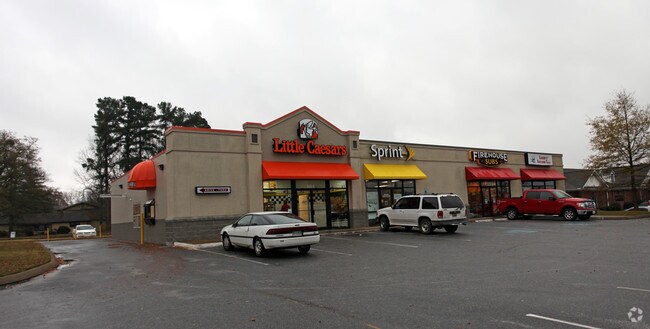
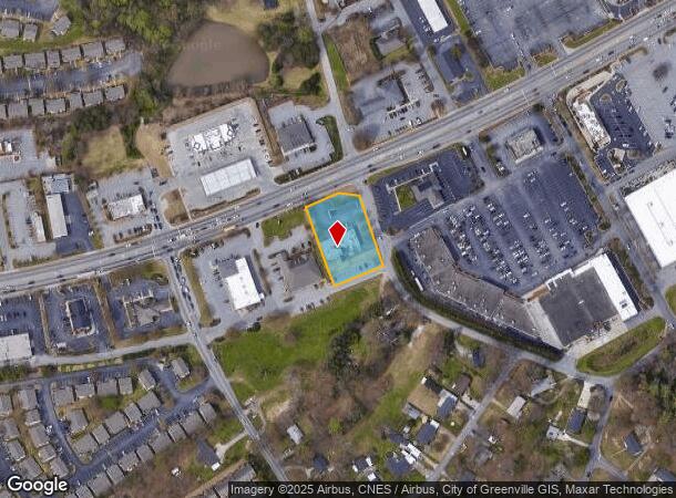
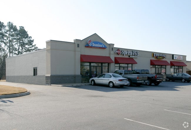
Property Record
W Butler Rd, Mauldin, SC 29662
NEARBY LISTINGS FOR SALE OR LEASE
Property Detail
W Butler Rd
Greenville-Anderson-Greer, SC
NONE,-
M006.02-01-001.01
Greenville
Stripcommercialcenter
South Carolina
X
001.01
45045C0414E
0.85 AC
2025
W Butler/Mauldin
2025
Greenville/Spartanburg
002903
DEMOGRAPHICS near W Butler Rd
1 mile
3 mile
5 mile
2024 Total Population
7,778
45,764
132,273
2029 Population
8,656
50,946
146,352
Pop Growth 2024-2029
+ 11.29%
+ 11.32%
+ 10.64%
Average Age
40
39
39
2024 Total Households
3,271
19,246
54,505
HH Growth 2024-2029
+ 11.37%
+ 11.47%
+ 10.78%
Median Household Inc
$69,830
$71,611
$76,277
Avg Household Size
2.40
2.30
2.40
2024 Avg HH Vehicles
2.00
2.00
2.00
Median Home Value
$219,679
$213,691
$248,701
Median Year Built
1995
1998
1995
Nearby Places
Map Layers
Map Styles
 Street
 Aerial
Transit
 Traffic
 Biking
Places
Listings with unknown addresses are not visible on the map
- Restaurants
- Banks
- Shops
- Fitness
- Groceries
PUBLIC TRANSPORTATION
COMMUTER RAIL
Drive
Walk
Distance
20 min
9.5 mi
AIRPORT
Greenville Spartanburg International
Drive
Walk
Distance
Greenville Spartanburg International
21 min
13.5 mi
Nearby Properties
Address
Land Use
TOTAL SIZE
Lot Size
Zoning
Address
Land Use
TOTAL SIZE
Lot Size
Zoning
23.23 AC
Address
Land Use
TOTAL SIZE
Lot Size
Zoning
15.82 AC
RM
Address
Land Use
TOTAL SIZE
Lot Size
Zoning
10.20 AC
R12
Address
Land Use
TOTAL SIZE
Lot Size
Zoning
10.29 AC
S1
Address
Land Use
TOTAL SIZE
Lot Size
Zoning
12.95 AC
RM3
Address
Land Use
TOTAL SIZE
Lot Size
Zoning
3.38 AC
S1
Address
Land Use
TOTAL SIZE
Lot Size
Zoning
9.10 AC
RM,C2
Address
Land Use
TOTAL SIZE
Lot Size
Zoning
20.30 AC
I1
Address
Land Use
TOTAL SIZE
Lot Size
Zoning
11.05 AC
S1
Address
Land Use
TOTAL SIZE
Lot Size
Zoning
12.31 AC
Address
Land Use
TOTAL SIZE
Lot Size
Zoning
17.59 AC
Address
Land Use
TOTAL SIZE
Lot Size
Zoning
6.27 AC
UVD
Address
Land Use
TOTAL SIZE
Lot Size
Zoning
10.36 AC
R12
Address
Land Use
TOTAL SIZE
Lot Size
Zoning
3.24 AC
S1
Address
Land Use
TOTAL SIZE
Lot Size
Zoning
15.14 AC
I1
Address
Land Use
TOTAL SIZE
Lot Size
Zoning
26.75 AC
S1
Address
Land Use
TOTAL SIZE
Lot Size
Zoning
11.91 AC
RM20
Address
Land Use
TOTAL SIZE
Lot Size
Zoning
Address
Land Use
TOTAL SIZE
Lot Size
Zoning
21.33 AC
Address
Land Use
TOTAL SIZE
Lot Size
Zoning
29.21 AC
I1
Address
Land Use
TOTAL SIZE
Lot Size
Zoning
108.12 AC
I1
Address
Land Use
TOTAL SIZE
Lot Size
Zoning
19.33 AC
S1
Address
Land Use
TOTAL SIZE
Lot Size
Zoning
40.92 AC
S1
Address
Land Use
TOTAL SIZE
Lot Size
Zoning
10.78 AC
I1
Address
Land Use
TOTAL SIZE
Lot Size
Zoning
24.12 AC
S1
Address
Land Use
TOTAL SIZE
Lot Size
Zoning
11.17 AC
C2
Address
Land Use
TOTAL SIZE
Lot Size
Zoning
5 AC
R12
Address
Land Use
TOTAL SIZE
Lot Size
Zoning
Address
Land Use
TOTAL SIZE
Lot Size
Zoning
25.70 AC
I1
Address
Land Use
TOTAL SIZE
Lot Size
Zoning
9.46 AC
I1
The World's #1 Commercial Real Estate Marketplace
Connect with us
© 2026 CoStar Group
The information above has been obtained from sources believed reliable. While we do not doubt its accuracy we have not verified it and make no guarantee, warranty or representation about it. It is your responsibility to independently confirm its accuracy and completeness. Any projections, opinions, assumptions, or estimates used are for example only and do not represent the current or future performance of the property. The value of this transaction to you depends on tax and other factors which should be evaluated by your tax, financial, and legal advisors. You and your advisors should conduct a careful, independent investigation of the property to determine to your satisfaction the suitability of the property for your needs.