Property Record
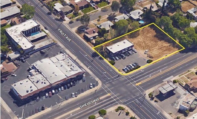
W Shields Ave, Fresno, CA 93705
NEARBY LISTINGS FOR SALE OR LEASE
Property Detail
W Shields Ave
Fresno, CA
1074 Kenth Manor
443-032-09
PARCEL IN LOT 2-4 & 12-15 TR NO 1074 KENTH MANOR
Commercialacreage
Fresno
X
California
06019C1565H
3
2025
0.54 AC
2025
Midtown
004703
Fresno
DEMOGRAPHICS near W Shields Ave
1 Mile
3 Mile
5 Mile
2024 Total Population
25,515
152,927
375,035
2029 Population
25,974
155,754
382,268
Pop Growth 2024-2029
+ 1.80%
+ 1.85%
+ 1.93%
Average Age
35
36
35
2024 Total Households
8,726
51,557
123,204
HH Growth 2024-2029
+ 1.78%
+ 1.86%
+ 1.95%
Median Household Inc
$53,031
$50,107
$52,448
Avg Household Size
2.90
2.80
2.90
2024 Avg HH Vehicles
2.00
2.00
2.00
Median Home Value
$266,917
$265,722
$280,838
Median Year Built
1957
1963
1971
Nearby Places
Map Layers
Map Styles
 Street
 Aerial
- Restaurants
- Banks
- Shops
- Fitness
- Groceries
PUBLIC TRANSPORTATION
COMMUTER RAIL
DRIVE
WALK
Distance
8 min
5.0 mi
AIRPORT
Fresno Yosemite International
DRIVE
WALK
Distance
Fresno Yosemite International
11 min
6.0 mi
SALE & LEASE HISTORY
LISTING DATE
SALE/LEASE

Sep 01, 2017
For Lease
Apr 04, 2019
For Sale
Nearby Properties
Address
Land Use
TOTAL SIZE
Lot Size
Zoning
Address
Land Use
TOTAL SIZE
Lot Size
Zoning
574,093 SF
25.54 AC
C3
Address
Land Use
TOTAL SIZE
Lot Size
Zoning
39,888 SF
23.72 AC
C3
Address
Land Use
TOTAL SIZE
Lot Size
Zoning
234,370 SF
23 AC
SPLIT
Address
Land Use
TOTAL SIZE
Lot Size
Zoning
232,183 SF
18.32 AC
R2A
Address
Land Use
TOTAL SIZE
Lot Size
Zoning
79,518 SF
2.03 AC
R4
Address
Land Use
TOTAL SIZE
Lot Size
Zoning
110,456 SF
6.56 AC
RMX
Address
Land Use
TOTAL SIZE
Lot Size
Zoning
126,346 SF
5.49 AC
CP
Address
Land Use
TOTAL SIZE
Lot Size
Zoning
126,346 SF
5.31 AC
CP
Address
Land Use
TOTAL SIZE
Lot Size
Zoning
669,447 SF
0.01 AC
C3
Address
Land Use
TOTAL SIZE
Lot Size
Zoning
70,168 SF
4.97 AC
R3
Address
Land Use
TOTAL SIZE
Lot Size
Zoning
179,240 SF
12 AC
C3
Address
Land Use
TOTAL SIZE
Lot Size
Zoning
203,687 SF
10.63 AC
R3
Address
Land Use
TOTAL SIZE
Lot Size
Zoning
121,250 SF
9.51 AC
R3
Address
Land Use
TOTAL SIZE
Lot Size
Zoning
159,822 SF
9.67 AC
R2
Address
Land Use
TOTAL SIZE
Lot Size
Zoning
81,754 SF
5.75 AC
C3
Address
Land Use
TOTAL SIZE
Lot Size
Zoning
110,341 SF
5.45 AC
R3
Address
Land Use
TOTAL SIZE
Lot Size
Zoning
88,859 SF
2.44 AC
CP
Address
Land Use
TOTAL SIZE
Lot Size
Zoning
191,136 SF
12.12 AC
R2
Address
Land Use
TOTAL SIZE
Lot Size
Zoning
92,096 SF
0.01 AC
C3
Address
Land Use
TOTAL SIZE
Lot Size
Zoning
145,783 SF
9.22 AC
R2
Address
Land Use
TOTAL SIZE
Lot Size
Zoning
108,017 SF
2.91 AC
CM
Address
Land Use
TOTAL SIZE
Lot Size
Zoning
82,484 SF
6.41 AC
CP
Address
Land Use
TOTAL SIZE
Lot Size
Zoning
45,944 SF
2.30 AC
CP
Address
Land Use
TOTAL SIZE
Lot Size
Zoning
372,640 SF
4.35 AC
CP
Address
Land Use
TOTAL SIZE
Lot Size
Zoning
57,408 SF
3.12 AC
R3
Address
Land Use
TOTAL SIZE
Lot Size
Zoning
77,520 SF
3.61 AC
C6
Address
Land Use
TOTAL SIZE
Lot Size
Zoning
127,394 SF
8.87 AC
R2
Address
Land Use
TOTAL SIZE
Lot Size
Zoning
81,413 SF
3.01 AC
CP
Address
Land Use
TOTAL SIZE
Lot Size
Zoning
71,384 SF
6.34 AC
IL
Address
Land Use
TOTAL SIZE
Lot Size
Zoning
83,622 SF
3.98 AC
M1
The World's #1 Commercial Real Estate Marketplace
Connect with us
© 2026 CoStar Group
The information above has been obtained from sources believed reliable. While we do not doubt its accuracy we have not verified it and make no guarantee, warranty or representation about it. It is your responsibility to independently confirm its accuracy and completeness. Any projections, opinions, assumptions, or estimates used are for example only and do not represent the current or future performance of the property. The value of this transaction to you depends on tax and other factors which should be evaluated by your tax, financial, and legal advisors. You and your advisors should conduct a careful, independent investigation of the property to determine to your satisfaction the suitability of the property for your needs.