Property Record
Walnut St, Selden, NY 11784

Save to a Folder
{{folder.Name}}
{{folder.ListingIds.length}} Properties
{{folder.ListingIds.length}} Property
Create a New Folder
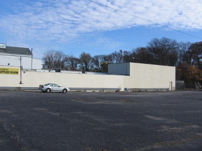
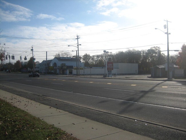
Property Detail
Walnut St
Nassau County-Suffolk County, NY
N MID CTRY RD 5 NCHLS LLC S11-53 S
0200-490-00-01-00-004-001
SUFFOLK
Vehiclerentalsvehiclesales
New York
B and X Area of moderate flood hazard, usually the area between the limits of the 100-year and 500-year floods.
100
2024
0.26 AC
2025
Central Suffolk
158112
Long Island (New York)
NEARBY LISTINGS FOR SALE OR LEASE
DEMOGRAPHICS near Walnut St
1 mile
3 mile
5 mile
2025 Total Population
12,580
97,631
236,027
2030 Population
12,361
96,696
234,805
Pop Growth 2025-2030
(1.74%)
(0.96%)
(0.52%)
Average Age
40
41
42
2025 Total Households
3,994
32,250
80,235
HH Growth 2025-2030
(2.08%)
(1.21%)
(0.77%)
Median Household Inc
$106,199
$117,621
$119,650
Avg Household Size
3.00
2.90
2.80
2025 Avg HH Vehicles
2.00
2.00
2.00
Median Home Value
$447,390
$482,480
$516,266
Median Year Built
1965
1972
1973
Nearby Places
Map Layers
Map Styles
 Street
 Aerial
Layers
 Traffic
 Biking
Places
Listings with unknown addresses are not visible on the map
- Restaurants
- Banks
- Shops
- Fitness
- Groceries
PUBLIC TRANSPORTATION
COMMUTER RAIL
Medford Station (Greenport Branch - Long Island Rail Road)
Drive
Walk
Distance
Medford Station (Greenport Branch - Long Island Rail Road)
11 min
6.4 mi
Port Jefferson Station (Port Jefferson Branch - Long Island Rail Road)
Drive
Walk
Distance
Port Jefferson Station (Port Jefferson Branch - Long Island Rail Road)
13 min
7.2 mi
AIRPORT
Long Island MacArthur
Drive
Walk
Distance
Long Island MacArthur
18 min
11.0 mi
Tweed/New Haven
Drive
Walk
Distance
Tweed/New Haven
130 min
47.6 mi
Freight Ports
Port of New Haven
Drive
Walk
Distance
Port of New Haven
124 min
45.5 mi
Nearby Properties
Address
Land Use
TOTAL SIZE
Lot Size
Zoning
Address
Land Use
TOTAL SIZE
Lot Size
Zoning
25.90 AC
Address
Land Use
TOTAL SIZE
Lot Size
Zoning
140.10 AC
Address
Land Use
TOTAL SIZE
Lot Size
Zoning
2,512 SF
1.45 AC
R20
Address
Land Use
TOTAL SIZE
Lot Size
Zoning
43.77 AC
Address
Land Use
TOTAL SIZE
Lot Size
Zoning
31.33 AC
Address
Land Use
TOTAL SIZE
Lot Size
Zoning
21.04 AC
Address
Land Use
TOTAL SIZE
Lot Size
Zoning
Address
Land Use
TOTAL SIZE
Lot Size
Zoning
47.20 AC
Address
Land Use
TOTAL SIZE
Lot Size
Zoning
34.53 AC
Address
Land Use
TOTAL SIZE
Lot Size
Zoning
38.42 AC
Address
Land Use
TOTAL SIZE
Lot Size
Zoning
27.75 AC
Address
Land Use
TOTAL SIZE
Lot Size
Zoning
41.67 AC
Address
Land Use
TOTAL SIZE
Lot Size
Zoning
49.83 AC
Address
Land Use
TOTAL SIZE
Lot Size
Zoning
22.52 AC
Address
Land Use
TOTAL SIZE
Lot Size
Zoning
Address
Land Use
TOTAL SIZE
Lot Size
Zoning
23.85 AC
Address
Land Use
TOTAL SIZE
Lot Size
Zoning
24.48 AC
Address
Land Use
TOTAL SIZE
Lot Size
Zoning
27.55 AC
Address
Land Use
TOTAL SIZE
Lot Size
Zoning
Address
Land Use
TOTAL SIZE
Lot Size
Zoning
16.50 AC
Address
Land Use
TOTAL SIZE
Lot Size
Zoning
Address
Land Use
TOTAL SIZE
Lot Size
Zoning
23.35 AC
Address
Land Use
TOTAL SIZE
Lot Size
Zoning
Address
Land Use
TOTAL SIZE
Lot Size
Zoning
14.11 AC
Address
Land Use
TOTAL SIZE
Lot Size
Zoning
23.91 AC
Address
Land Use
TOTAL SIZE
Lot Size
Zoning
25.30 AC
Address
Land Use
TOTAL SIZE
Lot Size
Zoning
17.63 AC
Address
Land Use
TOTAL SIZE
Lot Size
Zoning
23.72 AC
Address
Land Use
TOTAL SIZE
Lot Size
Zoning
12.40 AC
Address
Land Use
TOTAL SIZE
Lot Size
Zoning
The World's #1 Commercial Real Estate Marketplace
Connect with us
© 2026 CoStar Group
The information above has been obtained from sources believed reliable. While we do not doubt its accuracy we have not verified it and make no guarantee, warranty or representation about it. It is your responsibility to independently confirm its accuracy and completeness. Any projections, opinions, assumptions, or estimates used are for example only and do not represent the current or future performance of the property. The value of this transaction to you depends on tax and other factors which should be evaluated by your tax, financial, and legal advisors. You and your advisors should conduct a careful, independent investigation of the property to determine to your satisfaction the suitability of the property for your needs.