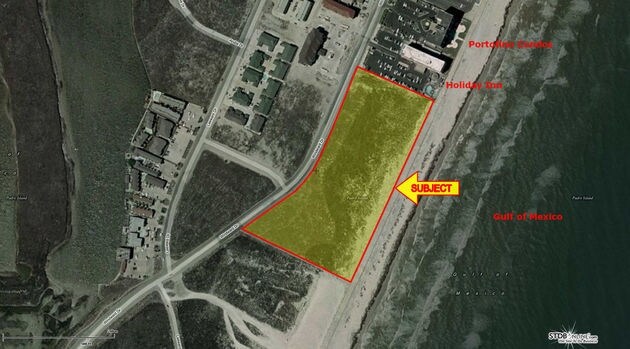
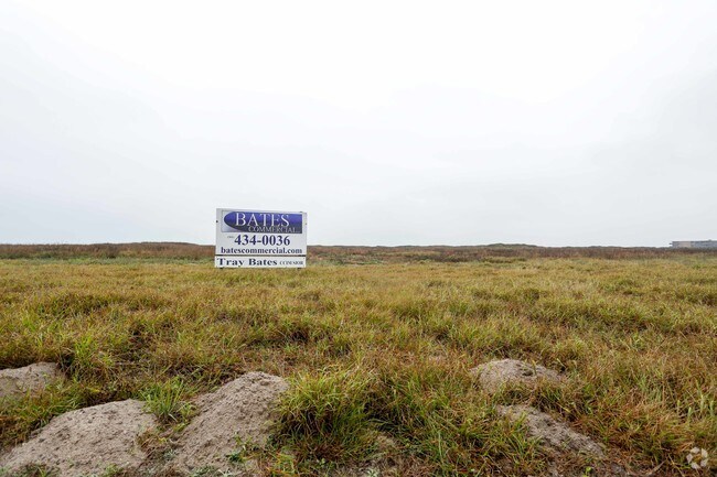
Property Record
Windward Dr, Corpus Christi, TX 78418
Property Detail
Windward Dr
Corpus Christi, TX
PADRE ISLAND SEC A TR A-2 BLK 45
279094
NUECES
Commercialacreage
Texas
B-2
a-2
VE and V1-30 Coastal areas with a 1% or greater chance of flooding and an additional hazard associated with storm waves. These areas have a 26% chance of flooding over the life of a 30-year mortgage.
5.53 AC
2024
Flour Bluff/Padre Island
2025
Corpus Christi
003101
NEARBY LISTINGS FOR SALE OR LEASE
DEMOGRAPHICS near Windward Dr
1 mile
3 mile
5 mile
2025 Total Population
1,665
12,931
12,931
2030 Population
1,866
13,588
13,588
Pop Growth 2025-2030
+ 12.07%
+ 5.08%
+ 5.08%
Average Age
49
45
45
2025 Total Households
800
5,578
5,578
HH Growth 2025-2030
+ 12.25%
+ 5.27%
+ 5.27%
Median Household Inc
$94,103
$130,514
$130,514
Avg Household Size
2.10
2.30
2.30
2025 Avg HH Vehicles
2.00
2.00
2.00
Median Home Value
$468,571
$444,379
$444,379
Median Year Built
1993
1999
1999
Nearby Places
Map Layers
Map Styles
 Street
 Aerial
Layers
 Traffic
 Biking
Places
Listings with unknown addresses are not visible on the map
- Restaurants
- Banks
- Shops
- Fitness
- Groceries
PUBLIC TRANSPORTATION
AIRPORT
Corpus Christi International
Drive
Walk
Distance
Corpus Christi International
36 min
24.7 mi
Freight Ports
Port of Corpus Christi
Drive
Walk
Distance
Port of Corpus Christi
30 min
20.5 mi
SALE & LEASE HISTORY
LISTING DATE
SALE/LEASE

Sep 24, 2016
For Sale
Nearby Properties
Address
Land Use
TOTAL SIZE
Lot Size
Zoning
Address
Land Use
TOTAL SIZE
Lot Size
Zoning
Address
Land Use
TOTAL SIZE
Lot Size
Zoning
138.88 AC
ATIO
Address
Land Use
TOTAL SIZE
Lot Size
Zoning
210 AC
F-R&AT
Address
Land Use
TOTAL SIZE
Lot Size
Zoning
176.01 AC
Address
Land Use
TOTAL SIZE
Lot Size
Zoning
80,205 SF
2.90 AC
B2IO
Address
Land Use
TOTAL SIZE
Lot Size
Zoning
19.57 AC
B2
Address
Land Use
TOTAL SIZE
Lot Size
Zoning
9,941 SF
195.92 AC
FRIO
Address
Land Use
TOTAL SIZE
Lot Size
Zoning
39.82 AC
ATIO
Address
Land Use
TOTAL SIZE
Lot Size
Zoning
51,256 SF
1.43 AC
AT
Address
Land Use
TOTAL SIZE
Lot Size
Zoning
11,170 SF
16.14 AC
R1B
Address
Land Use
TOTAL SIZE
Lot Size
Zoning
30,068 SF
3.10 AC
B2A
Address
Land Use
TOTAL SIZE
Lot Size
Zoning
Address
Land Use
TOTAL SIZE
Lot Size
Zoning
14,896 SF
1.93 AC
Address
Land Use
TOTAL SIZE
Lot Size
Zoning
35,914 SF
4.91 AC
B2A
Address
Land Use
TOTAL SIZE
Lot Size
Zoning
125,343 SF
28.63 AC
Address
Land Use
TOTAL SIZE
Lot Size
Zoning
5,520 SF
20 AC
FR
Address
Land Use
TOTAL SIZE
Lot Size
Zoning
4,350 SF
7.06 AC
B-2A
Address
Land Use
TOTAL SIZE
Lot Size
Zoning
26.84 AC
R1BIO
Address
Land Use
TOTAL SIZE
Lot Size
Zoning
24,790 SF
2.75 AC
B-2A
Address
Land Use
TOTAL SIZE
Lot Size
Zoning
18,500 SF
2 AC
B2AIO
Address
Land Use
TOTAL SIZE
Lot Size
Zoning
27,381 SF
3.20 AC
R2
Address
Land Use
TOTAL SIZE
Lot Size
Zoning
24,215 SF
2.15 AC
B-2A
Address
Land Use
TOTAL SIZE
Lot Size
Zoning
6.44 AC
B-2
Address
Land Use
TOTAL SIZE
Lot Size
Zoning
14,874 SF
0.36 AC
ATPUD2
Address
Land Use
TOTAL SIZE
Lot Size
Zoning
6.39 AC
B2IO
Address
Land Use
TOTAL SIZE
Lot Size
Zoning
14,874 SF
0.36 AC
ATPUD2
Address
Land Use
TOTAL SIZE
Lot Size
Zoning
6.63 AC
B2
Address
Land Use
TOTAL SIZE
Lot Size
Zoning
17,221 SF
1.88 AC
B2AIO
Address
Land Use
TOTAL SIZE
Lot Size
Zoning
4.12 AC
B2
Address
Land Use
TOTAL SIZE
Lot Size
Zoning
22,630 SF
1.62 AC
B-2A
The World's #1 Commercial Real Estate Marketplace
Connect with us
© 2026 CoStar Group
The information above has been obtained from sources believed reliable. While we do not doubt its accuracy we have not verified it and make no guarantee, warranty or representation about it. It is your responsibility to independently confirm its accuracy and completeness. Any projections, opinions, assumptions, or estimates used are for example only and do not represent the current or future performance of the property. The value of this transaction to you depends on tax and other factors which should be evaluated by your tax, financial, and legal advisors. You and your advisors should conduct a careful, independent investigation of the property to determine to your satisfaction the suitability of the property for your needs.