Property Record
1155 W State Road 434, Longwood, FL 32750


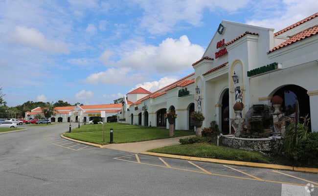
Property Detail
1155 W State Road 434
36-20-29-300-024C-0000
SEC 36 TWP 20S RGE 29E BEG 109 FT N & 483 FT W OF SE COR RUN W 751.15 FT TO E R/W HARBOUR ISLE WAY N 375 FT E 949.29 FT S 235.21 FT W 200.04 FT S TO BEG
Storebuilding
SEMINOLE
GC
Florida
AE The base floodplain where base flood elevations are provided. AE Zones are now used on new format FIRMs instead of A1-A30 Zones.
5.11 AC
2025
Longwood
2025
Orlando
021505
Orlando-Kissimmee-Sanford, FL
52,487 SF
NEARBY LISTINGS FOR SALE OR LEASE
DEMOGRAPHICS near 1155 W State Road 434
1 mile
3 mile
5 mile
2025 Total Population
8,001
79,339
211,444
2030 Population
8,550
84,274
224,110
Pop Growth 2025-2030
+ 6.86%
+ 6.22%
+ 5.99%
Average Age
45
43
42
2025 Total Households
2,879
33,556
86,888
HH Growth 2025-2030
+ 7.16%
+ 6.40%
+ 6.20%
Median Household Inc
$93,801
$72,238
$76,681
Avg Household Size
2.60
2.30
2.40
2025 Avg HH Vehicles
2.00
2.00
2.00
Median Home Value
$410,512
$373,945
$389,697
Median Year Built
1977
1982
1982
Nearby Places
Map Layers
Map Styles
 Street
 Aerial
Layers
 Traffic
 Biking
Places
Listings with unknown addresses are not visible on the map
- Restaurants
- Banks
- Shops
- Fitness
- Groceries
PUBLIC TRANSPORTATION
COMMUTER RAIL
Longwood (SunRail - Florida Department of Transportation)
Drive
Walk
Distance
Longwood (SunRail - Florida Department of Transportation)
4 min
2.1 mi
Altamonte Springs (SunRail - Florida Department of Transportation)
Drive
Walk
Distance
Altamonte Springs (SunRail - Florida Department of Transportation)
8 min
4.3 mi
AIRPORT
Orlando Sanford International
Drive
Walk
Distance
Orlando Sanford International
21 min
11.7 mi
Orlando International
Drive
Walk
Distance
Orlando International
37 min
21.1 mi
Freight Ports
Port Canaveral
Drive
Walk
Distance
Port Canaveral
82 min
63.1 mi
SALE & LEASE HISTORY
LISTING DATE
SALE/LEASE

Sep 25, 2016
For Lease
Nearby Properties
Address
Land Use
TOTAL SIZE
Lot Size
Zoning
Address
Land Use
TOTAL SIZE
Lot Size
Zoning
88,256 SF
39.64 AC
MOC3
Address
Land Use
TOTAL SIZE
Lot Size
Zoning
423,270 SF
3.45 AC
MOC3
Address
Land Use
TOTAL SIZE
Lot Size
Zoning
21.25 AC
GC
Address
Land Use
TOTAL SIZE
Lot Size
Zoning
130,246 SF
71.01 AC
PUD
Address
Land Use
TOTAL SIZE
Lot Size
Zoning
629,182 SF
1.81 AC
R1A
Address
Land Use
TOTAL SIZE
Lot Size
Zoning
1,158 SF
17.22 AC
Address
Land Use
TOTAL SIZE
Lot Size
Zoning
391,714 SF
42.59 AC
A1
Address
Land Use
TOTAL SIZE
Lot Size
Zoning
1,416 SF
23.80 AC
Address
Land Use
TOTAL SIZE
Lot Size
Zoning
Address
Land Use
TOTAL SIZE
Lot Size
Zoning
206 SF
1.43 AC
VMU
Address
Land Use
TOTAL SIZE
Lot Size
Zoning
400 SF
13.82 AC
R1AA
Address
Land Use
TOTAL SIZE
Lot Size
Zoning
5,256 SF
1.10 AC
PUDRES
Address
Land Use
TOTAL SIZE
Lot Size
Zoning
540 SF
7.72 AC
GC
Address
Land Use
TOTAL SIZE
Lot Size
Zoning
231,070 SF
35.59 AC
MOR2
Address
Land Use
TOTAL SIZE
Lot Size
Zoning
350,767 SF
11.12 AC
PUD
Address
Land Use
TOTAL SIZE
Lot Size
Zoning
560,170 SF
32.59 AC
M1A
Address
Land Use
TOTAL SIZE
Lot Size
Zoning
456 SF
9.56 AC
Address
Land Use
TOTAL SIZE
Lot Size
Zoning
1,428 SF
8.56 AC
MOR3
Address
Land Use
TOTAL SIZE
Lot Size
Zoning
97,888 SF
3.72 AC
IND
Address
Land Use
TOTAL SIZE
Lot Size
Zoning
3,140 SF
15.89 AC
PUD
Address
Land Use
TOTAL SIZE
Lot Size
Zoning
17,728 SF
14.64 AC
GC
Address
Land Use
TOTAL SIZE
Lot Size
Zoning
279,457 SF
20.56 AC
R3
Address
Land Use
TOTAL SIZE
Lot Size
Zoning
6,466 SF
18.97 AC
MOC3
Address
Land Use
TOTAL SIZE
Lot Size
Zoning
204 SF
30 AC
R3
Address
Land Use
TOTAL SIZE
Lot Size
Zoning
259,436 SF
11.23 AC
A1
Address
Land Use
TOTAL SIZE
Lot Size
Zoning
147,310 SF
14.74 AC
GC
Address
Land Use
TOTAL SIZE
Lot Size
Zoning
390,293 SF
47.33 AC
PI
Address
Land Use
TOTAL SIZE
Lot Size
Zoning
2,062 SF
7.30 AC
MOR2
Address
Land Use
TOTAL SIZE
Lot Size
Zoning
5,935 SF
2.27 AC
RMF13
Address
Land Use
TOTAL SIZE
Lot Size
Zoning
212,638 SF
28.72 AC
M1
The World's #1 Commercial Real Estate Marketplace
Connect with us
© 2026 CoStar Group
The information above has been obtained from sources believed reliable. While we do not doubt its accuracy we have not verified it and make no guarantee, warranty or representation about it. It is your responsibility to independently confirm its accuracy and completeness. Any projections, opinions, assumptions, or estimates used are for example only and do not represent the current or future performance of the property. The value of this transaction to you depends on tax and other factors which should be evaluated by your tax, financial, and legal advisors. You and your advisors should conduct a careful, independent investigation of the property to determine to your satisfaction the suitability of the property for your needs.