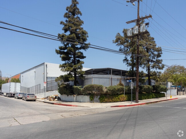
Property Record
10232 Norris Ave, Pacoima, CA 91331
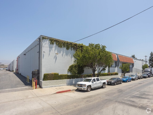


This Property Is For Sale
Current Lease Availabilities
Property Detail
10232 Norris Ave
2537-003-048
M R 37-5-16 1/2 VAC ST ADJ ON NE AND POR OF BLK 205
Warehouse
LOS ANGELES
LAM2
California
B and X Area of moderate flood hazard, usually the area between the limits of the 100-year and 500-year floods.
2.46 AC
2024
East San Ferndo Vlly
2025
Los Angeles
104620
Los Angeles-Long Beach-Glendale, CA
59,706 SF
NEARBY LISTINGS FOR SALE OR LEASE
DEMOGRAPHICS near 10232 Norris Ave
1 mile
3 mile
5 mile
2025 Total Population
13,860
167,037
526,371
2030 Population
13,509
163,706
521,806
Pop Growth 2025-2030
(2.53%)
(1.99%)
(0.87%)
Average Age
36
39
39
2025 Total Households
3,298
41,161
145,559
HH Growth 2025-2030
(2.82%)
(2.25%)
(1.03%)
Median Household Inc
$78,905
$83,069
$73,492
Avg Household Size
3.90
3.80
3.40
2025 Avg HH Vehicles
2.00
2.00
2.00
Median Home Value
$619,965
$717,091
$727,959
Median Year Built
1972
1959
1966
Nearby Places
Map Layers
Map Styles
 Street
 Aerial
Layers
 Traffic
 Biking
Places
Listings with unknown addresses are not visible on the map
- Restaurants
- Banks
- Shops
- Fitness
- Groceries
PUBLIC TRANSPORTATION
COMMUTER RAIL
Sun Valley (Antelope Valley Line - Southern California Regional Rail Authority (Metrolink))
Drive
Walk
Distance
Sun Valley (Antelope Valley Line - Southern California Regional Rail Authority (Metrolink))
6 min
3.7 mi
Sylmar/San Fernando (Antelope Valley Line - Southern California Regional Rail Authority (Metrolink))
Drive
Walk
Distance
Sylmar/San Fernando (Antelope Valley Line - Southern California Regional Rail Authority (Metrolink))
8 min
4.3 mi
AIRPORT
Bob Hope
Drive
Walk
Distance
Bob Hope
10 min
5.5 mi
Los Angeles International
Drive
Walk
Distance
Los Angeles International
40 min
27.7 mi
Freight Ports
Port of Long Beach
Drive
Walk
Distance
Port of Long Beach
57 min
43.0 mi
Nearby Properties
Address
Land Use
TOTAL SIZE
Lot Size
Zoning
Address
Land Use
TOTAL SIZE
Lot Size
Zoning
768,483 SF
6.87 AC
LAC1
Address
Land Use
TOTAL SIZE
Lot Size
Zoning
281,288 SF
34.03 AC
LAM2
Address
Land Use
TOTAL SIZE
Lot Size
Zoning
196,404 SF
10.06 AC
LARD1.5
Address
Land Use
TOTAL SIZE
Lot Size
Zoning
185,568 SF
9.06 AC
LARD1.5
Address
Land Use
TOTAL SIZE
Lot Size
Zoning
144,626 SF
5.15 AC
LAM2
Address
Land Use
TOTAL SIZE
Lot Size
Zoning
193,465 SF
4.67 AC
LAM3
Address
Land Use
TOTAL SIZE
Lot Size
Zoning
248,500 SF
11.01 AC
LAM2
Address
Land Use
TOTAL SIZE
Lot Size
Zoning
61,315 SF
0.84 AC
LARAS4
Address
Land Use
TOTAL SIZE
Lot Size
Zoning
257,802 SF
4.52 AC
LARA
Address
Land Use
TOTAL SIZE
Lot Size
Zoning
776,594 SF
16.18 AC
LAC2
Address
Land Use
TOTAL SIZE
Lot Size
Zoning
96,792 SF
5.52 AC
LARD2
Address
Land Use
TOTAL SIZE
Lot Size
Zoning
114,140 SF
4.94 AC
LAA1
Address
Land Use
TOTAL SIZE
Lot Size
Zoning
56,396 SF
0.74 AC
LARAS4
Address
Land Use
TOTAL SIZE
Lot Size
Zoning
75,050 SF
2.09 AC
LAC2
Address
Land Use
TOTAL SIZE
Lot Size
Zoning
165,573 SF
60.97 AC
LAM3
Address
Land Use
TOTAL SIZE
Lot Size
Zoning
146,718 SF
7.36 AC
Address
Land Use
TOTAL SIZE
Lot Size
Zoning
146,718 SF
7.11 AC
SFM
Address
Land Use
TOTAL SIZE
Lot Size
Zoning
74,764 SF
2.81 AC
LAR3
Address
Land Use
TOTAL SIZE
Lot Size
Zoning
11,067 SF
3.21 AC
LAM2
Address
Land Use
TOTAL SIZE
Lot Size
Zoning
154,575 SF
12.20 AC
LAM3
Address
Land Use
TOTAL SIZE
Lot Size
Zoning
120,590 SF
9.52 AC
SFM2-C1P*
Address
Land Use
TOTAL SIZE
Lot Size
Zoning
108,012 SF
6.40 AC
LAR3
Address
Land Use
TOTAL SIZE
Lot Size
Zoning
140,411 SF
10.79 AC
LAM3
Address
Land Use
TOTAL SIZE
Lot Size
Zoning
93,635 SF
4.97 AC
LAM2
Address
Land Use
TOTAL SIZE
Lot Size
Zoning
44,480 SF
2.72 AC
LAM2
Address
Land Use
TOTAL SIZE
Lot Size
Zoning
400,169 SF
11.47 AC
LAP
Address
Land Use
TOTAL SIZE
Lot Size
Zoning
250,064 SF
5.97 AC
LAM1
Address
Land Use
TOTAL SIZE
Lot Size
Zoning
170,161 SF
7.76 AC
LAMR2
Address
Land Use
TOTAL SIZE
Lot Size
Zoning
79,778 SF
3.90 AC
LARD1.5
The World's #1 Commercial Real Estate Marketplace
Connect with us
© 2026 CoStar Group
The information above has been obtained from sources believed reliable. While we do not doubt its accuracy we have not verified it and make no guarantee, warranty or representation about it. It is your responsibility to independently confirm its accuracy and completeness. Any projections, opinions, assumptions, or estimates used are for example only and do not represent the current or future performance of the property. The value of this transaction to you depends on tax and other factors which should be evaluated by your tax, financial, and legal advisors. You and your advisors should conduct a careful, independent investigation of the property to determine to your satisfaction the suitability of the property for your needs.