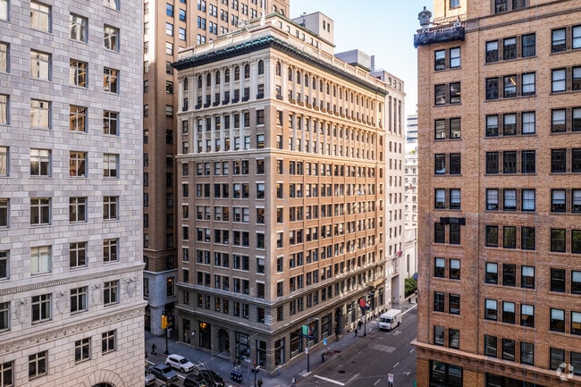
Property Record
115 Sansome St, San Francisco, CA 94104


Current Lease Availabilities
Property Detail
115 Sansome St
0268-002
SAN FRANCISCO
Officebuilding
California
C3O
2
2024
0.21 AC
2025
Financial District
011700
San Francisco
135,805 SF
San Francisco-San Mateo-Redwood City, CA
NEARBY LISTINGS FOR SALE OR LEASE
DEMOGRAPHICS near 115 Sansome St
1 mile
3 mile
5 mile
2025 Total Population
112,255
396,415
641,670
2030 Population
114,863
405,703
652,854
Pop Growth 2025-2030
+ 2.32%
+ 2.34%
+ 1.74%
Average Age
44
42
42
2025 Total Households
59,198
193,777
288,268
HH Growth 2025-2030
+ 2.18%
+ 2.24%
+ 1.79%
Median Household Inc
$87,686
$126,268
$133,106
Avg Household Size
1.70
1.90
2.10
2025 Avg HH Vehicles
.00
1.00
1.00
Median Home Value
$1,061,195
$1,090,608
$1,098,873
Median Year Built
1959
1954
1949
Nearby Places
Map Layers
Map Styles
 Street
 Aerial
Layers
 Traffic
 Biking
Places
Listings with unknown addresses are not visible on the map
- Restaurants
- Banks
- Shops
- Fitness
- Groceries
PUBLIC TRANSPORTATION
TRANSIT/SUBWAY
Market and 1st/Battery (F Market - San Francisco Municipal Railway (MUNI Metro))
Drive
Walk
Distance
Market and 1st/Battery (F Market - San Francisco Municipal Railway (MUNI Metro))
1 min
2 min
0.1 mi
Market and 2nd (F Market - San Francisco Municipal Railway (MUNI Metro))
Drive
Walk
Distance
Market and 2nd (F Market - San Francisco Municipal Railway (MUNI Metro))
1 min
2 min
0.1 mi
California and Sansome (California Street Cable Car - San Francisco Municipal Railway (MUNI Metro))
Drive
Walk
Distance
California and Sansome (California Street Cable Car - San Francisco Municipal Railway (MUNI Metro))
2 min
0.1 mi
Montgomery Station (Dublin/Pleasanton - Millbrae - Bay Area Rapid Transit (BART), Fremont - Daly City - Bay Area Rapid Transit (BART), Pittsburg/Bay Point - San Francisco International - Bay Area Rapid Transit (BART), Richmond - Millbrae - Bay Area Rapid Transit (BART))
Drive
Walk
Distance
Montgomery Station (Dublin/Pleasanton - Millbrae - Bay Area Rapid Transit (BART), Fremont - Daly City - Bay Area Rapid Transit (BART), Pittsburg/Bay Point - San Francisco International - Bay Area Rapid Transit (BART), Richmond - Millbrae - Bay Area Rapid Transit (BART))
1 min
3 min
0.2 mi
California and Battery (California Street Cable Car - San Francisco Municipal Railway (MUNI Metro))
Drive
Walk
Distance
California and Battery (California Street Cable Car - San Francisco Municipal Railway (MUNI Metro))
3 min
0.2 mi
COMMUTER RAIL
San Francisco 4th & King (Caltrain - Caltrain (Caltrain))
Drive
Walk
Distance
San Francisco 4th & King (Caltrain - Caltrain (Caltrain))
6 min
1.5 mi
22nd Street (Caltrain - Caltrain (Caltrain))
Drive
Walk
Distance
22nd Street (Caltrain - Caltrain (Caltrain))
12 min
3.4 mi
AIRPORT
San Francisco International
Drive
Walk
Distance
San Francisco International
18 min
13.8 mi
Metro Oakland International
Drive
Walk
Distance
Metro Oakland International
26 min
18.5 mi
Nearby Properties
Address
Land Use
TOTAL SIZE
Lot Size
Zoning
Address
Land Use
TOTAL SIZE
Lot Size
Zoning
1,015,000 SF
2.43 AC
RC4
Address
Land Use
TOTAL SIZE
Lot Size
Zoning
764,661 SF
0.67 AC
C3OSD
Address
Land Use
TOTAL SIZE
Lot Size
Zoning
750,370 SF
3.25 AC
MBR3
Address
Land Use
TOTAL SIZE
Lot Size
Zoning
1,471,929 SF
1.93 AC
C3O
Address
Land Use
TOTAL SIZE
Lot Size
Zoning
1,300,000 SF
1.74 AC
C3O
Address
Land Use
TOTAL SIZE
Lot Size
Zoning
1,420,430 SF
1.16 AC
C3OSD
Address
Land Use
TOTAL SIZE
Lot Size
Zoning
1,534,312 SF
2.60 AC
C3O
Address
Land Use
TOTAL SIZE
Lot Size
Zoning
914,037 SF
1.36 AC
C3O
Address
Land Use
TOTAL SIZE
Lot Size
Zoning
717,234 SF
3.47 AC
UMU
Address
Land Use
TOTAL SIZE
Lot Size
Zoning
605,459 SF
0.63 AC
C3O
Address
Land Use
TOTAL SIZE
Lot Size
Zoning
475,791 SF
0.55 AC
C3OSD
Address
Land Use
TOTAL SIZE
Lot Size
Zoning
690,442 SF
0.79 AC
C3O
Address
Land Use
TOTAL SIZE
Lot Size
Zoning
10.92 AC
Address
Land Use
TOTAL SIZE
Lot Size
Zoning
750,491 SF
0.51 AC
C3O
Address
Land Use
TOTAL SIZE
Lot Size
Zoning
432,000 SF
0.35 AC
C3OSD
Address
Land Use
TOTAL SIZE
Lot Size
Zoning
266,143 SF
4 AC
C-3-R
Address
Land Use
TOTAL SIZE
Lot Size
Zoning
885,581 SF
5.20 AC
M2
Address
Land Use
TOTAL SIZE
Lot Size
Zoning
512,395 SF
1.24 AC
C3O
Address
Land Use
TOTAL SIZE
Lot Size
Zoning
508,714 SF
1.29 AC
C3R
Address
Land Use
TOTAL SIZE
Lot Size
Zoning
1,084,662 SF
1.67 AC
C3O
Address
Land Use
TOTAL SIZE
Lot Size
Zoning
505,120 SF
0.41 AC
C3O
Address
Land Use
TOTAL SIZE
Lot Size
Zoning
694,334 SF
1.01 AC
C3O
Address
Land Use
TOTAL SIZE
Lot Size
Zoning
696,431 SF
0.97 AC
C3G
Address
Land Use
TOTAL SIZE
Lot Size
Zoning
139,070 SF
0.64 AC
C3O
Address
Land Use
TOTAL SIZE
Lot Size
Zoning
1.52 AC
C3G
Address
Land Use
TOTAL SIZE
Lot Size
Zoning
1,424,230 SF
2.60 AC
C3G
Address
Land Use
TOTAL SIZE
Lot Size
Zoning
614,740 SF
1.74 AC
C3OSD
Address
Land Use
TOTAL SIZE
Lot Size
Zoning
615,957 SF
0.63 AC
C3O
Address
Land Use
TOTAL SIZE
Lot Size
Zoning
492,980 SF
0.43 AC
C3O
Address
Land Use
TOTAL SIZE
Lot Size
Zoning
385,000 SF
0.81 AC
C3O
The World's #1 Commercial Real Estate Marketplace
Connect with us
© 2026 CoStar Group
The information above has been obtained from sources believed reliable. While we do not doubt its accuracy we have not verified it and make no guarantee, warranty or representation about it. It is your responsibility to independently confirm its accuracy and completeness. Any projections, opinions, assumptions, or estimates used are for example only and do not represent the current or future performance of the property. The value of this transaction to you depends on tax and other factors which should be evaluated by your tax, financial, and legal advisors. You and your advisors should conduct a careful, independent investigation of the property to determine to your satisfaction the suitability of the property for your needs.