Property Record
11822 Gilbert St, Garden Grove, CA 92841
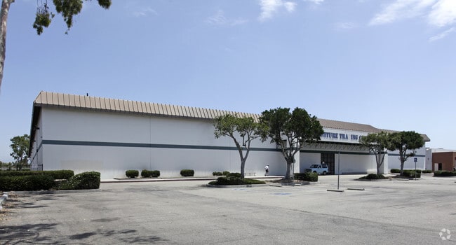


Property Detail
11822 Gilbert St
Anaheim-Santa Ana-Irvine, CA
P BK 216 PG 48 PAR 1
132-402-32
Orange
Commercialnec
California
C and X Area of minimal flood hazard, usually depicted on FIRMs as above the 500-year flood level.
1
2024
9.08 AC
2025
Garden Grove
088201
Orange County (California)
113,510 SF
NEARBY LISTINGS FOR SALE OR LEASE
DEMOGRAPHICS near 11822 Gilbert St
1 mile
3 mile
5 mile
2025 Total Population
27,424
289,005
755,724
2030 Population
27,430
289,143
755,267
Pop Growth 2025-2030
+ 0.02%
+ 0.05%
(0.06%)
Average Age
41
40
40
2025 Total Households
7,307
81,078
217,985
HH Growth 2025-2030
(0.10%)
(0.06%)
(0.17%)
Median Household Inc
$97,700
$82,098
$88,391
Avg Household Size
3.50
3.40
3.30
2025 Avg HH Vehicles
2.00
2.00
2.00
Median Home Value
$792,076
$729,704
$750,436
Median Year Built
1958
1966
1968
Nearby Places
Map Layers
Map Styles
 Street
 Aerial
Layers
 Traffic
 Biking
Places
Listings with unknown addresses are not visible on the map
- Restaurants
- Banks
- Shops
- Fitness
- Groceries
PUBLIC TRANSPORTATION
COMMUTER RAIL
Anaheim (Pacific Surfliner - Amtrak)
Drive
Walk
Distance
Anaheim (Pacific Surfliner - Amtrak)
13 min
6.5 mi
Anaheim-Artic Metrolink Station (Metrolink Orange County Line - Metrolink Trains)
Drive
Walk
Distance
Anaheim-Artic Metrolink Station (Metrolink Orange County Line - Metrolink Trains)
13 min
6.6 mi
AIRPORT
John Wayne/Orange County
Drive
Walk
Distance
John Wayne/Orange County
21 min
12.2 mi
Long Beach (Daugherty Field)
Drive
Walk
Distance
Long Beach (Daugherty Field)
21 min
15.1 mi
Los Angeles International
Drive
Walk
Distance
Los Angeles International
45 min
33.9 mi
Freight Ports
Port of Long Beach
Drive
Walk
Distance
Port of Long Beach
26 min
14.6 mi
Nearby Properties
Address
Land Use
TOTAL SIZE
Lot Size
Zoning
Address
Land Use
TOTAL SIZE
Lot Size
Zoning
24.50 AC
Address
Land Use
TOTAL SIZE
Lot Size
Zoning
16.07 AC
Address
Land Use
TOTAL SIZE
Lot Size
Zoning
Address
Land Use
TOTAL SIZE
Lot Size
Zoning
615,528 SF
17.93 AC
Address
Land Use
TOTAL SIZE
Lot Size
Zoning
2.86 AC
Address
Land Use
TOTAL SIZE
Lot Size
Zoning
6.45 AC
Address
Land Use
TOTAL SIZE
Lot Size
Zoning
860 SF
13 AC
Address
Land Use
TOTAL SIZE
Lot Size
Zoning
Address
Land Use
TOTAL SIZE
Lot Size
Zoning
Address
Land Use
TOTAL SIZE
Lot Size
Zoning
2.17 AC
Address
Land Use
TOTAL SIZE
Lot Size
Zoning
46,514 SF
9.18 AC
Address
Land Use
TOTAL SIZE
Lot Size
Zoning
8.80 AC
Address
Land Use
TOTAL SIZE
Lot Size
Zoning
7,939 SF
9.37 AC
Address
Land Use
TOTAL SIZE
Lot Size
Zoning
9.28 AC
Address
Land Use
TOTAL SIZE
Lot Size
Zoning
10.90 AC
Address
Land Use
TOTAL SIZE
Lot Size
Zoning
3.43 AC
Address
Land Use
TOTAL SIZE
Lot Size
Zoning
0.37 AC
Address
Land Use
TOTAL SIZE
Lot Size
Zoning
316,420 SF
11.72 AC
Address
Land Use
TOTAL SIZE
Lot Size
Zoning
4.86 AC
Address
Land Use
TOTAL SIZE
Lot Size
Zoning
Address
Land Use
TOTAL SIZE
Lot Size
Zoning
164,419 SF
5.22 AC
Address
Land Use
TOTAL SIZE
Lot Size
Zoning
25.40 AC
Address
Land Use
TOTAL SIZE
Lot Size
Zoning
Address
Land Use
TOTAL SIZE
Lot Size
Zoning
7.71 AC
Address
Land Use
TOTAL SIZE
Lot Size
Zoning
Address
Land Use
TOTAL SIZE
Lot Size
Zoning
Address
Land Use
TOTAL SIZE
Lot Size
Zoning
Address
Land Use
TOTAL SIZE
Lot Size
Zoning
Address
Land Use
TOTAL SIZE
Lot Size
Zoning
199,534 SF
12.89 AC
Address
Land Use
TOTAL SIZE
Lot Size
Zoning
3.12 AC
The World's #1 Commercial Real Estate Marketplace
Connect with us
© 2026 CoStar Group
The information above has been obtained from sources believed reliable. While we do not doubt its accuracy we have not verified it and make no guarantee, warranty or representation about it. It is your responsibility to independently confirm its accuracy and completeness. Any projections, opinions, assumptions, or estimates used are for example only and do not represent the current or future performance of the property. The value of this transaction to you depends on tax and other factors which should be evaluated by your tax, financial, and legal advisors. You and your advisors should conduct a careful, independent investigation of the property to determine to your satisfaction the suitability of the property for your needs.