Property Record
1312 Winborne St Sw, Roanoke, VA 24015

Save to a Folder
{{folder.Name}}
{{folder.ListingIds.length}} Properties
{{folder.ListingIds.length}} Property
Create a New Folder
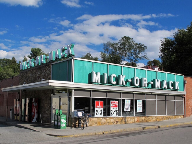
Property Detail
1312 Winborne St Sw
133-0607
TRACT A BLK 3 NEWLAND MAP GHENT
Multipleuses
Roanoke City
CN
Virginia
B and X Area of moderate flood hazard, usually the area between the limits of the 100-year and 500-year floods.
4-7
2026
0.93 AC
2026
Southwest Roanoke
001800
Roanoke
10,836 SF
Roanoke, VA
NEARBY LISTINGS FOR SALE OR LEASE
DEMOGRAPHICS near 1312 Winborne St Sw
1 mile
3 mile
5 mile
2025 Total Population
11,030
74,132
157,357
2030 Population
10,939
73,774
157,417
Pop Growth 2025-2030
(0.83%)
(0.48%)
+ 0.04%
Average Age
40
40
41
2025 Total Households
5,165
33,502
68,950
HH Growth 2025-2030
(1.05%)
(0.50%)
+ 0.02%
Median Household Inc
$62,011
$55,986
$60,281
Avg Household Size
2.10
2.10
2.20
2025 Avg HH Vehicles
2.00
2.00
2.00
Median Home Value
$278,637
$253,729
$251,541
Median Year Built
1947
1958
1966
Nearby Places
Map Layers
Map Styles
 Street
 Aerial
Layers
 Traffic
 Biking
Places
Listings with unknown addresses are not visible on the map
- Restaurants
- Banks
- Shops
- Fitness
- Groceries
PUBLIC TRANSPORTATION
COMMUTER RAIL
Drive
Walk
Distance
6 min
2.1 mi
AIRPORT
Roanoke/Blacksburg Regional (Woodrum Field)
Drive
Walk
Distance
Roanoke/Blacksburg Regional (Woodrum Field)
17 min
7.5 mi
Nearby Properties
Address
Land Use
TOTAL SIZE
Lot Size
Zoning
Address
Land Use
TOTAL SIZE
Lot Size
Zoning
998,139 SF
20.12 AC
INPUD
Address
Land Use
TOTAL SIZE
Lot Size
Zoning
160 AC
RSF
Address
Land Use
TOTAL SIZE
Lot Size
Zoning
41,443 SF
96.33 AC
INPUD
Address
Land Use
TOTAL SIZE
Lot Size
Zoning
476,613 SF
5.29 AC
D
Address
Land Use
TOTAL SIZE
Lot Size
Zoning
437,578 SF
14.74 AC
CLS
Address
Land Use
TOTAL SIZE
Lot Size
Zoning
96,620 SF
26.84 AC
D
Address
Land Use
TOTAL SIZE
Lot Size
Zoning
217,815 SF
3.02 AC
INPUD
Address
Land Use
TOTAL SIZE
Lot Size
Zoning
87,406 SF
1.15 AC
D
Address
Land Use
TOTAL SIZE
Lot Size
Zoning
211,622 SF
2.18 AC
INPUD
Address
Land Use
TOTAL SIZE
Lot Size
Zoning
47,181 SF
33.94 AC
INPUD
Address
Land Use
TOTAL SIZE
Lot Size
Zoning
19,734 SF
34.83 AC
INPUD
Address
Land Use
TOTAL SIZE
Lot Size
Zoning
1.51 AC
INPUD
Address
Land Use
TOTAL SIZE
Lot Size
Zoning
177,095 SF
18.55 AC
RMF
Address
Land Use
TOTAL SIZE
Lot Size
Zoning
262,715 SF
5.09 AC
D
Address
Land Use
TOTAL SIZE
Lot Size
Zoning
100,606 SF
2.10 AC
INPUD
Address
Land Use
TOTAL SIZE
Lot Size
Zoning
138,261 SF
22.24 AC
CLS
Address
Land Use
TOTAL SIZE
Lot Size
Zoning
1.25 AC
D
Address
Land Use
TOTAL SIZE
Lot Size
Zoning
504,343 SF
2.80 AC
INPUD
Address
Land Use
TOTAL SIZE
Lot Size
Zoning
59,641 SF
5.63 AC
INPUD
Address
Land Use
TOTAL SIZE
Lot Size
Zoning
81,500 SF
0.63 AC
D
Address
Land Use
TOTAL SIZE
Lot Size
Zoning
12,220 SF
5.09 AC
D
Address
Land Use
TOTAL SIZE
Lot Size
Zoning
150,151 SF
0.84 AC
D
Address
Land Use
TOTAL SIZE
Lot Size
Zoning
65,502 SF
2.89 AC
INPUD
Address
Land Use
TOTAL SIZE
Lot Size
Zoning
33,249 SF
5.50 AC
D
Address
Land Use
TOTAL SIZE
Lot Size
Zoning
141,056 SF
2.49 AC
D
Address
Land Use
TOTAL SIZE
Lot Size
Zoning
7,279 SF
24.35 AC
R3C
Address
Land Use
TOTAL SIZE
Lot Size
Zoning
206,418 SF
1.50 AC
D
Address
Land Use
TOTAL SIZE
Lot Size
Zoning
67,486 SF
3.99 AC
RMF
Address
Land Use
TOTAL SIZE
Lot Size
Zoning
73,575 SF
2.52 AC
D
Address
Land Use
TOTAL SIZE
Lot Size
Zoning
122,814 SF
0.98 AC
INPUD
The World's #1 Commercial Real Estate Marketplace
Connect with us
© 2026 CoStar Group
The information above has been obtained from sources believed reliable. While we do not doubt its accuracy we have not verified it and make no guarantee, warranty or representation about it. It is your responsibility to independently confirm its accuracy and completeness. Any projections, opinions, assumptions, or estimates used are for example only and do not represent the current or future performance of the property. The value of this transaction to you depends on tax and other factors which should be evaluated by your tax, financial, and legal advisors. You and your advisors should conduct a careful, independent investigation of the property to determine to your satisfaction the suitability of the property for your needs.