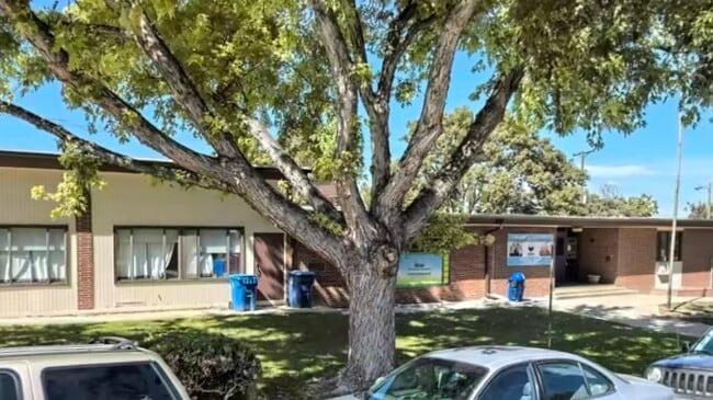
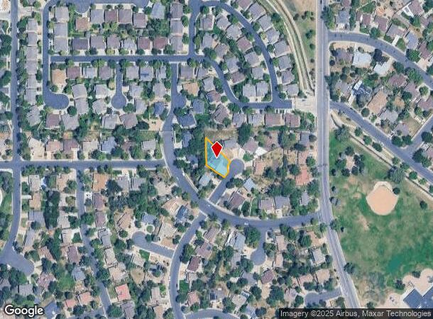
Property Record
1353 S Macon St, Aurora, CO 80012


NEARBY LISTINGS FOR SALE OR LEASE
Property Detail
1353 S Macon St
Denver-Aurora-Lakewood, CO
Village East Unit 3 6Th Flg
1973-23-1-10-004
Arapahoe
Sfr
Colorado
X
0.22 AC
08005C0178K
Aurora
2,046 SF
Denver
DEMOGRAPHICS near 1353 S Macon St
1 Mile
3 Mile
5 Mile
2024 Total Population
25,361
170,877
420,468
2029 Population
25,579
173,880
425,539
Pop Growth 2024-2029
+ 0.86%
+ 1.76%
+ 1.21%
Average Age
35
37
37
2024 Total Households
8,441
63,790
164,738
HH Growth 2024-2029
+ 0.88%
+ 1.74%
+ 1.22%
Median Household Inc
$50,705
$62,410
$70,614
Avg Household Size
2.80
2.50
2.40
2024 Avg HH Vehicles
2.00
2.00
2.00
Median Home Value
$356,480
$414,331
$444,186
Median Year Built
1959
1978
1980
Nearby Places
Map Layers
Map Styles
 Street
 Aerial
- Restaurants
- Banks
- Shops
- Fitness
- Groceries
PUBLIC TRANSPORTATION
COMMUTER RAIL
Peoria Station Track 1 (Union Station to Denver Airport Station - Regional Transportation District)
DRIVE
WALK
Distance
Peoria Station Track 1 (Union Station to Denver Airport Station - Regional Transportation District)
14 min
8.7 mi
Peoria Station Track 2 (Union Station to Denver Airport Station - Regional Transportation District)
DRIVE
WALK
Distance
Peoria Station Track 2 (Union Station to Denver Airport Station - Regional Transportation District)
14 min
8.7 mi
AIRPORT
Denver International
DRIVE
WALK
Distance
Denver International
27 min
20.4 mi
Freight Ports
Tulsa Port Of Catoosa
DRIVE
WALK
Distance
Tulsa Port Of Catoosa
724 min
703.1 mi
SALE & LEASE HISTORY
LISTING DATE
SALE/LEASE

Jan 03, 2025
For Lease
Nearby Properties
Address
Land Use
TOTAL SIZE
Lot Size
Zoning
Address
Land Use
TOTAL SIZE
Lot Size
Zoning
496,493 SF
33.45 AC
Address
Land Use
TOTAL SIZE
Lot Size
Zoning
476,186 SF
42.62 AC
Address
Land Use
TOTAL SIZE
Lot Size
Zoning
315,058 SF
36.85 AC
RPCZD
Address
Land Use
TOTAL SIZE
Lot Size
Zoning
613,600 SF
29.40 AC
R-3
Address
Land Use
TOTAL SIZE
Lot Size
Zoning
384,886 SF
18.66 AC
R-2-A
Address
Land Use
TOTAL SIZE
Lot Size
Zoning
277,985 SF
19.07 AC
Address
Land Use
TOTAL SIZE
Lot Size
Zoning
201,600 SF
44.67 AC
R1
Address
Land Use
TOTAL SIZE
Lot Size
Zoning
368,676 SF
17.71 AC
R-2-A
Address
Land Use
TOTAL SIZE
Lot Size
Zoning
478,994 SF
26.07 AC
Address
Land Use
TOTAL SIZE
Lot Size
Zoning
130,531 SF
3.41 AC
Address
Land Use
TOTAL SIZE
Lot Size
Zoning
540,380 SF
26.03 AC
RR3
Address
Land Use
TOTAL SIZE
Lot Size
Zoning
205,250 SF
10 AC
I-A
Address
Land Use
TOTAL SIZE
Lot Size
Zoning
220,395 SF
7.93 AC
Address
Land Use
TOTAL SIZE
Lot Size
Zoning
154,808 SF
16.71 AC
S-SU-D
Address
Land Use
TOTAL SIZE
Lot Size
Zoning
138,750 SF
12.17 AC
OS-A
Address
Land Use
TOTAL SIZE
Lot Size
Zoning
244,350 SF
9.59 AC
S-MU-5
Address
Land Use
TOTAL SIZE
Lot Size
Zoning
462,048 SF
5.34 AC
RB3
Address
Land Use
TOTAL SIZE
Lot Size
Zoning
333,696 SF
17.52 AC
PUD
Address
Land Use
TOTAL SIZE
Lot Size
Zoning
521,364 SF
14.88 AC
PUD
Address
Land Use
TOTAL SIZE
Lot Size
Zoning
506,272 SF
20.38 AC
PUD
Address
Land Use
TOTAL SIZE
Lot Size
Zoning
1,344,255 SF
15.88 AC
AMU
Address
Land Use
TOTAL SIZE
Lot Size
Zoning
209,690 SF
7.21 AC
S-SU-D
Address
Land Use
TOTAL SIZE
Lot Size
Zoning
145,915 SF
11.01 AC
B-3
Address
Land Use
TOTAL SIZE
Lot Size
Zoning
350,692 SF
13.51 AC
R-2-A
Address
Land Use
TOTAL SIZE
Lot Size
Zoning
649,712 SF
47.31 AC
Address
Land Use
TOTAL SIZE
Lot Size
Zoning
232,697 SF
12.09 AC
Address
Land Use
TOTAL SIZE
Lot Size
Zoning
328,315 SF
8.15 AC
Address
Land Use
TOTAL SIZE
Lot Size
Zoning
238,669 SF
5.58 AC
B-2
Address
Land Use
TOTAL SIZE
Lot Size
Zoning
143,394 SF
8.15 AC
B-3
Address
Land Use
TOTAL SIZE
Lot Size
Zoning
353,956 SF
8.28 AC
R-3
The World's #1 Commercial Real Estate Marketplace
Connect with us
© 2025 CoStar Group
The information above has been obtained from sources believed reliable. While we do not doubt its accuracy we have not verified it and make no guarantee, warranty or representation about it. It is your responsibility to independently confirm its accuracy and completeness. Any projections, opinions, assumptions, or estimates used are for example only and do not represent the current or future performance of the property. The value of this transaction to you depends on tax and other factors which should be evaluated by your tax, financial, and legal advisors. You and your advisors should conduct a careful, independent investigation of the property to determine to your satisfaction the suitability of the property for your needs.