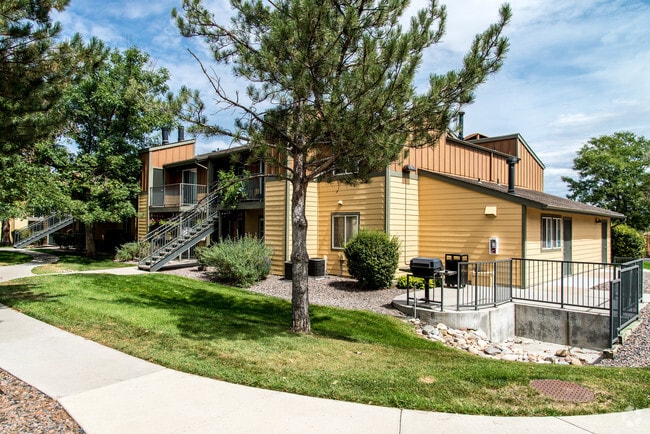
Property Record
13711 E Richthofen Cir, Aurora, CO 80011


NEARBY LISTINGS FOR SALE OR LEASE
Property Detail
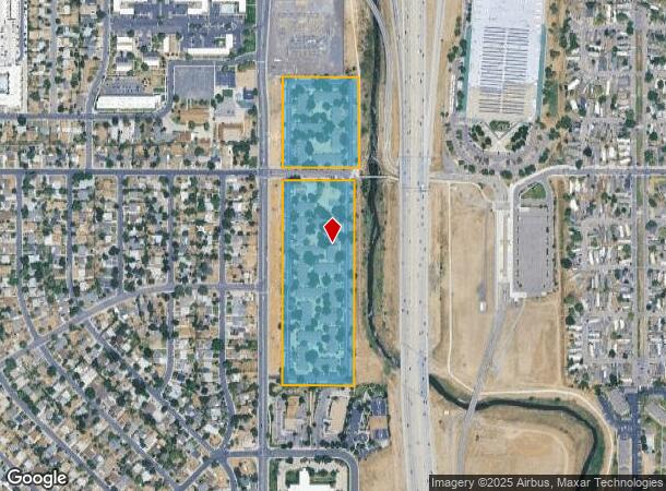
13711 E Richthofen Cir
Denver-Aurora-Centennial, CO
Timberwood Sub 1St Flg
1975-06-2-08-002
SUBDIVISIONCD 062067 SUBDIVISIONNAME TIMBERWOOD SUB 1ST FLG BLOCK 001 LOT 001 LOT 1 BLK 1 & LOT 1 BLK 2 TIMBERWOOD SUB 1ST FLG
Apartment
Arapahoe
AE
Colorado
08005C0177L
001,1
2024
15.14 AC
2025
Jewell Heights-Hoffman Heights
007600
Denver
265,008 SF
DEMOGRAPHICS near 13711 E Richthofen Cir
1 Mile
3 Mile
5 Mile
2024 Total Population
21,131
152,117
385,512
2029 Population
21,419
154,728
390,688
Pop Growth 2024-2029
+ 1.36%
+ 1.72%
+ 1.34%
Average Age
35
35
37
2024 Total Households
7,180
53,275
143,627
HH Growth 2024-2029
+ 1.59%
+ 1.82%
+ 1.38%
Median Household Inc
$50,055
$56,713
$68,212
Avg Household Size
2.80
2.70
2.60
2024 Avg HH Vehicles
2.00
2.00
2.00
Median Home Value
$328,038
$352,188
$389,145
Median Year Built
1978
1979
1983
Nearby Places
Map Layers
Map Styles
 Street
 Aerial
- Restaurants
- Banks
- Shops
- Fitness
- Groceries
PUBLIC TRANSPORTATION
TRANSIT/SUBWAY
13Th Ave Station (Lincoln Station to Peoria Station - Regional Transportation District)
DRIVE
WALK
Distance
13Th Ave Station (Lincoln Station to Peoria Station - Regional Transportation District)
4 min
8 min
0.4 mi
Colfax Station (Lincoln Station to Peoria Station - Regional Transportation District)
DRIVE
WALK
Distance
Colfax Station (Lincoln Station to Peoria Station - Regional Transportation District)
1 min
8 min
0.4 mi
COMMUTER RAIL
Peoria Station Track 1 (Union Station to Denver Airport Station - Regional Transportation District)
DRIVE
WALK
Distance
Peoria Station Track 1 (Union Station to Denver Airport Station - Regional Transportation District)
7 min
3.7 mi
Peoria Station Track 2 (Union Station to Denver Airport Station - Regional Transportation District)
DRIVE
WALK
Distance
Peoria Station Track 2 (Union Station to Denver Airport Station - Regional Transportation District)
7 min
3.7 mi
AIRPORT
Denver International
DRIVE
WALK
Distance
Denver International
21 min
16.1 mi
Freight Ports
Tulsa Port Of Catoosa
DRIVE
WALK
Distance
Tulsa Port Of Catoosa
716 min
698.8 mi
Nearby Properties
Address
Land Use
TOTAL SIZE
Lot Size
Zoning
Address
Land Use
TOTAL SIZE
Lot Size
Zoning
368,450 SF
48.59 AC
Address
Land Use
TOTAL SIZE
Lot Size
Zoning
353,829 SF
4.51 AC
Address
Land Use
TOTAL SIZE
Lot Size
Zoning
880,442 SF
67.95 AC
I-B
Address
Land Use
TOTAL SIZE
Lot Size
Zoning
525,050 SF
105.06 AC
Address
Land Use
TOTAL SIZE
Lot Size
Zoning
116,490 SF
3.71 AC
PUD
Address
Land Use
TOTAL SIZE
Lot Size
Zoning
140,419 SF
8.37 AC
Address
Land Use
TOTAL SIZE
Lot Size
Zoning
161,437 SF
2.22 AC
RCZDC
Address
Land Use
TOTAL SIZE
Lot Size
Zoning
97,001 SF
Address
Land Use
TOTAL SIZE
Lot Size
Zoning
876,549 SF
46.65 AC
Address
Land Use
TOTAL SIZE
Lot Size
Zoning
868,780 SF
105.02 AC
Address
Land Use
TOTAL SIZE
Lot Size
Zoning
87,346 SF
1.76 AC
RFBAD
Address
Land Use
TOTAL SIZE
Lot Size
Zoning
691,200 SF
38.09 AC
Address
Land Use
TOTAL SIZE
Lot Size
Zoning
273,184 SF
1.89 AC
Address
Land Use
TOTAL SIZE
Lot Size
Zoning
201,600 SF
44.67 AC
R1
Address
Land Use
TOTAL SIZE
Lot Size
Zoning
313,993 SF
5.69 AC
Address
Land Use
TOTAL SIZE
Lot Size
Zoning
57,392 SF
0.72 AC
Address
Land Use
TOTAL SIZE
Lot Size
Zoning
140.42 AC
Address
Land Use
TOTAL SIZE
Lot Size
Zoning
557,843 SF
21.35 AC
PUD
Address
Land Use
TOTAL SIZE
Lot Size
Zoning
83,951 SF
0.30 AC
R2
Address
Land Use
TOTAL SIZE
Lot Size
Zoning
315,058 SF
36.85 AC
RPCZD
Address
Land Use
TOTAL SIZE
Lot Size
Zoning
47,616 SF
140.42 AC
PUD
Address
Land Use
TOTAL SIZE
Lot Size
Zoning
43,568 SF
1.53 AC
Address
Land Use
TOTAL SIZE
Lot Size
Zoning
269,622 SF
12.90 AC
Address
Land Use
TOTAL SIZE
Lot Size
Zoning
277,985 SF
19.07 AC
Address
Land Use
TOTAL SIZE
Lot Size
Zoning
178,235 SF
1.38 AC
RFBAD
Address
Land Use
TOTAL SIZE
Lot Size
Zoning
51,075 SF
0.72 AC
Address
Land Use
TOTAL SIZE
Lot Size
Zoning
238,845 SF
1.70 AC
Address
Land Use
TOTAL SIZE
Lot Size
Zoning
624,019 SF
4.09 AC
Address
Land Use
TOTAL SIZE
Lot Size
Zoning
672,521 SF
0.61 AC
RB3
Address
Land Use
TOTAL SIZE
Lot Size
Zoning
400,000 SF
22.91 AC
I-0
The World's #1 Commercial Real Estate Marketplace
Connect with us
© 2026 CoStar Group
The information above has been obtained from sources believed reliable. While we do not doubt its accuracy we have not verified it and make no guarantee, warranty or representation about it. It is your responsibility to independently confirm its accuracy and completeness. Any projections, opinions, assumptions, or estimates used are for example only and do not represent the current or future performance of the property. The value of this transaction to you depends on tax and other factors which should be evaluated by your tax, financial, and legal advisors. You and your advisors should conduct a careful, independent investigation of the property to determine to your satisfaction the suitability of the property for your needs.