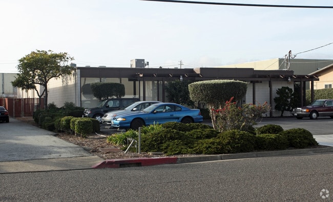
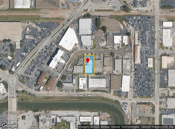
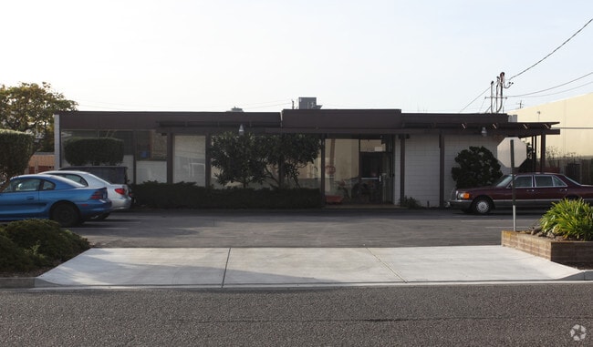
Property Record
138 W Harris Ave, South San Francisco, CA 94080
Current Lease Availabilities
NEARBY LISTINGS FOR SALE OR LEASE
Property Detail
138 W Harris Ave
San Francisco-Redwood City-South San Francisco, CA
So San Francisco Ind Park
015-123-570
ELY 100 FT F & R MEAS OF LOT 16 BLK 8 SO SAN FRANCISCO IND PARK UNIT NO 2A RSM 49/38 39
Miscellaneous
San Mateo
X
California
06081C0044F
16
2024
0.48 AC
2025
South San Francisco
602300
San Francisco
10,000 SF
DEMOGRAPHICS near 138 W Harris Ave
1 Mile
3 Mile
5 Mile
2024 Total Population
10,464
94,188
277,139
2029 Population
9,958
89,492
260,946
Pop Growth 2024-2029
(4.84%)
(4.99%)
(5.84%)
Average Age
39
42
43
2024 Total Households
3,200
32,651
89,644
HH Growth 2024-2029
(4.97%)
(5.23%)
(6.00%)
Median Household Inc
$73,911
$110,921
$112,996
Avg Household Size
3.10
2.80
3.00
2024 Avg HH Vehicles
2.00
2.00
2.00
Median Home Value
$1,036,136
$1,060,479
$1,055,818
Median Year Built
1962
1961
1963
Nearby Places
Map Layers
Map Styles
 Street
 Aerial
- Restaurants
- Banks
- Shops
- Fitness
- Groceries
PUBLIC TRANSPORTATION
COMMUTER RAIL
South San Francisco (Caltrain - Caltrain (Caltrain))
DRIVE
WALK
Distance
South San Francisco (Caltrain - Caltrain (Caltrain))
2 min
16 min
0.8 mi
DRIVE
WALK
Distance
5 min
1.8 mi
AIRPORT
San Francisco International
DRIVE
WALK
Distance
San Francisco International
9 min
3.8 mi
Metro Oakland International
DRIVE
WALK
Distance
Metro Oakland International
43 min
29.2 mi
Norman Y Mineta San Jose International
DRIVE
WALK
Distance
Norman Y Mineta San Jose International
44 min
35.4 mi
Freight Ports
Port of San Francisco
DRIVE
WALK
Distance
Port of San Francisco
20 min
12.8 mi
Nearby Properties
Address
Land Use
TOTAL SIZE
Lot Size
Zoning
Address
Land Use
TOTAL SIZE
Lot Size
Zoning
780,375 SF
23.23 AC
Address
Land Use
TOTAL SIZE
Lot Size
Zoning
Address
Land Use
TOTAL SIZE
Lot Size
Zoning
2,008 SF
16.83 AC
Address
Land Use
TOTAL SIZE
Lot Size
Zoning
574,675 SF
10.07 AC
Address
Land Use
TOTAL SIZE
Lot Size
Zoning
8.97 AC
OA0000
Address
Land Use
TOTAL SIZE
Lot Size
Zoning
Address
Land Use
TOTAL SIZE
Lot Size
Zoning
6.67 AC
PD0000
Address
Land Use
TOTAL SIZE
Lot Size
Zoning
350,036 SF
2.91 AC
Address
Land Use
TOTAL SIZE
Lot Size
Zoning
323,091 SF
14.83 AC
Address
Land Use
TOTAL SIZE
Lot Size
Zoning
Address
Land Use
TOTAL SIZE
Lot Size
Zoning
24,070 SF
6.44 AC
M2000H
Address
Land Use
TOTAL SIZE
Lot Size
Zoning
529,342 SF
5.28 AC
Address
Land Use
TOTAL SIZE
Lot Size
Zoning
161,850 SF
7.48 AC
Address
Land Use
TOTAL SIZE
Lot Size
Zoning
4,047 SF
4.25 AC
Address
Land Use
TOTAL SIZE
Lot Size
Zoning
293,445 SF
6.70 AC
MH00M2
Address
Land Use
TOTAL SIZE
Lot Size
Zoning
528,605 SF
17.06 AC
M2000H
Address
Land Use
TOTAL SIZE
Lot Size
Zoning
Address
Land Use
TOTAL SIZE
Lot Size
Zoning
152,145 SF
6.10 AC
MH00M2
Address
Land Use
TOTAL SIZE
Lot Size
Zoning
Address
Land Use
TOTAL SIZE
Lot Size
Zoning
176,096 SF
2.74 AC
Address
Land Use
TOTAL SIZE
Lot Size
Zoning
2,016 SF
3.61 AC
Address
Land Use
TOTAL SIZE
Lot Size
Zoning
2,007 SF
7.66 AC
Address
Land Use
TOTAL SIZE
Lot Size
Zoning
112,912 SF
5.96 AC
MH00M2
Address
Land Use
TOTAL SIZE
Lot Size
Zoning
254,775 SF
17.01 AC
Address
Land Use
TOTAL SIZE
Lot Size
Zoning
198,375 SF
5.52 AC
PD0000
Address
Land Use
TOTAL SIZE
Lot Size
Zoning
126,971 SF
3.04 AC
Address
Land Use
TOTAL SIZE
Lot Size
Zoning
Address
Land Use
TOTAL SIZE
Lot Size
Zoning
107,773 SF
6.73 AC
M20000
Address
Land Use
TOTAL SIZE
Lot Size
Zoning
1,282,685 SF
21.15 AC
Address
Land Use
TOTAL SIZE
Lot Size
Zoning
2,008 SF
8.84 AC
The World's #1 Commercial Real Estate Marketplace
Connect with us
© 2026 CoStar Group
The information above has been obtained from sources believed reliable. While we do not doubt its accuracy we have not verified it and make no guarantee, warranty or representation about it. It is your responsibility to independently confirm its accuracy and completeness. Any projections, opinions, assumptions, or estimates used are for example only and do not represent the current or future performance of the property. The value of this transaction to you depends on tax and other factors which should be evaluated by your tax, financial, and legal advisors. You and your advisors should conduct a careful, independent investigation of the property to determine to your satisfaction the suitability of the property for your needs.