Property Record
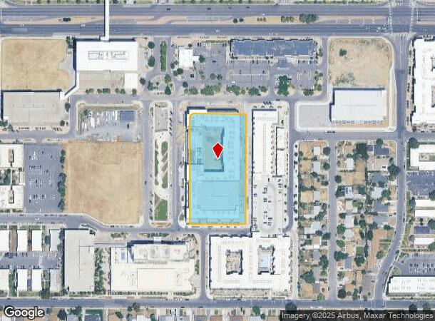
1380 S Uvalda St, Aurora, CO 80011
NEARBY LISTINGS FOR SALE OR LEASE
Property Detail
1380 S Uvalda St
Denver-Aurora-Lakewood, CO
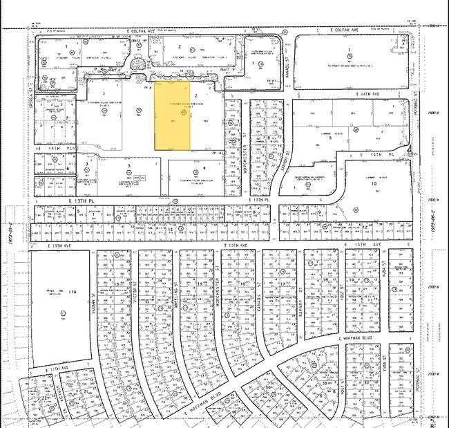
Fitzsimons Village Subdivision Filing No
1973-01-1-40-001
LOT 1 BLK 2 FITZSIMONS VILLAGE SUB FLG NO 3
Apartment
Arapahoe
X
Colorado
08005C0177L
1
2024
2.80 AC
2025
Aurora
007301
Denver
540,166 SF
DEMOGRAPHICS near 1380 S Uvalda St
1 Mile
3 Mile
5 Mile
2024 Total Population
21,877
155,421
392,097
2029 Population
22,414
158,099
397,486
Pop Growth 2024-2029
+ 2.45%
+ 1.72%
+ 1.37%
Average Age
35
35
37
2024 Total Households
7,803
54,435
147,021
HH Growth 2024-2029
+ 2.97%
+ 1.80%
+ 1.40%
Median Household Inc
$47,284
$56,986
$68,595
Avg Household Size
2.60
2.70
2.50
2024 Avg HH Vehicles
2.00
2.00
2.00
Median Home Value
$329,644
$356,931
$397,409
Median Year Built
1977
1979
1982
Nearby Places
Map Layers
Map Styles
 Street
 Aerial
- Restaurants
- Banks
- Shops
- Fitness
- Groceries
PUBLIC TRANSPORTATION
COMMUTER RAIL
DRIVE
WALK
Distance
8 min
3.8 mi
DRIVE
WALK
Distance
8 min
3.8 mi
AIRPORT
Denver International
DRIVE
WALK
Distance
Denver International
22 min
16.2 mi
Nearby Properties
Address
Land Use
TOTAL SIZE
Lot Size
Zoning
Address
Land Use
TOTAL SIZE
Lot Size
Zoning
368,450 SF
48.59 AC
Address
Land Use
TOTAL SIZE
Lot Size
Zoning
353,829 SF
4.51 AC
Address
Land Use
TOTAL SIZE
Lot Size
Zoning
880,442 SF
67.95 AC
I-B
Address
Land Use
TOTAL SIZE
Lot Size
Zoning
525,050 SF
105.06 AC
Address
Land Use
TOTAL SIZE
Lot Size
Zoning
116,490 SF
3.71 AC
PUD
Address
Land Use
TOTAL SIZE
Lot Size
Zoning
140,419 SF
8.37 AC
Address
Land Use
TOTAL SIZE
Lot Size
Zoning
161,437 SF
2.22 AC
RCZDC
Address
Land Use
TOTAL SIZE
Lot Size
Zoning
97,001 SF
Address
Land Use
TOTAL SIZE
Lot Size
Zoning
87,346 SF
1.76 AC
RFBAD
Address
Land Use
TOTAL SIZE
Lot Size
Zoning
691,200 SF
38.09 AC
Address
Land Use
TOTAL SIZE
Lot Size
Zoning
273,184 SF
1.89 AC
Address
Land Use
TOTAL SIZE
Lot Size
Zoning
313,993 SF
5.69 AC
Address
Land Use
TOTAL SIZE
Lot Size
Zoning
390,822 SF
13.47 AC
O-1
Address
Land Use
TOTAL SIZE
Lot Size
Zoning
57,392 SF
0.72 AC
Address
Land Use
TOTAL SIZE
Lot Size
Zoning
140.42 AC
Address
Land Use
TOTAL SIZE
Lot Size
Zoning
557,843 SF
21.35 AC
PUD
Address
Land Use
TOTAL SIZE
Lot Size
Zoning
83,951 SF
0.30 AC
R2
Address
Land Use
TOTAL SIZE
Lot Size
Zoning
315,058 SF
36.85 AC
RPCZD
Address
Land Use
TOTAL SIZE
Lot Size
Zoning
43,568 SF
1.53 AC
Address
Land Use
TOTAL SIZE
Lot Size
Zoning
269,622 SF
12.90 AC
Address
Land Use
TOTAL SIZE
Lot Size
Zoning
277,985 SF
19.07 AC
Address
Land Use
TOTAL SIZE
Lot Size
Zoning
178,235 SF
1.38 AC
RFBAD
Address
Land Use
TOTAL SIZE
Lot Size
Zoning
51,075 SF
0.72 AC
Address
Land Use
TOTAL SIZE
Lot Size
Zoning
238,845 SF
1.70 AC
Address
Land Use
TOTAL SIZE
Lot Size
Zoning
624,019 SF
4.09 AC
Address
Land Use
TOTAL SIZE
Lot Size
Zoning
672,521 SF
0.61 AC
RB3
Address
Land Use
TOTAL SIZE
Lot Size
Zoning
400,000 SF
22.91 AC
I-0
Address
Land Use
TOTAL SIZE
Lot Size
Zoning
176,751 SF
28.75 AC
Address
Land Use
TOTAL SIZE
Lot Size
Zoning
331,923 SF
16.83 AC
Address
Land Use
TOTAL SIZE
Lot Size
Zoning
111,358 SF
1.21 AC
The World's #1 Commercial Real Estate Marketplace
Connect with us
© 2026 CoStar Group
The information above has been obtained from sources believed reliable. While we do not doubt its accuracy we have not verified it and make no guarantee, warranty or representation about it. It is your responsibility to independently confirm its accuracy and completeness. Any projections, opinions, assumptions, or estimates used are for example only and do not represent the current or future performance of the property. The value of this transaction to you depends on tax and other factors which should be evaluated by your tax, financial, and legal advisors. You and your advisors should conduct a careful, independent investigation of the property to determine to your satisfaction the suitability of the property for your needs.