Property Record
1420 Overlook Dr, Lafayette, CO 80026
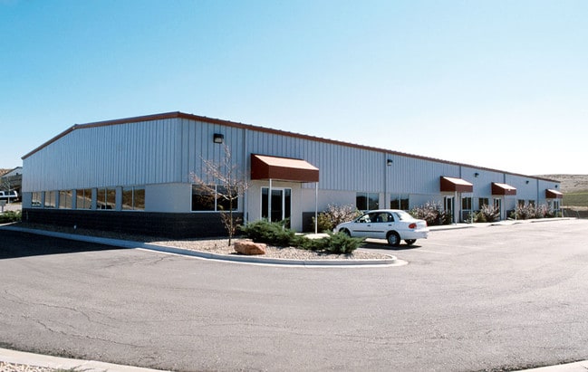
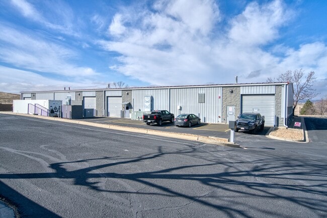

This Property Is For Sale
NEARBY LISTINGS FOR SALE OR LEASE
Property Detail
1420 Overlook Dr
Boulder, CO
Overlook Sub Rplt B
1575120-08-008
LOT 5B OVERLOOK SUB RPLT B
Industrialgeneral
Boulder
X
Colorado
08013C0602K
5b
2024
1.33 AC
2025
Boulder County
060802
Denver
14,320 SF
DEMOGRAPHICS near 1420 Overlook Dr
1 mile
3 mile
5 mile
2024 Total Population
4,513
51,970
169,136
2029 Population
4,563
54,302
178,497
Pop Growth 2024-2029
+ 1.11%
+ 4.49%
+ 5.53%
Average Age
36
41
40
2024 Total Households
1,810
19,849
64,687
HH Growth 2024-2029
+ 1.22%
+ 4.13%
+ 5.42%
Median Household Inc
$82,341
$118,704
$116,399
Avg Household Size
2.40
2.60
2.60
2024 Avg HH Vehicles
2.00
2.00
2.00
Median Home Value
$436,065
$651,055
$649,393
Median Year Built
2010
1998
1997
Nearby Places
Map Layers
Map Styles
 Street
 Aerial
Transit
 Traffic
 Biking
Places
Listings with unknown addresses are not visible on the map
- Restaurants
- Banks
- Shops
- Fitness
- Groceries
PUBLIC TRANSPORTATION
COMMUTER RAIL
Eastlake - 124Th Station Track 2 (Union Station to Eastlake & 124th Station - Regional Transportation District)
Drive
Walk
Distance
Eastlake - 124Th Station Track 2 (Union Station to Eastlake & 124th Station - Regional Transportation District)
19 min
9.9 mi
AIRPORT
Denver International
Drive
Walk
Distance
Denver International
40 min
33.0 mi
Freight Ports
Tulsa Port Of Catoosa
Drive
Walk
Distance
Tulsa Port Of Catoosa
747 min
727.1 mi
Nearby Properties
Address
Land Use
TOTAL SIZE
Lot Size
Zoning
Address
Land Use
TOTAL SIZE
Lot Size
Zoning
420,330 SF
41.96 AC
A
Address
Land Use
TOTAL SIZE
Lot Size
Zoning
62.60 AC
Address
Land Use
TOTAL SIZE
Lot Size
Zoning
190,387 SF
106.32 AC
PUD
Address
Land Use
TOTAL SIZE
Lot Size
Zoning
279.72 AC
A
Address
Land Use
TOTAL SIZE
Lot Size
Zoning
188,092 SF
2.01 AC
Address
Land Use
TOTAL SIZE
Lot Size
Zoning
78,238 SF
181.60 AC
OLPF
Address
Land Use
TOTAL SIZE
Lot Size
Zoning
57.98 AC
A
Address
Land Use
TOTAL SIZE
Lot Size
Zoning
120,510 SF
11.02 AC
Address
Land Use
TOTAL SIZE
Lot Size
Zoning
103,416 SF
45.52 AC
PUD
Address
Land Use
TOTAL SIZE
Lot Size
Zoning
153,430 SF
12.16 AC
Address
Land Use
TOTAL SIZE
Lot Size
Zoning
137,435 SF
9.49 AC
Address
Land Use
TOTAL SIZE
Lot Size
Zoning
214,678 SF
10.46 AC
Address
Land Use
TOTAL SIZE
Lot Size
Zoning
113,473 SF
8.59 AC
Address
Land Use
TOTAL SIZE
Lot Size
Zoning
165,172 SF
11.12 AC
Address
Land Use
TOTAL SIZE
Lot Size
Zoning
136,036 SF
12.87 AC
PUD
Address
Land Use
TOTAL SIZE
Lot Size
Zoning
116.21 AC
A
Address
Land Use
TOTAL SIZE
Lot Size
Zoning
164,842 SF
10.97 AC
Address
Land Use
TOTAL SIZE
Lot Size
Zoning
109,056 SF
7.76 AC
Address
Land Use
TOTAL SIZE
Lot Size
Zoning
119,427 SF
12.75 AC
PUD
Address
Land Use
TOTAL SIZE
Lot Size
Zoning
76,658 SF
6.40 AC
Address
Land Use
TOTAL SIZE
Lot Size
Zoning
67,551 SF
4.27 AC
Address
Land Use
TOTAL SIZE
Lot Size
Zoning
18,900 SF
60.88 AC
PUD
Address
Land Use
TOTAL SIZE
Lot Size
Zoning
138.19 AC
A
Address
Land Use
TOTAL SIZE
Lot Size
Zoning
130,348 SF
8.88 AC
Address
Land Use
TOTAL SIZE
Lot Size
Zoning
91,570 SF
6.09 AC
Address
Land Use
TOTAL SIZE
Lot Size
Zoning
136,448 SF
10.86 AC
Address
Land Use
TOTAL SIZE
Lot Size
Zoning
247,609 SF
14.53 AC
Address
Land Use
TOTAL SIZE
Lot Size
Zoning
132.98 AC
Address
Land Use
TOTAL SIZE
Lot Size
Zoning
109,547 SF
7.91 AC
Address
Land Use
TOTAL SIZE
Lot Size
Zoning
76.96 AC
A
The World's #1 Commercial Real Estate Marketplace
Connect with us
© 2026 CoStar Group
The information above has been obtained from sources believed reliable. While we do not doubt its accuracy we have not verified it and make no guarantee, warranty or representation about it. It is your responsibility to independently confirm its accuracy and completeness. Any projections, opinions, assumptions, or estimates used are for example only and do not represent the current or future performance of the property. The value of this transaction to you depends on tax and other factors which should be evaluated by your tax, financial, and legal advisors. You and your advisors should conduct a careful, independent investigation of the property to determine to your satisfaction the suitability of the property for your needs.