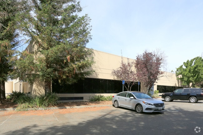
Property Record
1415 N Mcdowell Blvd, Petaluma, CA 94954


Save to a Folder
{{folder.Name}}
{{folder.ListingIds.length}} Properties
{{folder.ListingIds.length}} Property
Create a New Folder
Property Detail
1415 N Mcdowell Blvd
047-360-021
96 FM47-360-12 PM 288 PCL 1
Commercialnec
Sonoma
B and X Area of moderate flood hazard, usually the area between the limits of the 100-year and 500-year floods.
California
2025
0.69 AC
2025
Petaluma/Cotati/Rohnert
151205
North Bay/Santa Rosa
29,900 SF
Santa Rosa-Petaluma, CA
NEARBY LISTINGS FOR SALE OR LEASE
DEMOGRAPHICS near 1415 N Mcdowell Blvd
1 mile
3 mile
5 mile
2025 Total Population
1,061
28,794
101,401
2030 Population
988
28,254
101,049
Pop Growth 2025-2030
(6.88%)
(1.88%)
(0.35%)
Average Age
48
44
42
2025 Total Households
454
11,351
37,984
HH Growth 2025-2030
(6.83%)
(1.89%)
(0.38%)
Median Household Inc
$94,711
$110,896
$106,747
Avg Household Size
2.30
2.50
2.50
2025 Avg HH Vehicles
2.00
2.00
2.00
Median Home Value
$1,047,093
$852,649
$811,998
Median Year Built
1971
1983
1979
Nearby Places
Map Layers
Map Styles
 Street
 Aerial
Layers
 Traffic
 Biking
Places
Listings with unknown addresses are not visible on the map
- Restaurants
- Banks
- Shops
- Fitness
- Groceries
PUBLIC TRANSPORTATION
COMMUTER RAIL
Drive
Walk
Distance
4 min
1.4 mi
Drive
Walk
Distance
8 min
4.3 mi
AIRPORT
Charles M Schulz - Sonoma County
Drive
Walk
Distance
Charles M Schulz - Sonoma County
27 min
20.7 mi
Freight Ports
Port of Richmond
Drive
Walk
Distance
Port of Richmond
49 min
36.3 mi
SALE & LEASE HISTORY
LISTING DATE
SALE/LEASE

Jun 23, 2020
For Lease
Jun 23, 2020
For Sale
Nearby Properties
Address
Land Use
TOTAL SIZE
Lot Size
Zoning
Address
Land Use
TOTAL SIZE
Lot Size
Zoning
226,772 SF
8.05 AC
Address
Land Use
TOTAL SIZE
Lot Size
Zoning
38,083 SF
16.14 AC
Address
Land Use
TOTAL SIZE
Lot Size
Zoning
82,704 SF
14.63 AC
CITYPE
Address
Land Use
TOTAL SIZE
Lot Size
Zoning
83,653 SF
1.18 AC
Address
Land Use
TOTAL SIZE
Lot Size
Zoning
63,959 SF
7.13 AC
Address
Land Use
TOTAL SIZE
Lot Size
Zoning
195,837 SF
16.32 AC
PCD
Address
Land Use
TOTAL SIZE
Lot Size
Zoning
85,582 SF
2.61 AC
CITYPE
Address
Land Use
TOTAL SIZE
Lot Size
Zoning
83,109 SF
9.56 AC
Address
Land Use
TOTAL SIZE
Lot Size
Zoning
20,728 SF
10.36 AC
ML
Address
Land Use
TOTAL SIZE
Lot Size
Zoning
93,700 SF
6.02 AC
ML
Address
Land Use
TOTAL SIZE
Lot Size
Zoning
81,975 SF
5 AC
Address
Land Use
TOTAL SIZE
Lot Size
Zoning
88,482 SF
7.29 AC
Address
Land Use
TOTAL SIZE
Lot Size
Zoning
83,880 SF
5 AC
ML
Address
Land Use
TOTAL SIZE
Lot Size
Zoning
112,240 SF
6.30 AC
PUD
Address
Land Use
TOTAL SIZE
Lot Size
Zoning
5,500 SF
4.70 AC
Address
Land Use
TOTAL SIZE
Lot Size
Zoning
1,614 SF
5.21 AC
RM4
Address
Land Use
TOTAL SIZE
Lot Size
Zoning
32,288 SF
2.59 AC
CITYPE
Address
Land Use
TOTAL SIZE
Lot Size
Zoning
71,884 SF
0.65 AC
Address
Land Use
TOTAL SIZE
Lot Size
Zoning
141,168 SF
9.44 AC
18
Address
Land Use
TOTAL SIZE
Lot Size
Zoning
54,637 SF
0.66 AC
Address
Land Use
TOTAL SIZE
Lot Size
Zoning
51,462 SF
0.90 AC
CITYPE
Address
Land Use
TOTAL SIZE
Lot Size
Zoning
35,864 SF
1.67 AC
PUD
Address
Land Use
TOTAL SIZE
Lot Size
Zoning
90,530 SF
2.61 AC
Address
Land Use
TOTAL SIZE
Lot Size
Zoning
58,299 SF
0.72 AC
Address
Land Use
TOTAL SIZE
Lot Size
Zoning
1,726 SF
1.66 AC
Address
Land Use
TOTAL SIZE
Lot Size
Zoning
18,908 SF
12.69 AC
Address
Land Use
TOTAL SIZE
Lot Size
Zoning
1.69 AC
PUD
Address
Land Use
TOTAL SIZE
Lot Size
Zoning
44,244 SF
3.44 AC
Address
Land Use
TOTAL SIZE
Lot Size
Zoning
23,022 SF
1.68 AC
The World's #1 Commercial Real Estate Marketplace
Connect with us
© 2026 CoStar Group
The information above has been obtained from sources believed reliable. While we do not doubt its accuracy we have not verified it and make no guarantee, warranty or representation about it. It is your responsibility to independently confirm its accuracy and completeness. Any projections, opinions, assumptions, or estimates used are for example only and do not represent the current or future performance of the property. The value of this transaction to you depends on tax and other factors which should be evaluated by your tax, financial, and legal advisors. You and your advisors should conduct a careful, independent investigation of the property to determine to your satisfaction the suitability of the property for your needs.