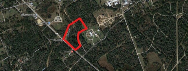
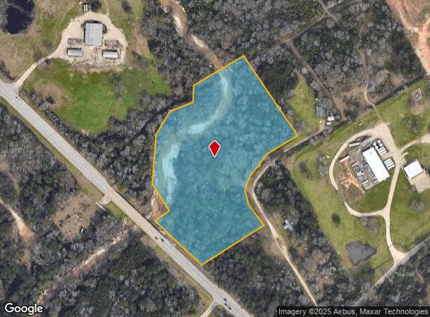
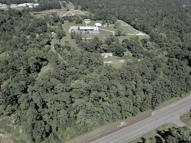
Property Record
14657 Fm 1314 Rd, Conroe, TX 77302
NEARBY LISTINGS FOR SALE OR LEASE
Property Detail
14657 Fm 1314 Rd
Houston-Pasadena-The Woodlands, TX
Smith Lemuel
0502-00-00725
A0502 SMITH LEMUEL, TRACT 7-H, ACRES 7.060
Vacantlandnec
Montgomery
AE
Texas
48339C0535G
7.06 AC
2024
Outlying Montgomery Cnty
2025
Houston
692202
DEMOGRAPHICS near 14657 Fm 1314 Rd
1 Mile
3 Mile
5 Mile
2024 Total Population
839
7,028
52,501
2029 Population
1,036
8,681
64,888
Pop Growth 2024-2029
+ 23.48%
+ 23.52%
+ 23.59%
Average Age
39
37
37
2024 Total Households
291
2,308
17,544
HH Growth 2024-2029
+ 23.71%
+ 23.74%
+ 23.80%
Median Household Inc
$39,749
$77,570
$86,291
Avg Household Size
2.80
3.00
2.90
2024 Avg HH Vehicles
2.00
2.00
2.00
Median Home Value
$192,104
$226,530
$259,661
Median Year Built
2000
2000
2005
Nearby Places
Map Layers
Map Styles
 Street
 Aerial
- Restaurants
- Banks
- Shops
- Fitness
- Groceries
PUBLIC TRANSPORTATION
AIRPORT
George Bush Intcntl/Houston
DRIVE
WALK
Distance
George Bush Intcntl/Houston
43 min
32.4 mi
Freight Ports
Port of Houston
DRIVE
WALK
Distance
Port of Houston
66 min
48.1 mi
SALE & LEASE HISTORY
LISTING DATE
SALE/LEASE

Apr 24, 2022
For Sale
Nearby Properties
Address
Land Use
TOTAL SIZE
Lot Size
Zoning
Address
Land Use
TOTAL SIZE
Lot Size
Zoning
90,180 SF
3.22 AC
1
Address
Land Use
TOTAL SIZE
Lot Size
Zoning
23,912 SF
53.69 AC
1
Address
Land Use
TOTAL SIZE
Lot Size
Zoning
32,009 SF
13.32 AC
1
Address
Land Use
TOTAL SIZE
Lot Size
Zoning
6,286 SF
21.84 AC
Address
Land Use
TOTAL SIZE
Lot Size
Zoning
16,996 SF
6.50 AC
1
Address
Land Use
TOTAL SIZE
Lot Size
Zoning
9,100 SF
3.08 AC
1
Address
Land Use
TOTAL SIZE
Lot Size
Zoning
28,575 SF
10.19 AC
Address
Land Use
TOTAL SIZE
Lot Size
Zoning
32,341 SF
4.64 AC
1
Address
Land Use
TOTAL SIZE
Lot Size
Zoning
20,091 SF
12.04 AC
1
Address
Land Use
TOTAL SIZE
Lot Size
Zoning
15,600 SF
4.92 AC
Address
Land Use
TOTAL SIZE
Lot Size
Zoning
25,050 SF
9.70 AC
1
Address
Land Use
TOTAL SIZE
Lot Size
Zoning
62,127 SF
9.93 AC
1
Address
Land Use
TOTAL SIZE
Lot Size
Zoning
9,000 SF
3.46 AC
6
Address
Land Use
TOTAL SIZE
Lot Size
Zoning
26,310 SF
6.50 AC
1
Address
Land Use
TOTAL SIZE
Lot Size
Zoning
16,701 SF
3.06 AC
1
Address
Land Use
TOTAL SIZE
Lot Size
Zoning
7,914 SF
3.24 AC
6
Address
Land Use
TOTAL SIZE
Lot Size
Zoning
12,388 SF
1.01 AC
6
Address
Land Use
TOTAL SIZE
Lot Size
Zoning
10,440 SF
7.01 AC
1
Address
Land Use
TOTAL SIZE
Lot Size
Zoning
9,000 SF
35.22 AC
1
Address
Land Use
TOTAL SIZE
Lot Size
Zoning
2,688 SF
1.91 AC
6
Address
Land Use
TOTAL SIZE
Lot Size
Zoning
1,801 SF
5.63 AC
1
Address
Land Use
TOTAL SIZE
Lot Size
Zoning
14,993 SF
2.38 AC
1
Address
Land Use
TOTAL SIZE
Lot Size
Zoning
8,286 SF
50.33 AC
6
Address
Land Use
TOTAL SIZE
Lot Size
Zoning
17,400 SF
2.57 AC
1
Address
Land Use
TOTAL SIZE
Lot Size
Zoning
5,000 SF
5.10 AC
Address
Land Use
TOTAL SIZE
Lot Size
Zoning
11,858 SF
1.24 AC
6
Address
Land Use
TOTAL SIZE
Lot Size
Zoning
10,038 SF
1.23 AC
1
Address
Land Use
TOTAL SIZE
Lot Size
Zoning
10,038 SF
2.04 AC
1
Address
Land Use
TOTAL SIZE
Lot Size
Zoning
10,000 SF
2.54 AC
The World's #1 Commercial Real Estate Marketplace
Connect with us
© 2026 CoStar Group
The information above has been obtained from sources believed reliable. While we do not doubt its accuracy we have not verified it and make no guarantee, warranty or representation about it. It is your responsibility to independently confirm its accuracy and completeness. Any projections, opinions, assumptions, or estimates used are for example only and do not represent the current or future performance of the property. The value of this transaction to you depends on tax and other factors which should be evaluated by your tax, financial, and legal advisors. You and your advisors should conduct a careful, independent investigation of the property to determine to your satisfaction the suitability of the property for your needs.