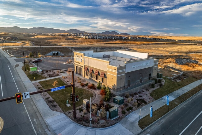
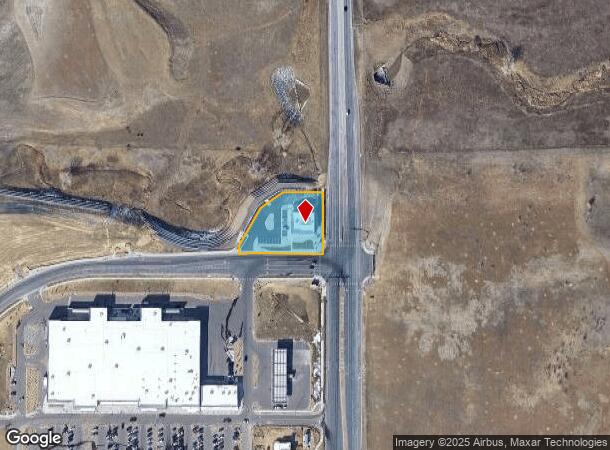
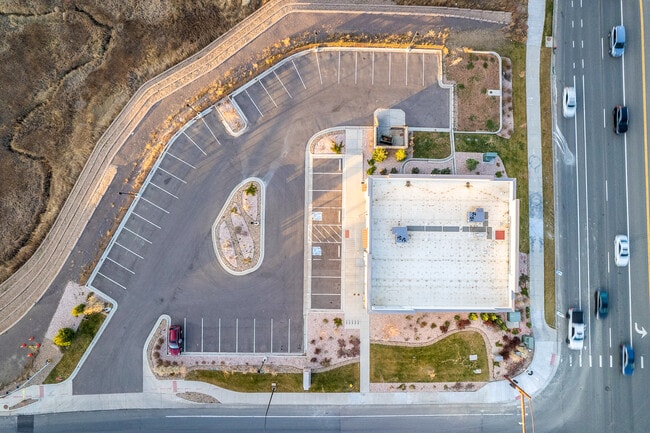
Property Record
14823 W 91St Pl, Arvada, CO 80007

NEARBY LISTINGS FOR SALE OR LEASE
-
-
View all Arvada listings for sale on LoopNet.com
Property Detail
14823 W 91St Pl
Denver-Aurora-Centennial, CO
Candelas Commercial Flg No 3
20-244-03-001
SECTION 24 TOWNSHIP 02 RANGE 70 SUBDIVISIONCD 108024 SUBDIVISIONNAME CANDELAS COMMERCIAL FLG NO 3 BLOCK 001 LOT 0006 SIZE: 38023 VALUE: .873
Commercialnec
Jefferson
X
Colorado
08059C0360F
6
2023
0.87 AC
2024
West Denver
060501
Denver
3,596 SF
DEMOGRAPHICS near 14823 W 91St Pl
1 mile
3 mile
5 mile
2024 Total Population
3,627
32,199
122,437
2029 Population
3,621
31,846
121,503
Pop Growth 2024-2029
(0.17%)
(1.10%)
(0.76%)
Average Age
39
41
41
2024 Total Households
1,209
11,389
48,174
HH Growth 2024-2029
(0.41%)
(1.13%)
(0.57%)
Median Household Inc
$165,671
$144,897
$111,889
Avg Household Size
3.00
2.80
2.50
2024 Avg HH Vehicles
2.00
2.00
2.00
Median Home Value
$721,967
$693,710
$617,776
Median Year Built
2011
1999
1987
Nearby Places
Map Layers
Map Styles
 Street
 Aerial
Transit
 Traffic
 Biking
Places
Listings with unknown addresses are not visible on the map
- Restaurants
- Banks
- Shops
- Fitness
- Groceries
PUBLIC TRANSPORTATION
COMMUTER RAIL
Wheat Ridge - Ward Station Track 1 (Union Station to Wheat Ridge Ward Station - Regional Transportation District)
Drive
Walk
Distance
Wheat Ridge - Ward Station Track 1 (Union Station to Wheat Ridge Ward Station - Regional Transportation District)
12 min
6.9 mi
Arvada Ridge Station Track 1 (Union Station to Wheat Ridge Ward Station - Regional Transportation District)
Drive
Walk
Distance
Arvada Ridge Station Track 1 (Union Station to Wheat Ridge Ward Station - Regional Transportation District)
13 min
7.7 mi
AIRPORT
Denver International
Drive
Walk
Distance
Denver International
47 min
39.9 mi
Freight Ports
Tulsa Port Of Catoosa
Drive
Walk
Distance
Tulsa Port Of Catoosa
746 min
720.5 mi
SALE & LEASE HISTORY
LISTING DATE
SALE/LEASE

May 20, 2019
For Sale
Dec 08, 2023
For Sale
Nearby Properties
Address
Land Use
TOTAL SIZE
Lot Size
Zoning
Address
Land Use
TOTAL SIZE
Lot Size
Zoning
253,643 SF
50.87 AC
A2
Address
Land Use
TOTAL SIZE
Lot Size
Zoning
1,968.53 AC
Address
Land Use
TOTAL SIZE
Lot Size
Zoning
215,878 SF
11.82 AC
A2
Address
Land Use
TOTAL SIZE
Lot Size
Zoning
170,218 SF
18.80 AC
PUD
Address
Land Use
TOTAL SIZE
Lot Size
Zoning
131,170 SF
10.56 AC
Address
Land Use
TOTAL SIZE
Lot Size
Zoning
68,300 SF
6 AC
Address
Land Use
TOTAL SIZE
Lot Size
Zoning
110,235 SF
2.32 AC
Address
Land Use
TOTAL SIZE
Lot Size
Zoning
53,051 SF
70.19 AC
I2
Address
Land Use
TOTAL SIZE
Lot Size
Zoning
121,192 SF
12.43 AC
Address
Land Use
TOTAL SIZE
Lot Size
Zoning
95,412 SF
5.32 AC
Address
Land Use
TOTAL SIZE
Lot Size
Zoning
44,797 SF
4.35 AC
Address
Land Use
TOTAL SIZE
Lot Size
Zoning
8,856 SF
41.91 AC
Address
Land Use
TOTAL SIZE
Lot Size
Zoning
89,535 SF
2.88 AC
Address
Land Use
TOTAL SIZE
Lot Size
Zoning
97,803 SF
10.02 AC
Address
Land Use
TOTAL SIZE
Lot Size
Zoning
441 AC
PD
Address
Land Use
TOTAL SIZE
Lot Size
Zoning
50,529 SF
23.88 AC
Address
Land Use
TOTAL SIZE
Lot Size
Zoning
53,400 SF
6.40 AC
Address
Land Use
TOTAL SIZE
Lot Size
Zoning
320 AC
A2
Address
Land Use
TOTAL SIZE
Lot Size
Zoning
41,106 SF
4.86 AC
PUD
Address
Land Use
TOTAL SIZE
Lot Size
Zoning
85.97 AC
A2
Address
Land Use
TOTAL SIZE
Lot Size
Zoning
295.40 AC
Address
Land Use
TOTAL SIZE
Lot Size
Zoning
23,906 SF
1.14 AC
Address
Land Use
TOTAL SIZE
Lot Size
Zoning
13,180 SF
2.86 AC
Address
Land Use
TOTAL SIZE
Lot Size
Zoning
13,050 SF
1.37 AC
Address
Land Use
TOTAL SIZE
Lot Size
Zoning
10,886 SF
1.47 AC
Address
Land Use
TOTAL SIZE
Lot Size
Zoning
14,677 SF
2.20 AC
Address
Land Use
TOTAL SIZE
Lot Size
Zoning
224.74 AC
Address
Land Use
TOTAL SIZE
Lot Size
Zoning
28,308 SF
10.53 AC
MR1
Address
Land Use
TOTAL SIZE
Lot Size
Zoning
35,672 SF
3.25 AC
PUD
Address
Land Use
TOTAL SIZE
Lot Size
Zoning
12,789 SF
1.83 AC
The World's #1 Commercial Real Estate Marketplace
Connect with us
© 2026 CoStar Group
The information above has been obtained from sources believed reliable. While we do not doubt its accuracy we have not verified it and make no guarantee, warranty or representation about it. It is your responsibility to independently confirm its accuracy and completeness. Any projections, opinions, assumptions, or estimates used are for example only and do not represent the current or future performance of the property. The value of this transaction to you depends on tax and other factors which should be evaluated by your tax, financial, and legal advisors. You and your advisors should conduct a careful, independent investigation of the property to determine to your satisfaction the suitability of the property for your needs.