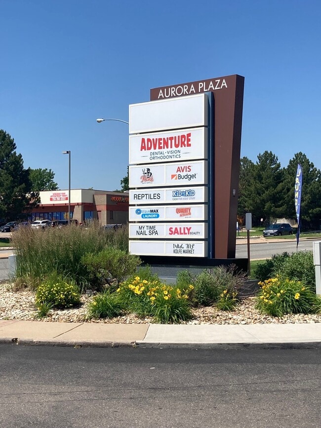
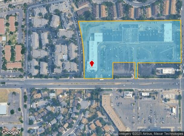
Property Record
15001 E Mississippi Ave, Aurora, CO 80012

NEARBY LISTINGS FOR SALE OR LEASE
Property Detail
15001 E Mississippi Ave
Denver
Marshall's Aurora Plaza Subdivision Fili
Denver-Aurora-Lakewood, CO
TOWNSHIP T4S MAPPLATB E302 MAPPLATP 9238 SUBDIVISIONCD 043741 SUBDIVISIONNAME MARSHALLS AURORA PLAZA SUBDIVISION FILING NO 2 BLOCK 001 LOT 004 LOT 4 BLK 1 MARSHALLS AURORA PLAZA SUB FLG #2
1975-18-4-43-004
Arapahoe
Storebuilding
Colorado
0
4
2024
10.60 AC
081102
Aurora
129,735 SF
DEMOGRAPHICS near 15001 E Mississippi Ave
1 Mile
3 Mile
5 Mile
2024 Total Population
24,978
169,222
389,785
2029 Population
25,197
169,871
393,817
Pop Growth 2024-2029
+ 0.88%
+ 0.38%
+ 1.03%
Average Age
36
38
38
2024 Total Households
9,668
64,675
151,149
HH Growth 2024-2029
+ 1.01%
+ 0.44%
+ 1.07%
Median Household Inc
$64,712
$64,255
$65,600
Avg Household Size
2.50
2.50
2.50
2024 Avg HH Vehicles
2.00
2.00
2.00
Median Home Value
$332,818
$360,541
$378,218
Median Year Built
1983
1981
1982
Nearby Places
Map Layers
Map Styles
 Street
 Aerial
- Restaurants
- Banks
- Shops
- Fitness
- Groceries
PUBLIC TRANSPORTATION
COMMUTER RAIL
Peoria Station Track 1 (Union Station to Denver Airport Station - Regional Transportation District)
DRIVE
WALK
Distance
Peoria Station Track 1 (Union Station to Denver Airport Station - Regional Transportation District)
11 min
7.7 mi
40Th Ave & Airport Blvd - Gateway Park Station Track 2 (Union Station to Denver Airport Station - Regional Transportation District)
DRIVE
WALK
Distance
40Th Ave & Airport Blvd - Gateway Park Station Track 2 (Union Station to Denver Airport Station - Regional Transportation District)
14 min
8.9 mi
AIRPORT
Denver International
DRIVE
WALK
Distance
Denver International
24 min
19.4 mi
Freight Ports
Tulsa Port Of Catoosa
DRIVE
WALK
Distance
Tulsa Port Of Catoosa
721 min
702.2 mi
SALE & LEASE HISTORY
LISTING DATE
SALE/LEASE

Sep 24, 2016
For Lease
Jun 11, 2025
For Lease
Feb 24, 2020
For Sale
Dec 12, 2019
For Lease
Nearby Properties
Address
Land Use
TOTAL SIZE
Lot Size
Zoning
Address
Land Use
TOTAL SIZE
Lot Size
Zoning
496,493 SF
33.45 AC
Address
Land Use
TOTAL SIZE
Lot Size
Zoning
476,186 SF
42.62 AC
Address
Land Use
TOTAL SIZE
Lot Size
Zoning
277,940 SF
31.61 AC
Address
Land Use
TOTAL SIZE
Lot Size
Zoning
140.42 AC
Address
Land Use
TOTAL SIZE
Lot Size
Zoning
315,058 SF
36.85 AC
RPCZD
Address
Land Use
TOTAL SIZE
Lot Size
Zoning
277,985 SF
19.07 AC
Address
Land Use
TOTAL SIZE
Lot Size
Zoning
201,600 SF
44.67 AC
R1
Address
Land Use
TOTAL SIZE
Lot Size
Zoning
130,531 SF
3.41 AC
Address
Land Use
TOTAL SIZE
Lot Size
Zoning
364,024 SF
23.23 AC
PUD
Address
Land Use
TOTAL SIZE
Lot Size
Zoning
220,395 SF
7.93 AC
Address
Land Use
TOTAL SIZE
Lot Size
Zoning
366,800 SF
20.21 AC
Address
Land Use
TOTAL SIZE
Lot Size
Zoning
186,088 SF
10.15 AC
RZIND
Address
Land Use
TOTAL SIZE
Lot Size
Zoning
176,751 SF
28.75 AC
Address
Land Use
TOTAL SIZE
Lot Size
Zoning
462,048 SF
5.34 AC
RB3
Address
Land Use
TOTAL SIZE
Lot Size
Zoning
521,364 SF
14.88 AC
PUD
Address
Land Use
TOTAL SIZE
Lot Size
Zoning
649,712 SF
47.31 AC
Address
Land Use
TOTAL SIZE
Lot Size
Zoning
328,315 SF
8.15 AC
Address
Land Use
TOTAL SIZE
Lot Size
Zoning
105,809 SF
48.79 AC
Address
Land Use
TOTAL SIZE
Lot Size
Zoning
127,530 SF
20.76 AC
Address
Land Use
TOTAL SIZE
Lot Size
Zoning
215,175 SF
28.07 AC
Address
Land Use
TOTAL SIZE
Lot Size
Zoning
114,539 SF
5.35 AC
Address
Land Use
TOTAL SIZE
Lot Size
Zoning
345,688 SF
15.15 AC
PUD
Address
Land Use
TOTAL SIZE
Lot Size
Zoning
145,510 SF
9.61 AC
Address
Land Use
TOTAL SIZE
Lot Size
Zoning
135,050 SF
19.38 AC
Address
Land Use
TOTAL SIZE
Lot Size
Zoning
398,436 SF
28.13 AC
Address
Land Use
TOTAL SIZE
Lot Size
Zoning
146,784 SF
10.58 AC
Address
Land Use
TOTAL SIZE
Lot Size
Zoning
92,228 SF
12.39 AC
PUD
Address
Land Use
TOTAL SIZE
Lot Size
Zoning
187,528 SF
6.15 AC
Address
Land Use
TOTAL SIZE
Lot Size
Zoning
265,326 SF
12.31 AC
RAOD
The World's #1 Commercial Real Estate Marketplace
Connect with us
© 2025 CoStar Group
The information above has been obtained from sources believed reliable. While we do not doubt its accuracy we have not verified it and make no guarantee, warranty or representation about it. It is your responsibility to independently confirm its accuracy and completeness. Any projections, opinions, assumptions, or estimates used are for example only and do not represent the current or future performance of the property. The value of this transaction to you depends on tax and other factors which should be evaluated by your tax, financial, and legal advisors. You and your advisors should conduct a careful, independent investigation of the property to determine to your satisfaction the suitability of the property for your needs.