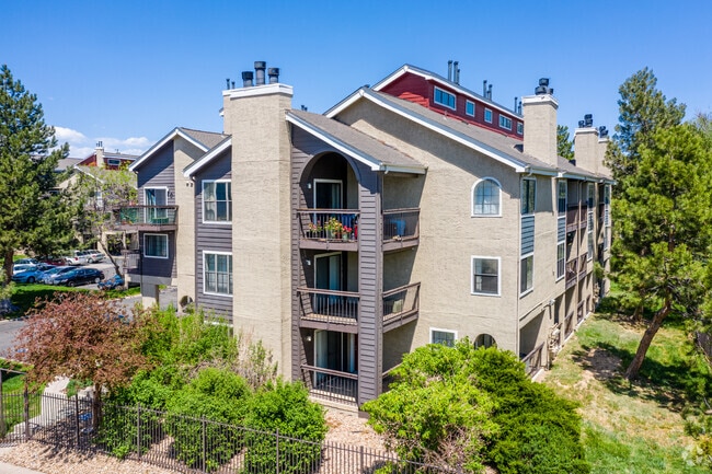
Property Record
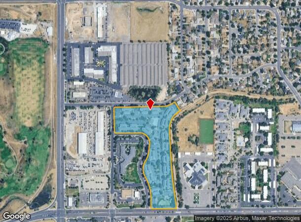
151 S Joliet Cir, Aurora, CO 80012


NEARBY LISTINGS FOR SALE OR LEASE
Property Detail
151 S Joliet Cir
Denver-Aurora-Lakewood, CO
Aurora Highline Sub 1St Flg
1973-11-3-23-001
SUBDIVISIONCD 002548 SUBDIVISIONNAME AURORA HIGHLINE SUB 1ST FLG BLOCK 003 LOT 001 LOT 1 BLK 3 AURORA HIGHLINE SUB 1ST FLG
Apartment
Arapahoe
AE
Colorado
08005C0178K
001,1
2023
11.69 AC
2024
Highline Villages
007703
Denver
264,744 SF
DEMOGRAPHICS near 151 S Joliet Cir
1 Mile
3 Mile
5 Mile
2024 Total Population
25,118
212,546
466,540
2029 Population
25,540
216,210
472,432
Pop Growth 2024-2029
+ 1.68%
+ 1.72%
+ 1.26%
Average Age
36
37
38
2024 Total Households
9,499
85,699
192,859
HH Growth 2024-2029
+ 1.54%
+ 1.76%
+ 1.24%
Median Household Inc
$54,384
$60,740
$68,859
Avg Household Size
2.50
2.40
2.30
2024 Avg HH Vehicles
2.00
2.00
2.00
Median Home Value
$353,726
$392,286
$450,951
Median Year Built
1977
1980
1978
Nearby Places
Map Layers
Map Styles
 Street
 Aerial
- Restaurants
- Banks
- Shops
- Fitness
- Groceries
PUBLIC TRANSPORTATION
COMMUTER RAIL
Peoria Station Track 1 (Union Station to Denver Airport Station - Regional Transportation District)
DRIVE
WALK
Distance
Peoria Station Track 1 (Union Station to Denver Airport Station - Regional Transportation District)
11 min
5.0 mi
Peoria Station Track 2 (Union Station to Denver Airport Station - Regional Transportation District)
DRIVE
WALK
Distance
Peoria Station Track 2 (Union Station to Denver Airport Station - Regional Transportation District)
11 min
5.1 mi
AIRPORT
Denver International
DRIVE
WALK
Distance
Denver International
27 min
19.3 mi
Freight Ports
Tulsa Port Of Catoosa
DRIVE
WALK
Distance
Tulsa Port Of Catoosa
723 min
702.0 mi
Nearby Properties
Address
Land Use
TOTAL SIZE
Lot Size
Zoning
Address
Land Use
TOTAL SIZE
Lot Size
Zoning
368,450 SF
48.59 AC
Address
Land Use
TOTAL SIZE
Lot Size
Zoning
353,829 SF
4.51 AC
Address
Land Use
TOTAL SIZE
Lot Size
Zoning
525,050 SF
105.06 AC
Address
Land Use
TOTAL SIZE
Lot Size
Zoning
496,493 SF
33.45 AC
Address
Land Use
TOTAL SIZE
Lot Size
Zoning
273,184 SF
1.89 AC
Address
Land Use
TOTAL SIZE
Lot Size
Zoning
476,186 SF
42.62 AC
Address
Land Use
TOTAL SIZE
Lot Size
Zoning
315,058 SF
36.85 AC
RPCZD
Address
Land Use
TOTAL SIZE
Lot Size
Zoning
672,521 SF
0.61 AC
RB3
Address
Land Use
TOTAL SIZE
Lot Size
Zoning
384,886 SF
18.66 AC
R-2-A
Address
Land Use
TOTAL SIZE
Lot Size
Zoning
277,985 SF
19.07 AC
Address
Land Use
TOTAL SIZE
Lot Size
Zoning
178,235 SF
1.38 AC
RFBAD
Address
Land Use
TOTAL SIZE
Lot Size
Zoning
201,600 SF
44.67 AC
R1
Address
Land Use
TOTAL SIZE
Lot Size
Zoning
380,376 SF
24.52 AC
E-SU-DX
Address
Land Use
TOTAL SIZE
Lot Size
Zoning
368,676 SF
17.71 AC
R-2-A
Address
Land Use
TOTAL SIZE
Lot Size
Zoning
478,994 SF
26.07 AC
Address
Land Use
TOTAL SIZE
Lot Size
Zoning
540,380 SF
26.03 AC
RR3
Address
Land Use
TOTAL SIZE
Lot Size
Zoning
551,531 SF
5.09 AC
C-MX
Address
Land Use
TOTAL SIZE
Lot Size
Zoning
111,358 SF
1.21 AC
Address
Land Use
TOTAL SIZE
Lot Size
Zoning
102,833 SF
14.27 AC
R-MU-20
Address
Land Use
TOTAL SIZE
Lot Size
Zoning
107,627 SF
1.59 AC
C-MX-5
Address
Land Use
TOTAL SIZE
Lot Size
Zoning
220,395 SF
7.93 AC
Address
Land Use
TOTAL SIZE
Lot Size
Zoning
386,285 SF
2.72 AC
Address
Land Use
TOTAL SIZE
Lot Size
Zoning
154,808 SF
16.71 AC
S-SU-D
Address
Land Use
TOTAL SIZE
Lot Size
Zoning
366,800 SF
20.21 AC
Address
Land Use
TOTAL SIZE
Lot Size
Zoning
327,476 SF
7.91 AC
R-3-X
Address
Land Use
TOTAL SIZE
Lot Size
Zoning
94,638 SF
10.24 AC
R-MU-20
Address
Land Use
TOTAL SIZE
Lot Size
Zoning
244,350 SF
9.59 AC
S-MU-5
Address
Land Use
TOTAL SIZE
Lot Size
Zoning
624,019 SF
4.09 AC
Address
Land Use
TOTAL SIZE
Lot Size
Zoning
96,953 SF
14.54 AC
R-2-A
The World's #1 Commercial Real Estate Marketplace
Connect with us
© 2025 CoStar Group
The information above has been obtained from sources believed reliable. While we do not doubt its accuracy we have not verified it and make no guarantee, warranty or representation about it. It is your responsibility to independently confirm its accuracy and completeness. Any projections, opinions, assumptions, or estimates used are for example only and do not represent the current or future performance of the property. The value of this transaction to you depends on tax and other factors which should be evaluated by your tax, financial, and legal advisors. You and your advisors should conduct a careful, independent investigation of the property to determine to your satisfaction the suitability of the property for your needs.