Property Record
15389 W 91St Dr, Arvada, CO 80007
Current Lease Availabilities
NEARBY LISTINGS FOR SALE OR LEASE
-
-
View all Arvada listings for lease on LoopNet.com
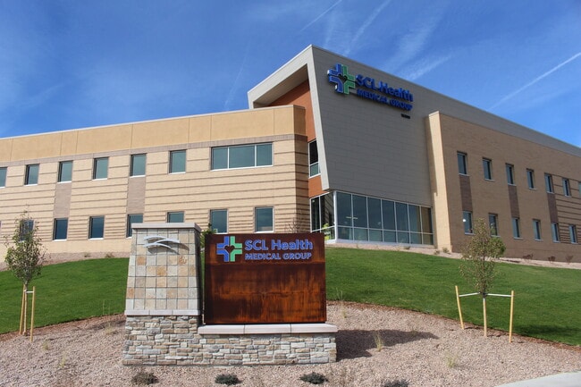
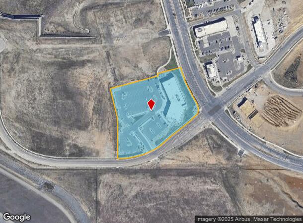
Property Detail
15389 W 91St Dr
Denver-Aurora-Centennial, CO
Candelas Medical Filing No 1
20-244-05-003
SECTION 24 TOWNSHIP 02 RANGE 70 SUBDIVISIONCD 108151 SUBDIVISIONNAME CANDELAS MEDICAL FLG NO 1 AMD NO 1 BLOCK 002 LOT 002A SIZE: 189559 VALUE: 4.352
Commercialnec
Jefferson
X
Colorado
08059C0179F
2a
2023
4.35 AC
2024
West Denver
060501
Denver
44,797 SF
DEMOGRAPHICS near 15389 W 91St Dr
1 mile
3 mile
5 mile
2024 Total Population
3,850
30,090
112,793
2029 Population
3,845
29,823
111,609
Pop Growth 2024-2029
(0.13%)
(0.89%)
(1.05%)
Average Age
38
40
42
2024 Total Households
1,262
10,531
43,702
HH Growth 2024-2029
(0.32%)
(0.92%)
(0.97%)
Median Household Inc
$166,382
$148,147
$115,709
Avg Household Size
3.00
2.80
2.50
2024 Avg HH Vehicles
2.00
2.00
2.00
Median Home Value
$736,519
$717,799
$621,672
Median Year Built
2011
2004
1987
Nearby Places
Map Layers
Map Styles
 Street
 Aerial
Transit
 Traffic
 Biking
Places
Listings with unknown addresses are not visible on the map
- Restaurants
- Banks
- Shops
- Fitness
- Groceries
PUBLIC TRANSPORTATION
COMMUTER RAIL
Wheat Ridge - Ward Station Track 1 (Union Station to Wheat Ridge Ward Station - Regional Transportation District)
Drive
Walk
Distance
Wheat Ridge - Ward Station Track 1 (Union Station to Wheat Ridge Ward Station - Regional Transportation District)
14 min
7.2 mi
Arvada Ridge Station Track 1 (Union Station to Wheat Ridge Ward Station - Regional Transportation District)
Drive
Walk
Distance
Arvada Ridge Station Track 1 (Union Station to Wheat Ridge Ward Station - Regional Transportation District)
14 min
8.0 mi
AIRPORT
Denver International
Drive
Walk
Distance
Denver International
49 min
40.6 mi
Freight Ports
Tulsa Port Of Catoosa
Drive
Walk
Distance
Tulsa Port Of Catoosa
747 min
720.8 mi
Nearby Properties
Address
Land Use
TOTAL SIZE
Lot Size
Zoning
Address
Land Use
TOTAL SIZE
Lot Size
Zoning
253,643 SF
50.87 AC
A2
Address
Land Use
TOTAL SIZE
Lot Size
Zoning
1,968.53 AC
Address
Land Use
TOTAL SIZE
Lot Size
Zoning
215,878 SF
11.82 AC
A2
Address
Land Use
TOTAL SIZE
Lot Size
Zoning
68,300 SF
6 AC
Address
Land Use
TOTAL SIZE
Lot Size
Zoning
110,235 SF
2.32 AC
Address
Land Use
TOTAL SIZE
Lot Size
Zoning
53,051 SF
70.19 AC
I2
Address
Land Use
TOTAL SIZE
Lot Size
Zoning
121,192 SF
12.43 AC
Address
Land Use
TOTAL SIZE
Lot Size
Zoning
95,412 SF
5.32 AC
Address
Land Use
TOTAL SIZE
Lot Size
Zoning
89,535 SF
2.88 AC
Address
Land Use
TOTAL SIZE
Lot Size
Zoning
97,803 SF
10.02 AC
Address
Land Use
TOTAL SIZE
Lot Size
Zoning
441 AC
PD
Address
Land Use
TOTAL SIZE
Lot Size
Zoning
50,529 SF
23.88 AC
Address
Land Use
TOTAL SIZE
Lot Size
Zoning
43,403 SF
34.07 AC
Address
Land Use
TOTAL SIZE
Lot Size
Zoning
53,400 SF
6.40 AC
Address
Land Use
TOTAL SIZE
Lot Size
Zoning
320 AC
A2
Address
Land Use
TOTAL SIZE
Lot Size
Zoning
295.40 AC
Address
Land Use
TOTAL SIZE
Lot Size
Zoning
23,906 SF
1.14 AC
Address
Land Use
TOTAL SIZE
Lot Size
Zoning
37,296 SF
8.45 AC
PD
Address
Land Use
TOTAL SIZE
Lot Size
Zoning
13,180 SF
2.86 AC
Address
Land Use
TOTAL SIZE
Lot Size
Zoning
13,050 SF
1.37 AC
Address
Land Use
TOTAL SIZE
Lot Size
Zoning
10,886 SF
1.47 AC
Address
Land Use
TOTAL SIZE
Lot Size
Zoning
14,677 SF
2.20 AC
Address
Land Use
TOTAL SIZE
Lot Size
Zoning
224.74 AC
Address
Land Use
TOTAL SIZE
Lot Size
Zoning
27,000 SF
1.95 AC
Address
Land Use
TOTAL SIZE
Lot Size
Zoning
28,308 SF
10.53 AC
MR1
Address
Land Use
TOTAL SIZE
Lot Size
Zoning
12,789 SF
1.83 AC
Address
Land Use
TOTAL SIZE
Lot Size
Zoning
5,672 SF
1.34 AC
Address
Land Use
TOTAL SIZE
Lot Size
Zoning
11,567 SF
1.37 AC
Address
Land Use
TOTAL SIZE
Lot Size
Zoning
40,600 SF
4.24 AC
I2
The World's #1 Commercial Real Estate Marketplace
Connect with us
© 2026 CoStar Group
The information above has been obtained from sources believed reliable. While we do not doubt its accuracy we have not verified it and make no guarantee, warranty or representation about it. It is your responsibility to independently confirm its accuracy and completeness. Any projections, opinions, assumptions, or estimates used are for example only and do not represent the current or future performance of the property. The value of this transaction to you depends on tax and other factors which should be evaluated by your tax, financial, and legal advisors. You and your advisors should conduct a careful, independent investigation of the property to determine to your satisfaction the suitability of the property for your needs.