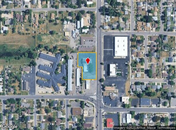
Property Record
155 Sheridan Blvd, Lakewood, CO 80226
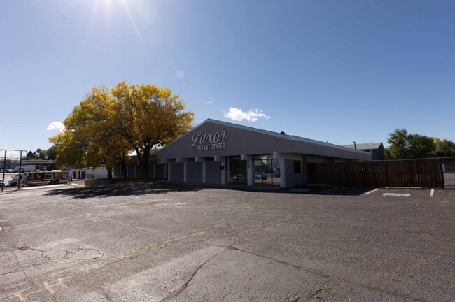
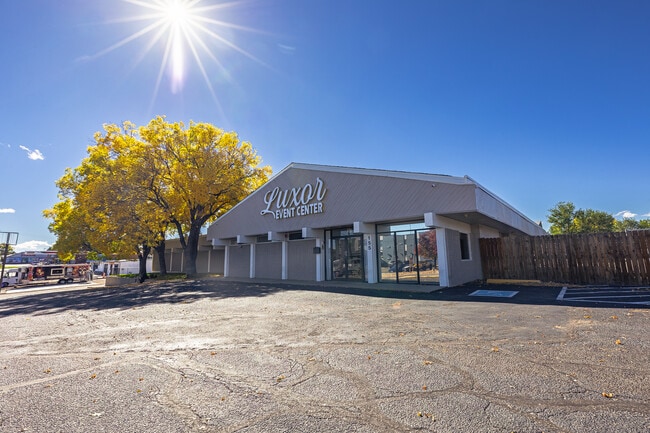
This Property Is For Sale
NEARBY LISTINGS FOR SALE OR LEASE
Property Detail
155 Sheridan Blvd
49-121-00-101
Acreage
Commercialnec
SECTION 12 TOWNSHIP 04 RANGE 69 QTR NE SIZE: 48110 VALUE: 1.104 KEY=203
AE
Jefferson
0800460181H
Colorado
2023
1.10 AC
2024
West
011601
Denver
13,930 SF
Denver-Aurora-Lakewood, CO
DEMOGRAPHICS near 155 Sheridan Blvd
1 Mile
3 Mile
5 Mile
2024 Total Population
21,764
168,096
480,801
2029 Population
21,699
168,353
484,060
Pop Growth 2024-2029
(0.30%)
+ 0.15%
+ 0.68%
Average Age
37
38
39
2024 Total Households
7,835
66,551
222,454
HH Growth 2024-2029
(0.40%)
+ 0.17%
+ 0.83%
Median Household Inc
$50,618
$65,782
$78,797
Avg Household Size
2.60
2.40
2.10
2024 Avg HH Vehicles
2.00
2.00
2.00
Median Home Value
$394,921
$456,755
$539,769
Median Year Built
1959
1962
1969
Nearby Places
- Restaurants
- Banks
- Shops
- Fitness
- Groceries
PUBLIC TRANSPORTATION
COMMUTER RAIL
Union Station: Lodo-Coors Field-16Th Street Mall (C Line - Denver Regional Transportation District Light Rail (TheRide), E Line - Denver Regional Transportation District Light Rail (TheRide), W Line - Denver Regional Transportation District Light Rail (TheRide))
DRIVE
WALK
Distance
Union Station: Lodo-Coors Field-16Th Street Mall (C Line - Denver Regional Transportation District Light Rail (TheRide), E Line - Denver Regional Transportation District Light Rail (TheRide), W Line - Denver Regional Transportation District Light Rail (TheRide))
9 min
4.9 mi
Denver (California Zephyr - Amtrak)
DRIVE
WALK
Distance
Denver (California Zephyr - Amtrak)
10 min
5.1 mi
AIRPORT
Denver International
DRIVE
WALK
Distance
Denver International
39 min
29.2 mi
Freight Ports
Tulsa Port Of Catoosa
DRIVE
WALK
Distance
Tulsa Port Of Catoosa
736 min
714.7 mi
Nearby Properties
Address
Land Use
TOTAL SIZE
Lot Size
Zoning
Address
Land Use
TOTAL SIZE
Lot Size
Zoning
1,721,086 SF
21.34 AC
C-MU-30
Address
Land Use
TOTAL SIZE
Lot Size
Zoning
113,932 SF
9.60 AC
I-B
Address
Land Use
TOTAL SIZE
Lot Size
Zoning
33.40 AC
C-MU-30
Address
Land Use
TOTAL SIZE
Lot Size
Zoning
323,426 SF
29.84 AC
I-B
Address
Land Use
TOTAL SIZE
Lot Size
Zoning
333,925 SF
3.34 AC
C-MX-5
Address
Land Use
TOTAL SIZE
Lot Size
Zoning
827,707 SF
19 AC
C-MU-30
Address
Land Use
TOTAL SIZE
Lot Size
Zoning
107,351 SF
5.67 AC
C-MX-5
Address
Land Use
TOTAL SIZE
Lot Size
Zoning
127,933 SF
3.52 AC
CMP-EI
Address
Land Use
TOTAL SIZE
Lot Size
Zoning
232,678 SF
27.50 AC
Address
Land Use
TOTAL SIZE
Lot Size
Zoning
132,874 SF
6.53 AC
G-MU-3
Address
Land Use
TOTAL SIZE
Lot Size
Zoning
175,000 SF
2.99 AC
C-MX
Address
Land Use
TOTAL SIZE
Lot Size
Zoning
233,688 SF
22.37 AC
Address
Land Use
TOTAL SIZE
Lot Size
Zoning
325,844 SF
4.08 AC
C-MX-12
Address
Land Use
TOTAL SIZE
Lot Size
Zoning
199,685 SF
27.73 AC
Address
Land Use
TOTAL SIZE
Lot Size
Zoning
67,603 SF
24.89 AC
I-B
Address
Land Use
TOTAL SIZE
Lot Size
Zoning
176,514 SF
6.15 AC
CMP-EI
Address
Land Use
TOTAL SIZE
Lot Size
Zoning
81,896 SF
0.61 AC
C-MX-5
Address
Land Use
TOTAL SIZE
Lot Size
Zoning
247,459 SF
2.31 AC
C-MX-8
Address
Land Use
TOTAL SIZE
Lot Size
Zoning
273,044 SF
3.51 AC
R-MU-30
Address
Land Use
TOTAL SIZE
Lot Size
Zoning
84,120 SF
0.41 AC
C-MX-12
Address
Land Use
TOTAL SIZE
Lot Size
Zoning
188,297 SF
2.11 AC
R-MU-30
Address
Land Use
TOTAL SIZE
Lot Size
Zoning
202,867 SF
2.28 AC
C-MX
Address
Land Use
TOTAL SIZE
Lot Size
Zoning
238,452 SF
8.03 AC
Address
Land Use
TOTAL SIZE
Lot Size
Zoning
592,500 SF
7.95 AC
CMP-EI
Address
Land Use
TOTAL SIZE
Lot Size
Zoning
411,402 SF
6.34 AC
C-RX
Address
Land Use
TOTAL SIZE
Lot Size
Zoning
197,266 SF
0.81 AC
C-MX-12
Address
Land Use
TOTAL SIZE
Lot Size
Zoning
339,907 SF
11.18 AC
I-A
Address
Land Use
TOTAL SIZE
Lot Size
Zoning
324,531 SF
14.97 AC
I-A
Address
Land Use
TOTAL SIZE
Lot Size
Zoning
212,995 SF
3.20 AC
R-3
Address
Land Use
TOTAL SIZE
Lot Size
Zoning
124,220 SF
1.16 AC
CMP-EI
The World's #1 Commercial Real Estate Marketplace
Connect with us
© 2025 CoStar Group
The information above has been obtained from sources believed reliable. While we do not doubt its accuracy we have not verified it and make no guarantee, warranty or representation about it. It is your responsibility to independently confirm its accuracy and completeness. Any projections, opinions, assumptions, or estimates used are for example only and do not represent the current or future performance of the property. The value of this transaction to you depends on tax and other factors which should be evaluated by your tax, financial, and legal advisors. You and your advisors should conduct a careful, independent investigation of the property to determine to your satisfaction the suitability of the property for your needs.