Property Record
16701 Knott Ave, La Mirada, CA 90638


Save to a Folder
{{folder.Name}}
{{folder.ListingIds.length}} Properties
{{folder.ListingIds.length}} Property
Create a New Folder
Current Lease Availabilities
Property Detail
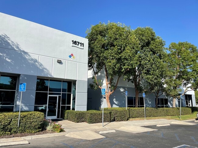
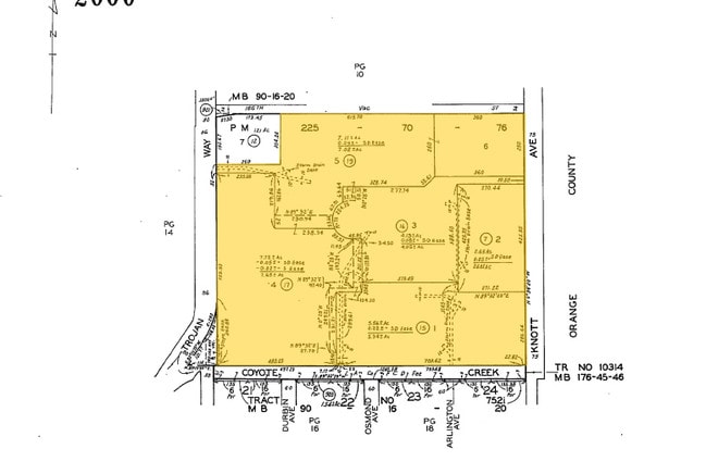
16701 Knott Ave
7001-015-016
P M 225-70-76 FOR DESC SEE ASSESSORS MAPS POR OF LOTS 3 AND 4
Warehouse
Los Angeles
LMM2-M1*
California
B and X Area of moderate flood hazard, usually the area between the limits of the 100-year and 500-year floods.
3,4
2025
4.12 AC
2025
Santa Fe Springs/La Mirada
503902
Los Angeles
59,912 SF
Los Angeles-Long Beach-Glendale, CA
NEARBY LISTINGS FOR SALE OR LEASE
DEMOGRAPHICS near 16701 Knott Ave
1 mile
3 mile
5 mile
2025 Total Population
12,735
173,308
621,374
2030 Population
12,682
171,801
616,744
Pop Growth 2025-2030
(0.42%)
(0.87%)
(0.75%)
Average Age
38
41
40
2025 Total Households
3,793
52,886
187,651
HH Growth 2025-2030
(0.63%)
(1.12%)
(0.92%)
Median Household Inc
$93,126
$109,068
$102,523
Avg Household Size
3.30
3.20
3.20
2025 Avg HH Vehicles
2.00
2.00
2.00
Median Home Value
$777,777
$807,066
$778,604
Median Year Built
1971
1969
1966
Nearby Places
Map Layers
Map Styles
 Street
 Aerial
Layers
 Traffic
 Biking
Places
Listings with unknown addresses are not visible on the map
- Restaurants
- Banks
- Shops
- Fitness
- Groceries
PUBLIC TRANSPORTATION
COMMUTER RAIL
Buena Park (91 Line - Southern California Regional Rail Authority (Metrolink), Orange County Line - Southern California Regional Rail Authority (Metrolink))
Drive
Walk
Distance
Buena Park (91 Line - Southern California Regional Rail Authority (Metrolink), Orange County Line - Southern California Regional Rail Authority (Metrolink))
5 min
2.1 mi
Norwalk/Santa Fe Springs (91 Line - Southern California Regional Rail Authority (Metrolink), Orange County Line - Southern California Regional Rail Authority (Metrolink))
Drive
Walk
Distance
Norwalk/Santa Fe Springs (91 Line - Southern California Regional Rail Authority (Metrolink), Orange County Line - Southern California Regional Rail Authority (Metrolink))
10 min
5.9 mi
AIRPORT
Long Beach (Daugherty Field)
Drive
Walk
Distance
Long Beach (Daugherty Field)
24 min
14.5 mi
John Wayne/Orange County
Drive
Walk
Distance
John Wayne/Orange County
26 min
20.2 mi
Los Angeles International
Drive
Walk
Distance
Los Angeles International
36 min
26.6 mi
Freight Ports
Port of Long Beach
Drive
Walk
Distance
Port of Long Beach
30 min
20.2 mi
Nearby Properties
Address
Land Use
TOTAL SIZE
Lot Size
Zoning
Address
Land Use
TOTAL SIZE
Lot Size
Zoning
57.25 AC
Address
Land Use
TOTAL SIZE
Lot Size
Zoning
150,561 SF
65.24 AC
LMPUD
Address
Land Use
TOTAL SIZE
Lot Size
Zoning
476,442 SF
22.77 AC
Address
Land Use
TOTAL SIZE
Lot Size
Zoning
437,823 SF
19.27 AC
LMM2*
Address
Land Use
TOTAL SIZE
Lot Size
Zoning
564,705 SF
14.35 AC
LCA25*
Address
Land Use
TOTAL SIZE
Lot Size
Zoning
Address
Land Use
TOTAL SIZE
Lot Size
Zoning
12.50 AC
Address
Land Use
TOTAL SIZE
Lot Size
Zoning
281,238 SF
14.83 AC
Address
Land Use
TOTAL SIZE
Lot Size
Zoning
225,016 SF
9.95 AC
LMM2*
Address
Land Use
TOTAL SIZE
Lot Size
Zoning
13.75 AC
Address
Land Use
TOTAL SIZE
Lot Size
Zoning
369,940 SF
8.70 AC
CEM
Address
Land Use
TOTAL SIZE
Lot Size
Zoning
5.90 AC
Address
Land Use
TOTAL SIZE
Lot Size
Zoning
26.92 AC
Address
Land Use
TOTAL SIZE
Lot Size
Zoning
224,131 SF
9.03 AC
CEM
Address
Land Use
TOTAL SIZE
Lot Size
Zoning
345,200 SF
8.51 AC
LMM2
Address
Land Use
TOTAL SIZE
Lot Size
Zoning
140,973 SF
10.03 AC
Address
Land Use
TOTAL SIZE
Lot Size
Zoning
128,481 SF
19.42 AC
LMR1*
Address
Land Use
TOTAL SIZE
Lot Size
Zoning
277,756 SF
10.47 AC
LMM2*
Address
Land Use
TOTAL SIZE
Lot Size
Zoning
46.74 AC
Address
Land Use
TOTAL SIZE
Lot Size
Zoning
266,337 SF
2.40 AC
CE-ADP-16
Address
Land Use
TOTAL SIZE
Lot Size
Zoning
272,080 SF
13.34 AC
C
Address
Land Use
TOTAL SIZE
Lot Size
Zoning
163,350 SF
7.58 AC
CEM
Address
Land Use
TOTAL SIZE
Lot Size
Zoning
249,572 SF
11.76 AC
LMM2*
Address
Land Use
TOTAL SIZE
Lot Size
Zoning
154,616 SF
7.53 AC
CEM
Address
Land Use
TOTAL SIZE
Lot Size
Zoning
237,944 SF
12.09 AC
LMM2*
Address
Land Use
TOTAL SIZE
Lot Size
Zoning
444,784 SF
18.92 AC
SSM2*
Address
Land Use
TOTAL SIZE
Lot Size
Zoning
19.26 AC
Address
Land Use
TOTAL SIZE
Lot Size
Zoning
140,212 SF
6.65 AC
LMM2*
Address
Land Use
TOTAL SIZE
Lot Size
Zoning
21.64 AC
Address
Land Use
TOTAL SIZE
Lot Size
Zoning
1,102,724 SF
25.93 AC
LMM2*
The World's #1 Commercial Real Estate Marketplace
Connect with us
© 2026 CoStar Group
The information above has been obtained from sources believed reliable. While we do not doubt its accuracy we have not verified it and make no guarantee, warranty or representation about it. It is your responsibility to independently confirm its accuracy and completeness. Any projections, opinions, assumptions, or estimates used are for example only and do not represent the current or future performance of the property. The value of this transaction to you depends on tax and other factors which should be evaluated by your tax, financial, and legal advisors. You and your advisors should conduct a careful, independent investigation of the property to determine to your satisfaction the suitability of the property for your needs.