Property Record
1736 S Buckley Rd, Aurora, CO 80017
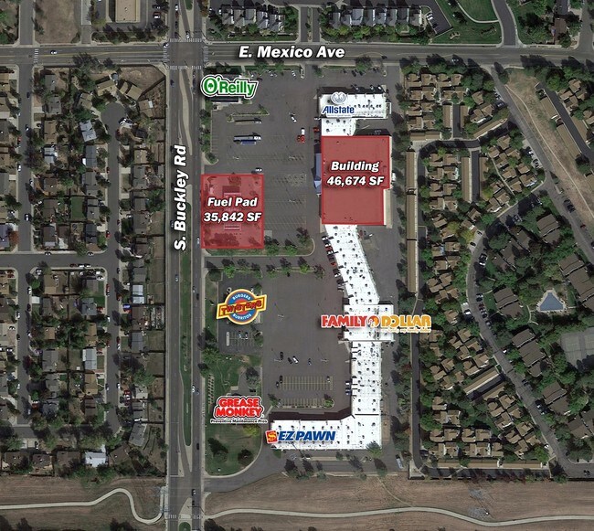

Property Detail
1736 S Buckley Rd
Denver-Aurora-Centennial, CO
TOWNSHIP 4S MAPPLATB 538 MAPPLATP 33 SUBDIVISIONCD 002535 SUBDIVISIONNAME AURORA HIGHLANDS SHOPPING CENTER SUBDIVISION FLG NO 2 BLOCK 001 LOT 002 LOT 2 BLK 1 AURORA HIGHLANDS SHOPPING CENTER SUB FLG NO 2
1975-21-3-35-002
ARAPAHOE
Restaurantbuilding
Colorado
B and X Area of moderate flood hazard, usually the area between the limits of the 100-year and 500-year floods.
2
2025
0.87 AC
2026
Aurora
082800
Denver
4,297 SF
NEARBY LISTINGS FOR SALE OR LEASE
DEMOGRAPHICS near 1736 S Buckley Rd
1 mile
3 mile
5 mile
2025 Total Population
22,366
152,225
354,351
2030 Population
22,575
154,600
360,862
Pop Growth 2025-2030
+ 0.93%
+ 1.56%
+ 1.84%
Average Age
38
39
38
2025 Total Households
8,055
58,055
132,741
HH Growth 2025-2030
+ 1.01%
+ 1.71%
+ 1.93%
Median Household Inc
$87,591
$82,463
$84,124
Avg Household Size
2.70
2.50
2.60
2025 Avg HH Vehicles
2.00
2.00
2.00
Median Home Value
$434,742
$438,364
$463,146
Median Year Built
1981
1983
1984
Nearby Places
Map Layers
Map Styles
 Street
 Aerial
Layers
 Traffic
 Biking
Places
Listings with unknown addresses are not visible on the map
- Restaurants
- Banks
- Shops
- Fitness
- Groceries
PUBLIC TRANSPORTATION
COMMUTER RAIL
40Th Ave & Airport Blvd - Gateway Park Station Track 2 (Union Station to Denver Airport Station - Regional Transportation District)
Drive
Walk
Distance
40Th Ave & Airport Blvd - Gateway Park Station Track 2 (Union Station to Denver Airport Station - Regional Transportation District)
14 min
6.9 mi
Peoria Station Track 1 (Union Station to Denver Airport Station - Regional Transportation District)
Drive
Walk
Distance
Peoria Station Track 1 (Union Station to Denver Airport Station - Regional Transportation District)
15 min
9.3 mi
AIRPORT
Denver International
Drive
Walk
Distance
Denver International
25 min
17.4 mi
Freight Ports
Tulsa Port Of Catoosa
Drive
Walk
Distance
Tulsa Port Of Catoosa
720 min
700.4 mi
SALE & LEASE HISTORY
LISTING DATE
SALE/LEASE

Jul 27, 2017
For Lease
Aug 01, 2018
For Sale
Nearby Properties
Address
Land Use
TOTAL SIZE
Lot Size
Zoning
Address
Land Use
TOTAL SIZE
Lot Size
Zoning
739,979 SF
Address
Land Use
TOTAL SIZE
Lot Size
Zoning
496,493 SF
33.45 AC
Address
Land Use
TOTAL SIZE
Lot Size
Zoning
201,600 SF
44.67 AC
R1
Address
Land Use
TOTAL SIZE
Lot Size
Zoning
476,186 SF
42.62 AC
Address
Land Use
TOTAL SIZE
Lot Size
Zoning
277,940 SF
31.61 AC
Address
Land Use
TOTAL SIZE
Lot Size
Zoning
47,616 SF
140.42 AC
PUD
Address
Land Use
TOTAL SIZE
Lot Size
Zoning
557,843 SF
21.35 AC
PUD
Address
Land Use
TOTAL SIZE
Lot Size
Zoning
315,058 SF
36.85 AC
RPCZD
Address
Land Use
TOTAL SIZE
Lot Size
Zoning
277,985 SF
19.07 AC
Address
Land Use
TOTAL SIZE
Lot Size
Zoning
368,462 SF
11.68 AC
RZMF
Address
Land Use
TOTAL SIZE
Lot Size
Zoning
364,024 SF
23.23 AC
PUD
Address
Land Use
TOTAL SIZE
Lot Size
Zoning
521,364 SF
14.88 AC
PUD
Address
Land Use
TOTAL SIZE
Lot Size
Zoning
77,648 SF
6.21 AC
RM1
Address
Land Use
TOTAL SIZE
Lot Size
Zoning
142,378 SF
14.64 AC
Address
Land Use
TOTAL SIZE
Lot Size
Zoning
462,048 SF
5.34 AC
RB3
Address
Land Use
TOTAL SIZE
Lot Size
Zoning
122,790 SF
14.52 AC
Address
Land Use
TOTAL SIZE
Lot Size
Zoning
328,315 SF
8.15 AC
Address
Land Use
TOTAL SIZE
Lot Size
Zoning
186,088 SF
10.15 AC
RZIND
Address
Land Use
TOTAL SIZE
Lot Size
Zoning
105,809 SF
48.79 AC
Address
Land Use
TOTAL SIZE
Lot Size
Zoning
562,766 SF
7.77 AC
Address
Land Use
TOTAL SIZE
Lot Size
Zoning
215,175 SF
28.07 AC
Address
Land Use
TOTAL SIZE
Lot Size
Zoning
127,530 SF
20.76 AC
Address
Land Use
TOTAL SIZE
Lot Size
Zoning
345,688 SF
15.15 AC
PUD
Address
Land Use
TOTAL SIZE
Lot Size
Zoning
398,436 SF
28.13 AC
Address
Land Use
TOTAL SIZE
Lot Size
Zoning
145,510 SF
9.61 AC
Address
Land Use
TOTAL SIZE
Lot Size
Zoning
135,050 SF
19.38 AC
Address
Land Use
TOTAL SIZE
Lot Size
Zoning
265,326 SF
12.31 AC
RAOD
Address
Land Use
TOTAL SIZE
Lot Size
Zoning
105,244 SF
12.64 AC
RPCZD
Address
Land Use
TOTAL SIZE
Lot Size
Zoning
155,418 SF
13.12 AC
The World's #1 Commercial Real Estate Marketplace
Connect with us
© 2026 CoStar Group
The information above has been obtained from sources believed reliable. While we do not doubt its accuracy we have not verified it and make no guarantee, warranty or representation about it. It is your responsibility to independently confirm its accuracy and completeness. Any projections, opinions, assumptions, or estimates used are for example only and do not represent the current or future performance of the property. The value of this transaction to you depends on tax and other factors which should be evaluated by your tax, financial, and legal advisors. You and your advisors should conduct a careful, independent investigation of the property to determine to your satisfaction the suitability of the property for your needs.