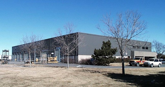
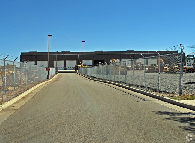
Property Record
18021 E 22Nd Ave, Aurora, CO 80011

Save to a Folder
{{folder.Name}}
{{folder.ListingIds.length}} Properties
{{folder.ListingIds.length}} Property
Create a New Folder
Property Detail
18021 E 22Nd Ave
Denver-Aurora-Centennial, CO
SUB:TOWER CENTER FOR INDUSTRY FILING NO 3 BLK:1 DESC: LOT 1 EXC PT IN HIGHLINE CANAL
1821-33-0-06-007
Adams
Warehouse
Colorado
B and X Area of moderate flood hazard, usually the area between the limits of the 100-year and 500-year floods.
1
2024
54.34 AC
2025
SW DIA/Pena Blvd
008309
Denver
300,759 SF
NEARBY LISTINGS FOR SALE OR LEASE
DEMOGRAPHICS near 18021 E 22Nd Ave
1 mile
3 mile
5 mile
2025 Total Population
5,397
79,692
249,175
2030 Population
5,517
82,053
257,578
Pop Growth 2025-2030
+ 2.22%
+ 2.96%
+ 3.37%
Average Age
35
35
36
2025 Total Households
1,625
25,022
82,085
HH Growth 2025-2030
+ 2.40%
+ 3.03%
+ 3.50%
Median Household Inc
$72,288
$82,022
$83,092
Avg Household Size
3.30
3.00
2.90
2025 Avg HH Vehicles
2.00
2.00
2.00
Median Home Value
$354,109
$441,375
$441,753
Median Year Built
1986
1997
1988
Nearby Places
Map Layers
Map Styles
 Street
 Aerial
Layers
 Traffic
 Biking
Places
Listings with unknown addresses are not visible on the map
- Restaurants
- Banks
- Shops
- Fitness
- Groceries
PUBLIC TRANSPORTATION
COMMUTER RAIL
Drive
Walk
Distance
7 min
2.4 mi
Drive
Walk
Distance
11 min
5.8 mi
AIRPORT
Denver International
Drive
Walk
Distance
Denver International
19 min
13.8 mi
Nearby Properties
Address
Land Use
TOTAL SIZE
Lot Size
Zoning
Address
Land Use
TOTAL SIZE
Lot Size
Zoning
934,913 SF
116.11 AC
Address
Land Use
TOTAL SIZE
Lot Size
Zoning
1,078,683 SF
68.01 AC
Address
Land Use
TOTAL SIZE
Lot Size
Zoning
244,271 SF
15.30 AC
Address
Land Use
TOTAL SIZE
Lot Size
Zoning
739,979 SF
Address
Land Use
TOTAL SIZE
Lot Size
Zoning
1,016,116 SF
69.40 AC
Address
Land Use
TOTAL SIZE
Lot Size
Zoning
868,780 SF
105.02 AC
Address
Land Use
TOTAL SIZE
Lot Size
Zoning
876,549 SF
46.65 AC
Address
Land Use
TOTAL SIZE
Lot Size
Zoning
200,105 SF
34.54 AC
C-MU-20
Address
Land Use
TOTAL SIZE
Lot Size
Zoning
704,978 SF
36.17 AC
Address
Land Use
TOTAL SIZE
Lot Size
Zoning
102,444 SF
3.76 AC
GTWY
Address
Land Use
TOTAL SIZE
Lot Size
Zoning
691,200 SF
38.09 AC
Address
Land Use
TOTAL SIZE
Lot Size
Zoning
140.42 AC
Address
Land Use
TOTAL SIZE
Lot Size
Zoning
111,077 SF
3.06 AC
Address
Land Use
TOTAL SIZE
Lot Size
Zoning
550,031 SF
37.73 AC
Address
Land Use
TOTAL SIZE
Lot Size
Zoning
185,812 SF
20.93 AC
C-MU-20
Address
Land Use
TOTAL SIZE
Lot Size
Zoning
555,867 SF
33.81 AC
Address
Land Use
TOTAL SIZE
Lot Size
Zoning
582,400 SF
43.29 AC
Address
Land Use
TOTAL SIZE
Lot Size
Zoning
545,010 SF
35.35 AC
Address
Land Use
TOTAL SIZE
Lot Size
Zoning
512,720 SF
42.32 AC
Address
Land Use
TOTAL SIZE
Lot Size
Zoning
522,120 SF
27.70 AC
Address
Land Use
TOTAL SIZE
Lot Size
Zoning
500,358 SF
23.59 AC
Address
Land Use
TOTAL SIZE
Lot Size
Zoning
455,520 SF
53.29 AC
Address
Land Use
TOTAL SIZE
Lot Size
Zoning
548,510 SF
27.26 AC
Address
Land Use
TOTAL SIZE
Lot Size
Zoning
433,280 SF
23.46 AC
Address
Land Use
TOTAL SIZE
Lot Size
Zoning
593,928 SF
32.25 AC
Address
Land Use
TOTAL SIZE
Lot Size
Zoning
452,400 SF
20.99 AC
Address
Land Use
TOTAL SIZE
Lot Size
Zoning
432,600 SF
30.98 AC
Address
Land Use
TOTAL SIZE
Lot Size
Zoning
461,580 SF
23.56 AC
Address
Land Use
TOTAL SIZE
Lot Size
Zoning
419,630 SF
24.34 AC
Address
Land Use
TOTAL SIZE
Lot Size
Zoning
58,997 SF
2.05 AC
S-CC-5X
The World's #1 Commercial Real Estate Marketplace
Connect with us
© 2026 CoStar Group
The information above has been obtained from sources believed reliable. While we do not doubt its accuracy we have not verified it and make no guarantee, warranty or representation about it. It is your responsibility to independently confirm its accuracy and completeness. Any projections, opinions, assumptions, or estimates used are for example only and do not represent the current or future performance of the property. The value of this transaction to you depends on tax and other factors which should be evaluated by your tax, financial, and legal advisors. You and your advisors should conduct a careful, independent investigation of the property to determine to your satisfaction the suitability of the property for your needs.