Property Record
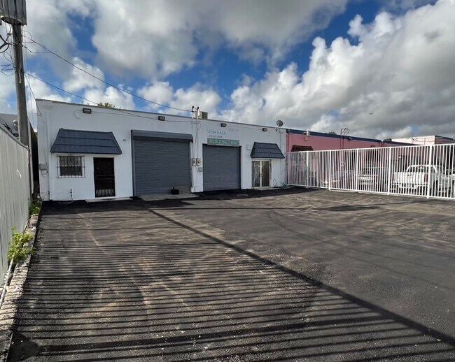
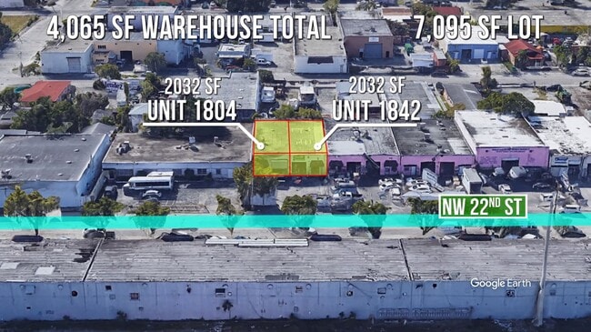
1840 Nw 22Nd St, Miami, FL 33142


Property Detail
1840 Nw 22Nd St
01-3127-039-0670
27 53 41 PINEHURST PB 3-49 LOT 9 BLK 5 LOT SIZE 7095 SQ FT OR 20041-4745 1001 4 COC 25558-4644 04 2007 4
Foodprocessing
Miami-Dade
7700
Florida
AE The base floodplain where base flood elevations are provided. AE Zones are now used on new format FIRMs instead of A1-A30 Zones.
9
2024
0.16 AC
2025
South Central Miami
002402
South Florida
4,050 SF
Miami-Miami Beach-Kendall, FL
NEARBY LISTINGS FOR SALE OR LEASE
DEMOGRAPHICS near 1840 Nw 22Nd St
1 mile
3 mile
5 mile
2025 Total Population
42,237
344,970
649,647
2030 Population
45,149
373,513
700,232
Pop Growth 2025-2030
+ 6.89%
+ 8.27%
+ 7.79%
Average Age
42
41
42
2025 Total Households
15,432
140,806
264,762
HH Growth 2025-2030
+ 7.00%
+ 8.60%
+ 8.05%
Median Household Inc
$39,713
$57,789
$65,774
Avg Household Size
2.50
2.30
2.30
2025 Avg HH Vehicles
1.00
1.00
1.00
Median Home Value
$387,442
$484,188
$580,417
Median Year Built
1970
1977
1975
Nearby Places
Map Layers
Map Styles
 Street
 Aerial
Layers
 Traffic
 Biking
Places
Listings with unknown addresses are not visible on the map
- Restaurants
- Banks
- Shops
- Fitness
- Groceries
PUBLIC TRANSPORTATION
COMMUTER RAIL
Santa Clara (Metrorail Green Line - Miami-Dade Transit (Metrorail/Metromover))
Drive
Walk
Distance
Santa Clara (Metrorail Green Line - Miami-Dade Transit (Metrorail/Metromover))
2 min
16 min
0.9 mi
Uhealth Jackson Station Rail Northbound (REGULAR METRORAIL SERVICE - Miami-Dade Transit (Metrorail/Metromover))
Drive
Walk
Distance
Uhealth Jackson Station Rail Northbound (REGULAR METRORAIL SERVICE - Miami-Dade Transit (Metrorail/Metromover))
3 min
1.3 mi
AIRPORT
Miami International
Drive
Walk
Distance
Miami International
19 min
7.7 mi
Fort Lauderdale/Hollywood International
Drive
Walk
Distance
Fort Lauderdale/Hollywood International
34 min
23.1 mi
Freight Ports
Port of Miami
Drive
Walk
Distance
Port of Miami
12 min
5.5 mi
SALE & LEASE HISTORY
LISTING DATE
SALE/LEASE

Oct 09, 2022
For Sale
Mar 25, 2021
For Sale
Jan 25, 2023
For Sale
Feb 07, 2023
For Sale
Nearby Properties
Address
Land Use
TOTAL SIZE
Lot Size
Zoning
Address
Land Use
TOTAL SIZE
Lot Size
Zoning
955,966 SF
38.91 AC
9600
Address
Land Use
TOTAL SIZE
Lot Size
Zoning
2,039,308 SF
2.46 AC
6401
Address
Land Use
TOTAL SIZE
Lot Size
Zoning
928,000 SF
14.30 AC
8000
Address
Land Use
TOTAL SIZE
Lot Size
Zoning
16.13 AC
6100
Address
Land Use
TOTAL SIZE
Lot Size
Zoning
2,789,683 SF
33.23 AC
7300
Address
Land Use
TOTAL SIZE
Lot Size
Zoning
1,346,294 SF
1.89 AC
6408
Address
Land Use
TOTAL SIZE
Lot Size
Zoning
2,403,353 SF
7.37 AC
6100
Address
Land Use
TOTAL SIZE
Lot Size
Zoning
1,938,271 SF
6.62 AC
6402
Address
Land Use
TOTAL SIZE
Lot Size
Zoning
1,075,124 SF
1.61 AC
6405
Address
Land Use
TOTAL SIZE
Lot Size
Zoning
1,544,491 SF
0.97 AC
6401
Address
Land Use
TOTAL SIZE
Lot Size
Zoning
1,657,362 SF
1.15 AC
6401
Address
Land Use
TOTAL SIZE
Lot Size
Zoning
244,533 SF
3.53 AC
6600
Address
Land Use
TOTAL SIZE
Lot Size
Zoning
303,989 SF
1.47 AC
6600
Address
Land Use
TOTAL SIZE
Lot Size
Zoning
416,675 SF
6.48 AC
6401
Address
Land Use
TOTAL SIZE
Lot Size
Zoning
256,089 SF
20.35 AC
7600
Address
Land Use
TOTAL SIZE
Lot Size
Zoning
1,004,006 SF
0.92 AC
6401
Address
Land Use
TOTAL SIZE
Lot Size
Zoning
585,775 SF
1.86 AC
6101
Address
Land Use
TOTAL SIZE
Lot Size
Zoning
868,860 SF
2.14 AC
6402
Address
Land Use
TOTAL SIZE
Lot Size
Zoning
491,308 SF
0.14 AC
6401
Address
Land Use
TOTAL SIZE
Lot Size
Zoning
872,245 SF
0.56 AC
6401
Address
Land Use
TOTAL SIZE
Lot Size
Zoning
727,757 SF
0.64 AC
6408
Address
Land Use
TOTAL SIZE
Lot Size
Zoning
615,785 SF
3.81 AC
4604
Address
Land Use
TOTAL SIZE
Lot Size
Zoning
2 AC
8000
Address
Land Use
TOTAL SIZE
Lot Size
Zoning
1,262,330 SF
1.39 AC
6402
Address
Land Use
TOTAL SIZE
Lot Size
Zoning
616,963 SF
0.75 AC
6401
Address
Land Use
TOTAL SIZE
Lot Size
Zoning
845,870 SF
1.30 AC
6412
Address
Land Use
TOTAL SIZE
Lot Size
Zoning
790,139 SF
1.80 AC
6110
Address
Land Use
TOTAL SIZE
Lot Size
Zoning
604,146 SF
5.66 AC
6600
Address
Land Use
TOTAL SIZE
Lot Size
Zoning
656,110 SF
1.75 AC
6401
Address
Land Use
TOTAL SIZE
Lot Size
Zoning
570,694 SF
1.37 AC
4604
The World's #1 Commercial Real Estate Marketplace
Connect with us
© 2026 CoStar Group
The information above has been obtained from sources believed reliable. While we do not doubt its accuracy we have not verified it and make no guarantee, warranty or representation about it. It is your responsibility to independently confirm its accuracy and completeness. Any projections, opinions, assumptions, or estimates used are for example only and do not represent the current or future performance of the property. The value of this transaction to you depends on tax and other factors which should be evaluated by your tax, financial, and legal advisors. You and your advisors should conduct a careful, independent investigation of the property to determine to your satisfaction the suitability of the property for your needs.