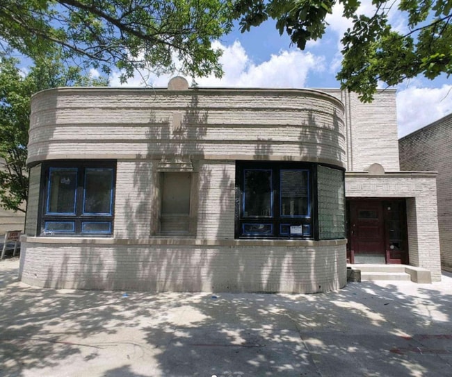
Property Record
1912 W 103Rd St, Chicago, IL 60643

Current Lease Availabilities
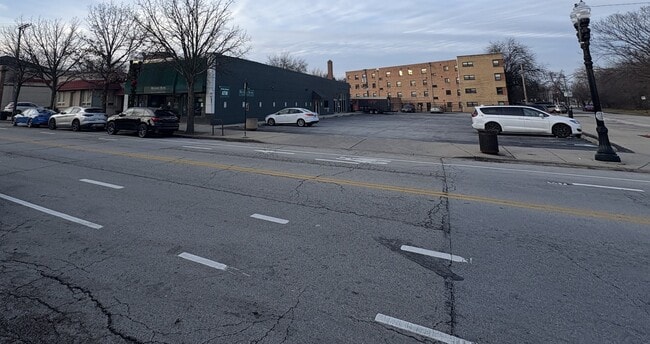
NEARBY LISTINGS FOR SALE OR LEASE
Property Detail
1912 W 103Rd St
Chicago-Naperville-Elgin, IL-IN-WI
Barnards
25-07-412-055-0000
Cook
Commercialbuilding
Illinois
X
14,15
17031C0635J
0.19 AC
2023
South Chicago
2025
Chicago
720200
DEMOGRAPHICS near 1912 W 103Rd St
1 Mile
3 Mile
5 Mile
2024 Total Population
20,209
201,699
498,343
2029 Population
19,494
195,385
482,109
Pop Growth 2024-2029
(3.54%)
(3.13%)
(3.26%)
Average Age
42
41
40
2024 Total Households
7,808
75,964
187,617
HH Growth 2024-2029
(3.83%)
(3.51%)
(3.62%)
Median Household Inc
$93,327
$63,469
$53,424
Avg Household Size
2.50
2.50
2.60
2024 Avg HH Vehicles
2.00
1.00
1.00
Median Home Value
$320,248
$201,576
$191,838
Median Year Built
1947
1952
1953
Nearby Places
Map Layers
Map Styles
 Street
 Aerial
- Restaurants
- Banks
- Shops
- Fitness
- Groceries
PUBLIC TRANSPORTATION
TRANSIT/SUBWAY
103rd Street Station (Rock Island District Line - Northeast Illinois Regional Commuter Railroad (Metra))
DRIVE
WALK
Distance
103rd Street Station (Rock Island District Line - Northeast Illinois Regional Commuter Railroad (Metra))
1 min
2 min
0.1 mi
99th Street Station (Rock Island District Line - Northeast Illinois Regional Commuter Railroad (Metra))
DRIVE
WALK
Distance
99th Street Station (Rock Island District Line - Northeast Illinois Regional Commuter Railroad (Metra))
2 min
11 min
0.6 mi
107th Street Station (Rock Island Line) (Rock Island District Line - Northeast Illinois Regional Commuter Railroad (Metra))
DRIVE
WALK
Distance
107th Street Station (Rock Island Line) (Rock Island District Line - Northeast Illinois Regional Commuter Railroad (Metra))
2 min
12 min
0.6 mi
Washington Heights Station (Rock Island District Line - Northeast Illinois Regional Commuter Railroad (Metra))
DRIVE
WALK
Distance
Washington Heights Station (Rock Island District Line - Northeast Illinois Regional Commuter Railroad (Metra))
2 min
18 min
0.8 mi
111th Street Station (Rock Island District Line - Northeast Illinois Regional Commuter Railroad (Metra))
DRIVE
WALK
Distance
111th Street Station (Rock Island District Line - Northeast Illinois Regional Commuter Railroad (Metra))
3 min
20 min
1.1 mi
COMMUTER RAIL
103rd Street Station (Rock Island District Line - Northeast Illinois Regional Commuter Railroad (Metra))
DRIVE
WALK
Distance
103rd Street Station (Rock Island District Line - Northeast Illinois Regional Commuter Railroad (Metra))
1 min
2 min
0.1 mi
99th Street Station (Rock Island District Line - Northeast Illinois Regional Commuter Railroad (Metra))
DRIVE
WALK
Distance
99th Street Station (Rock Island District Line - Northeast Illinois Regional Commuter Railroad (Metra))
2 min
10 min
0.5 mi
AIRPORT
Chicago Midway International
DRIVE
WALK
Distance
Chicago Midway International
18 min
10.3 mi
Chicago O'Hare International
DRIVE
WALK
Distance
Chicago O'Hare International
48 min
31.7 mi
Nearby Properties
Address
Land Use
TOTAL SIZE
Lot Size
Zoning
Address
Land Use
TOTAL SIZE
Lot Size
Zoning
8 AC
PD 1168
Address
Land Use
TOTAL SIZE
Lot Size
Zoning
0.51 AC
PD 1168
Address
Land Use
TOTAL SIZE
Lot Size
Zoning
1.08 AC
PD 1168
Address
Land Use
TOTAL SIZE
Lot Size
Zoning
11 AC
PD 1168
Address
Land Use
TOTAL SIZE
Lot Size
Zoning
307,335 SF
24.17 AC
PD 770
Address
Land Use
TOTAL SIZE
Lot Size
Zoning
67,348 SF
6.33 AC
PD 131
Address
Land Use
TOTAL SIZE
Lot Size
Zoning
87,830 SF
0.76 AC
B1-1
Address
Land Use
TOTAL SIZE
Lot Size
Zoning
63,930 SF
3.49 AC
PD 181
Address
Land Use
TOTAL SIZE
Lot Size
Zoning
157,787 SF
12.23 AC
Address
Land Use
TOTAL SIZE
Lot Size
Zoning
Address
Land Use
TOTAL SIZE
Lot Size
Zoning
223,310 SF
15.67 AC
Address
Land Use
TOTAL SIZE
Lot Size
Zoning
129,837 SF
10.44 AC
PD 770
Address
Land Use
TOTAL SIZE
Lot Size
Zoning
224,089 SF
Address
Land Use
TOTAL SIZE
Lot Size
Zoning
82,000 SF
Address
Land Use
TOTAL SIZE
Lot Size
Zoning
99,900 SF
12.45 AC
PD 1172
Address
Land Use
TOTAL SIZE
Lot Size
Zoning
63,700 SF
0.74 AC
C1-1
Address
Land Use
TOTAL SIZE
Lot Size
Zoning
98,506 SF
7.66 AC
Address
Land Use
TOTAL SIZE
Lot Size
Zoning
1 AC
RS-3
Address
Land Use
TOTAL SIZE
Lot Size
Zoning
105,150 SF
4 AC
Address
Land Use
TOTAL SIZE
Lot Size
Zoning
285,672 SF
13.14 AC
Address
Land Use
TOTAL SIZE
Lot Size
Zoning
101,294 SF
8.10 AC
B3-1
Address
Land Use
TOTAL SIZE
Lot Size
Zoning
111,198 SF
10.60 AC
PD 566
Address
Land Use
TOTAL SIZE
Lot Size
Zoning
0.54 AC
RS-3
Address
Land Use
TOTAL SIZE
Lot Size
Zoning
451,400 SF
26.59 AC
M3-3
Address
Land Use
TOTAL SIZE
Lot Size
Zoning
151,175 SF
11.53 AC
PD 966
Address
Land Use
TOTAL SIZE
Lot Size
Zoning
1.71 AC
PD 1168
Address
Land Use
TOTAL SIZE
Lot Size
Zoning
63,700 SF
0.42 AC
C1-1
Address
Land Use
TOTAL SIZE
Lot Size
Zoning
0.25 AC
PD 548
Address
Land Use
TOTAL SIZE
Lot Size
Zoning
109,213 SF
7.59 AC
Address
Land Use
TOTAL SIZE
Lot Size
Zoning
2.26 AC
The World's #1 Commercial Real Estate Marketplace
Connect with us
© 2026 CoStar Group
The information above has been obtained from sources believed reliable. While we do not doubt its accuracy we have not verified it and make no guarantee, warranty or representation about it. It is your responsibility to independently confirm its accuracy and completeness. Any projections, opinions, assumptions, or estimates used are for example only and do not represent the current or future performance of the property. The value of this transaction to you depends on tax and other factors which should be evaluated by your tax, financial, and legal advisors. You and your advisors should conduct a careful, independent investigation of the property to determine to your satisfaction the suitability of the property for your needs.