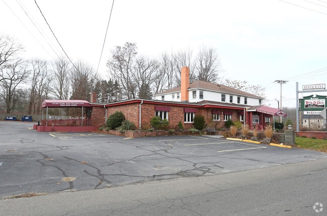
Property Record
192 E Main St, Clinton, CT 06413


Save to a Folder
{{folder.Name}}
{{folder.ListingIds.length}} Properties
{{folder.ListingIds.length}} Property
Create a New Folder
Property Detail
192 E Main St
CLIN-000068-000065-000056
Lower Ct River Vly
Commercialacreage
Connecticut
B-4
56
B and X Area of moderate flood hazard, usually the area between the limits of the 100-year and 500-year floods.
0.77 AC
2025
SW Midlsx/Old Saybrk/Rt 9
2025
Hartford
610200
Hartford-West Hartford-East Hartford, CT
5,344 SF
NEARBY LISTINGS FOR SALE OR LEASE
DEMOGRAPHICS near 192 E Main St
1 mile
3 mile
5 mile
2025 Total Population
3,792
14,596
29,355
2030 Population
3,906
15,037
30,274
Pop Growth 2025-2030
+ 3.01%
+ 3.02%
+ 3.13%
Average Age
48
48
47
2025 Total Households
1,764
6,556
12,705
HH Growth 2025-2030
+ 3.23%
+ 3.36%
+ 3.42%
Median Household Inc
$111,855
$102,374
$110,259
Avg Household Size
2.00
2.20
2.20
2025 Avg HH Vehicles
2.00
2.00
2.00
Median Home Value
$450,000
$415,759
$468,141
Median Year Built
1964
1966
1970
Nearby Places
Map Layers
Map Styles
 Street
 Aerial
Layers
 Traffic
 Biking
Places
Listings with unknown addresses are not visible on the map
- Restaurants
- Banks
- Shops
- Fitness
- Groceries
PUBLIC TRANSPORTATION
COMMUTER RAIL
Clinton (Commuter Rail - Shore Line East)
Drive
Walk
Distance
Clinton (Commuter Rail - Shore Line East)
3 min
1.2 mi
Westbrook (Commuter Rail - Shore Line East)
Drive
Walk
Distance
Westbrook (Commuter Rail - Shore Line East)
7 min
3.8 mi
AIRPORT
Tweed/New Haven
Drive
Walk
Distance
Tweed/New Haven
31 min
21.6 mi
Freight Ports
Port of New Haven
Drive
Walk
Distance
Port of New Haven
31 min
22.2 mi
SALE & LEASE HISTORY
LISTING DATE
SALE/LEASE

Jul 30, 2020
For Sale
Nearby Properties
Address
Land Use
TOTAL SIZE
Lot Size
Zoning
Address
Land Use
TOTAL SIZE
Lot Size
Zoning
47.11 AC
Address
Land Use
TOTAL SIZE
Lot Size
Zoning
138,909 SF
41.60 AC
R-20
Address
Land Use
TOTAL SIZE
Lot Size
Zoning
322.64 AC
RR/MDR
Address
Land Use
TOTAL SIZE
Lot Size
Zoning
87,717 SF
12 AC
Address
Land Use
TOTAL SIZE
Lot Size
Zoning
624 SF
43.91 AC
CB
Address
Land Use
TOTAL SIZE
Lot Size
Zoning
98,963 SF
49.97 AC
Address
Land Use
TOTAL SIZE
Lot Size
Zoning
81,335 SF
8.64 AC
B-4
Address
Land Use
TOTAL SIZE
Lot Size
Zoning
96,949 SF
11.52 AC
Address
Land Use
TOTAL SIZE
Lot Size
Zoning
540 SF
8.25 AC
C
Address
Land Use
TOTAL SIZE
Lot Size
Zoning
54,375 SF
7.01 AC
Address
Land Use
TOTAL SIZE
Lot Size
Zoning
15,446 SF
7.56 AC
B-2
Address
Land Use
TOTAL SIZE
Lot Size
Zoning
822 SF
6 AC
R-2
Address
Land Use
TOTAL SIZE
Lot Size
Zoning
46,536 SF
3.62 AC
Address
Land Use
TOTAL SIZE
Lot Size
Zoning
35.50 AC
CB
Address
Land Use
TOTAL SIZE
Lot Size
Zoning
22,984 SF
6.58 AC
MDR
Address
Land Use
TOTAL SIZE
Lot Size
Zoning
56,608 SF
1.27 AC
I-1
Address
Land Use
TOTAL SIZE
Lot Size
Zoning
3,872 SF
49.73 AC
R-80
Address
Land Use
TOTAL SIZE
Lot Size
Zoning
5.56 AC
Address
Land Use
TOTAL SIZE
Lot Size
Zoning
85,800 SF
11.56 AC
LI/RR
Address
Land Use
TOTAL SIZE
Lot Size
Zoning
3,077 SF
2.86 AC
T
Address
Land Use
TOTAL SIZE
Lot Size
Zoning
24,632 SF
4.48 AC
LI
Address
Land Use
TOTAL SIZE
Lot Size
Zoning
9.32 AC
M-1
Address
Land Use
TOTAL SIZE
Lot Size
Zoning
30,922 SF
1.23 AC
C
Address
Land Use
TOTAL SIZE
Lot Size
Zoning
640 SF
3 AC
T
Address
Land Use
TOTAL SIZE
Lot Size
Zoning
25,080 SF
2.77 AC
B-3
Address
Land Use
TOTAL SIZE
Lot Size
Zoning
13,448 SF
2.14 AC
B-4
Address
Land Use
TOTAL SIZE
Lot Size
Zoning
928 SF
2.60 AC
R-2
Address
Land Use
TOTAL SIZE
Lot Size
Zoning
912 SF
6.63 AC
HDR/MD
Address
Land Use
TOTAL SIZE
Lot Size
Zoning
2.86 AC
R-10
Address
Land Use
TOTAL SIZE
Lot Size
Zoning
124.24 AC
R-30
The World's #1 Commercial Real Estate Marketplace
Connect with us
© 2026 CoStar Group
The information above has been obtained from sources believed reliable. While we do not doubt its accuracy we have not verified it and make no guarantee, warranty or representation about it. It is your responsibility to independently confirm its accuracy and completeness. Any projections, opinions, assumptions, or estimates used are for example only and do not represent the current or future performance of the property. The value of this transaction to you depends on tax and other factors which should be evaluated by your tax, financial, and legal advisors. You and your advisors should conduct a careful, independent investigation of the property to determine to your satisfaction the suitability of the property for your needs.