Property Record
200 Maine St, Vallejo, CA 94590
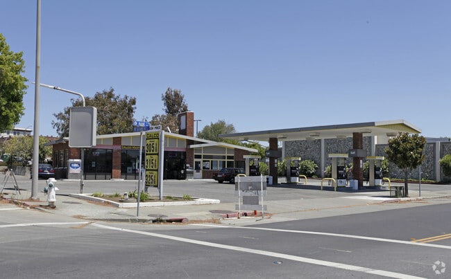


Property Detail
200 Maine St
Vallejo, CA
LOT 403
0055-170-300
Solano
Servicestation
California
B and X Area of moderate flood hazard, usually the area between the limits of the 100-year and 500-year floods.
403
2024
0.49 AC
2025
Vallejo
250900
North Bay/Santa Rosa
1,971 SF
NEARBY LISTINGS FOR SALE OR LEASE
DEMOGRAPHICS near 200 Maine St
1 mile
3 mile
5 mile
2025 Total Population
14,330
84,887
156,869
2030 Population
14,524
85,649
157,630
Pop Growth 2025-2030
+ 1.35%
+ 0.90%
+ 0.49%
Average Age
40
40
41
2025 Total Households
5,984
30,737
54,009
HH Growth 2025-2030
+ 1.39%
+ 0.98%
+ 0.60%
Median Household Inc
$51,618
$77,211
$93,332
Avg Household Size
2.30
2.60
2.80
2025 Avg HH Vehicles
1.00
2.00
2.00
Median Home Value
$630,208
$615,628
$668,808
Median Year Built
1948
1963
1974
Nearby Places
Map Layers
Map Styles
 Street
 Aerial
Layers
 Traffic
 Biking
Places
Listings with unknown addresses are not visible on the map
- Restaurants
- Banks
- Shops
- Fitness
- Groceries
PUBLIC TRANSPORTATION
AIRPORT
Metro Oakland International
Drive
Walk
Distance
Metro Oakland International
47 min
35.5 mi
Freight Ports
Port of Richmond
Drive
Walk
Distance
Port of Richmond
32 min
21.2 mi
Nearby Properties
Address
Land Use
TOTAL SIZE
Lot Size
Zoning
Address
Land Use
TOTAL SIZE
Lot Size
Zoning
432,550 SF
29.70 AC
Address
Land Use
TOTAL SIZE
Lot Size
Zoning
349.61 AC
Address
Land Use
TOTAL SIZE
Lot Size
Zoning
197,656 SF
18.63 AC
Address
Land Use
TOTAL SIZE
Lot Size
Zoning
92,043 SF
8.99 AC
Address
Land Use
TOTAL SIZE
Lot Size
Zoning
123,566 SF
7.17 AC
Address
Land Use
TOTAL SIZE
Lot Size
Zoning
176,119 SF
6.80 AC
CHANGE-MUL
Address
Land Use
TOTAL SIZE
Lot Size
Zoning
4.23 AC
COMM
Address
Land Use
TOTAL SIZE
Lot Size
Zoning
43.81 AC
Address
Land Use
TOTAL SIZE
Lot Size
Zoning
7.86 AC
Address
Land Use
TOTAL SIZE
Lot Size
Zoning
128,544 SF
5.92 AC
Address
Land Use
TOTAL SIZE
Lot Size
Zoning
175,831 SF
8.63 AC
Address
Land Use
TOTAL SIZE
Lot Size
Zoning
151,720 SF
8 AC
HDR
Address
Land Use
TOTAL SIZE
Lot Size
Zoning
240,905 SF
19.12 AC
Address
Land Use
TOTAL SIZE
Lot Size
Zoning
108,316 SF
5.31 AC
MULTI RES
Address
Land Use
TOTAL SIZE
Lot Size
Zoning
73,819 SF
5.64 AC
Address
Land Use
TOTAL SIZE
Lot Size
Zoning
178,265 SF
10.87 AC
Address
Land Use
TOTAL SIZE
Lot Size
Zoning
4.99 AC
Address
Land Use
TOTAL SIZE
Lot Size
Zoning
119,746 SF
0.64 AC
Address
Land Use
TOTAL SIZE
Lot Size
Zoning
83,768 SF
4.08 AC
Address
Land Use
TOTAL SIZE
Lot Size
Zoning
86,116 SF
4.64 AC
Address
Land Use
TOTAL SIZE
Lot Size
Zoning
82,058 SF
6.45 AC
Address
Land Use
TOTAL SIZE
Lot Size
Zoning
150,719 SF
14.16 AC
Address
Land Use
TOTAL SIZE
Lot Size
Zoning
130,460 SF
11.91 AC
Address
Land Use
TOTAL SIZE
Lot Size
Zoning
78,742 SF
0.67 AC
Address
Land Use
TOTAL SIZE
Lot Size
Zoning
113,152 SF
9.71 AC
Address
Land Use
TOTAL SIZE
Lot Size
Zoning
69,011 SF
3.67 AC
PUBLIC-PF
Address
Land Use
TOTAL SIZE
Lot Size
Zoning
60,597 SF
3.21 AC
Address
Land Use
TOTAL SIZE
Lot Size
Zoning
57,267 SF
3.42 AC
Address
Land Use
TOTAL SIZE
Lot Size
Zoning
95,280 SF
3.75 AC
Address
Land Use
TOTAL SIZE
Lot Size
Zoning
65,856 SF
3.49 AC
The World's #1 Commercial Real Estate Marketplace
Connect with us
© 2026 CoStar Group
The information above has been obtained from sources believed reliable. While we do not doubt its accuracy we have not verified it and make no guarantee, warranty or representation about it. It is your responsibility to independently confirm its accuracy and completeness. Any projections, opinions, assumptions, or estimates used are for example only and do not represent the current or future performance of the property. The value of this transaction to you depends on tax and other factors which should be evaluated by your tax, financial, and legal advisors. You and your advisors should conduct a careful, independent investigation of the property to determine to your satisfaction the suitability of the property for your needs.