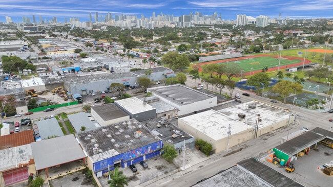
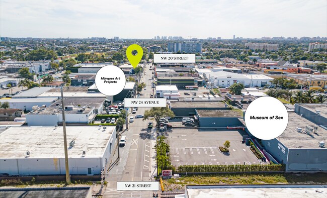
Property Record
2047 Nw 24Th Ave, Miami, FL 33142

Save to a Folder
{{folder.Name}}
{{folder.ListingIds.length}} Properties
{{folder.ListingIds.length}} Property
Create a New Folder
This Property Is For Sale
Property Detail
2047 Nw 24Th Ave
01-3127-046-1100
DR BURKHARTS WINTER GARDENS PB 5-22 LOT 11 BLK 5 LOT SIZE 7350 SQ FT OR 20739-3382 1002 6 (2)
Warehouse
Miami-Dade
7700
Florida
AE The base floodplain where base flood elevations are provided. AE Zones are now used on new format FIRMs instead of A1-A30 Zones.
11
2025
0.17 AC
2025
South Central Miami
002402
South Florida
5,000 SF
Miami-Miami Beach-Kendall, FL
NEARBY LISTINGS FOR SALE OR LEASE
DEMOGRAPHICS near 2047 Nw 24Th Ave
1 mile
3 mile
5 mile
2025 Total Population
37,155
316,190
661,976
2030 Population
39,568
340,373
713,108
Pop Growth 2025-2030
+ 6.49%
+ 7.65%
+ 7.72%
Average Age
42
41
42
2025 Total Households
13,743
123,522
268,351
HH Growth 2025-2030
+ 6.56%
+ 7.95%
+ 7.99%
Median Household Inc
$42,041
$51,279
$65,553
Avg Household Size
2.50
2.40
2.30
2025 Avg HH Vehicles
1.00
1.00
1.00
Median Home Value
$423,102
$469,881
$576,520
Median Year Built
1968
1970
1974
Nearby Places
Map Layers
Map Styles
 Street
 Aerial
Layers
 Traffic
 Biking
Places
Listings with unknown addresses are not visible on the map
- Restaurants
- Banks
- Shops
- Fitness
- Groceries
PUBLIC TRANSPORTATION
COMMUTER RAIL
Santa Clara (Metrorail Green Line - Miami-Dade Transit (Metrorail/Metromover))
Drive
Walk
Distance
Santa Clara (Metrorail Green Line - Miami-Dade Transit (Metrorail/Metromover))
3 min
1.4 mi
Earlington Heights (Metrorail Green Line - Miami-Dade Transit (Metrorail/Metromover))
Drive
Walk
Distance
Earlington Heights (Metrorail Green Line - Miami-Dade Transit (Metrorail/Metromover))
10 min
5.6 mi
AIRPORT
Miami International
Drive
Walk
Distance
Miami International
17 min
6.9 mi
Fort Lauderdale/Hollywood International
Drive
Walk
Distance
Fort Lauderdale/Hollywood International
34 min
23.3 mi
Freight Ports
Port of Miami
Drive
Walk
Distance
Port of Miami
13 min
5.7 mi
Nearby Properties
Address
Land Use
TOTAL SIZE
Lot Size
Zoning
Address
Land Use
TOTAL SIZE
Lot Size
Zoning
955,966 SF
38.91 AC
9600
Address
Land Use
TOTAL SIZE
Lot Size
Zoning
928,000 SF
14.30 AC
8000
Address
Land Use
TOTAL SIZE
Lot Size
Zoning
16.13 AC
6100
Address
Land Use
TOTAL SIZE
Lot Size
Zoning
2,789,683 SF
33.23 AC
7300
Address
Land Use
TOTAL SIZE
Lot Size
Zoning
2,403,353 SF
7.37 AC
6100
Address
Land Use
TOTAL SIZE
Lot Size
Zoning
1,938,271 SF
6.62 AC
6402
Address
Land Use
TOTAL SIZE
Lot Size
Zoning
1,075,124 SF
1.61 AC
6405
Address
Land Use
TOTAL SIZE
Lot Size
Zoning
1,544,491 SF
0.97 AC
6401
Address
Land Use
TOTAL SIZE
Lot Size
Zoning
244,533 SF
3.53 AC
6600
Address
Land Use
TOTAL SIZE
Lot Size
Zoning
303,989 SF
1.47 AC
6600
Address
Land Use
TOTAL SIZE
Lot Size
Zoning
416,675 SF
6.48 AC
6401
Address
Land Use
TOTAL SIZE
Lot Size
Zoning
256,089 SF
20.35 AC
7600
Address
Land Use
TOTAL SIZE
Lot Size
Zoning
585,775 SF
1.86 AC
6101
Address
Land Use
TOTAL SIZE
Lot Size
Zoning
868,860 SF
2.14 AC
6402
Address
Land Use
TOTAL SIZE
Lot Size
Zoning
872,245 SF
0.56 AC
6401
Address
Land Use
TOTAL SIZE
Lot Size
Zoning
2 AC
8000
Address
Land Use
TOTAL SIZE
Lot Size
Zoning
1,262,330 SF
1.39 AC
6402
Address
Land Use
TOTAL SIZE
Lot Size
Zoning
845,870 SF
1.30 AC
6412
Address
Land Use
TOTAL SIZE
Lot Size
Zoning
790,139 SF
1.80 AC
6110
Address
Land Use
TOTAL SIZE
Lot Size
Zoning
570,694 SF
1.37 AC
4604
Address
Land Use
TOTAL SIZE
Lot Size
Zoning
655,148 SF
0.30 AC
6401
Address
Land Use
TOTAL SIZE
Lot Size
Zoning
990,766 SF
1.16 AC
6420
Address
Land Use
TOTAL SIZE
Lot Size
Zoning
566,165 SF
2.09 AC
6101
Address
Land Use
TOTAL SIZE
Lot Size
Zoning
701,056 SF
1.58 AC
6402
Address
Land Use
TOTAL SIZE
Lot Size
Zoning
996,100 SF
3.58 AC
9600
Address
Land Use
TOTAL SIZE
Lot Size
Zoning
600,250 SF
2.03 AC
6402
Address
Land Use
TOTAL SIZE
Lot Size
Zoning
787,433 SF
2.15 AC
6402
Address
Land Use
TOTAL SIZE
Lot Size
Zoning
627,685 SF
2.06 AC
6100
Address
Land Use
TOTAL SIZE
Lot Size
Zoning
669,245 SF
0.69 AC
6600
Address
Land Use
TOTAL SIZE
Lot Size
Zoning
602,884 SF
0.32 AC
6412
The World's #1 Commercial Real Estate Marketplace
Connect with us
© 2026 CoStar Group
The information above has been obtained from sources believed reliable. While we do not doubt its accuracy we have not verified it and make no guarantee, warranty or representation about it. It is your responsibility to independently confirm its accuracy and completeness. Any projections, opinions, assumptions, or estimates used are for example only and do not represent the current or future performance of the property. The value of this transaction to you depends on tax and other factors which should be evaluated by your tax, financial, and legal advisors. You and your advisors should conduct a careful, independent investigation of the property to determine to your satisfaction the suitability of the property for your needs.