Property Record
2075 S Paris Way, Aurora, CO 80014


Save to a Folder
{{folder.Name}}
{{folder.ListingIds.length}} Properties
{{folder.ListingIds.length}} Property
Create a New Folder
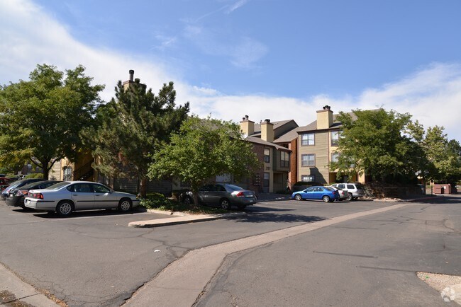
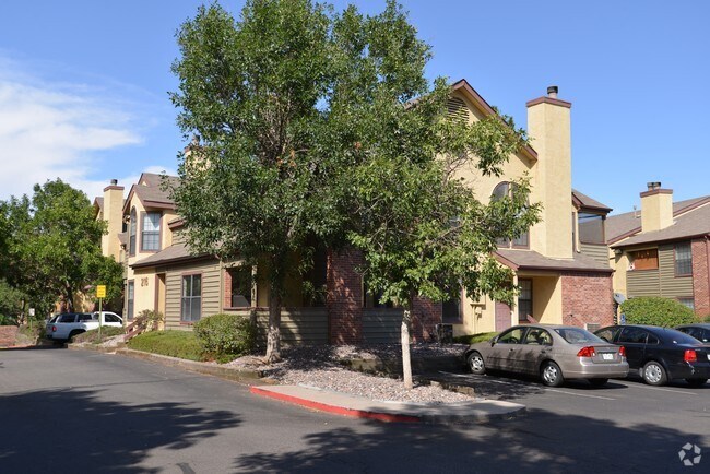
Property Detail
2075 S Paris Way
Denver-Aurora-Centennial, CO
SUBDIVISIONCD 018105 SUBDIVISIONNAME CRICKET SUB 5TH FLG BLOCK 001 LOT 001 LOT 1 BLK 1 CRICKET SUB 5TH FLG TOG WITH THAT PART OF LOT 2 BLK 1 CRICKET SUB 3RD FLG DESC AS BEG 55 FT W & 870 FT M/L S OF NE COR OF NE 1/4 SEC 26-4-67 TH W 26.24 FT TH ALG C
1973-26-1-44-002
Arapahoe
Apartment
Colorado
B and X Area of moderate flood hazard, usually the area between the limits of the 100-year and 500-year floods.
001,1
0
15.68 AC
2026
Village East
080300
Denver
295,573 SF
NEARBY LISTINGS FOR SALE OR LEASE
-
-
View all Aurora listings for sale on LoopNet.com
DEMOGRAPHICS near 2075 S Paris Way
1 mile
3 mile
5 mile
2025 Total Population
19,675
179,311
469,925
2030 Population
19,910
182,939
479,162
Pop Growth 2025-2030
+ 1.19%
+ 2.02%
+ 1.97%
Average Age
42
39
39
2025 Total Households
7,996
77,055
193,758
HH Growth 2025-2030
+ 1.20%
+ 2.11%
+ 2.12%
Median Household Inc
$85,696
$73,000
$79,161
Avg Household Size
2.40
2.20
2.30
2025 Avg HH Vehicles
2.00
2.00
2.00
Median Home Value
$477,352
$430,935
$476,805
Median Year Built
1979
1981
1981
Nearby Places
Map Layers
Map Styles
 Street
 Aerial
Layers
 Traffic
 Biking
Places
Listings with unknown addresses are not visible on the map
- Restaurants
- Banks
- Shops
- Fitness
- Groceries
PUBLIC TRANSPORTATION
COMMUTER RAIL
Peoria Station Track 1 (Union Station to Denver Airport Station - Regional Transportation District)
Drive
Walk
Distance
Peoria Station Track 1 (Union Station to Denver Airport Station - Regional Transportation District)
15 min
9.9 mi
Peoria Station Track 2 (Union Station to Denver Airport Station - Regional Transportation District)
Drive
Walk
Distance
Peoria Station Track 2 (Union Station to Denver Airport Station - Regional Transportation District)
15 min
9.9 mi
AIRPORT
Denver International
Drive
Walk
Distance
Denver International
28 min
21.6 mi
Freight Ports
Tulsa Port Of Catoosa
Drive
Walk
Distance
Tulsa Port Of Catoosa
724 min
704.3 mi
Nearby Properties
Address
Land Use
TOTAL SIZE
Lot Size
Zoning
Address
Land Use
TOTAL SIZE
Lot Size
Zoning
496,493 SF
33.45 AC
Address
Land Use
TOTAL SIZE
Lot Size
Zoning
201,600 SF
44.67 AC
R1
Address
Land Use
TOTAL SIZE
Lot Size
Zoning
476,186 SF
42.62 AC
Address
Land Use
TOTAL SIZE
Lot Size
Zoning
557,843 SF
21.35 AC
PUD
Address
Land Use
TOTAL SIZE
Lot Size
Zoning
315,058 SF
36.85 AC
RPCZD
Address
Land Use
TOTAL SIZE
Lot Size
Zoning
613,600 SF
29.40 AC
R-3
Address
Land Use
TOTAL SIZE
Lot Size
Zoning
277,985 SF
19.07 AC
Address
Land Use
TOTAL SIZE
Lot Size
Zoning
478,994 SF
26.07 AC
Address
Land Use
TOTAL SIZE
Lot Size
Zoning
540,380 SF
26.03 AC
RR3
Address
Land Use
TOTAL SIZE
Lot Size
Zoning
205,250 SF
10 AC
I-A
Address
Land Use
TOTAL SIZE
Lot Size
Zoning
138,750 SF
12.17 AC
OS-A
Address
Land Use
TOTAL SIZE
Lot Size
Zoning
49,627 SF
4.18 AC
B-2
Address
Land Use
TOTAL SIZE
Lot Size
Zoning
209,690 SF
7.21 AC
S-SU-D
Address
Land Use
TOTAL SIZE
Lot Size
Zoning
521,364 SF
14.88 AC
PUD
Address
Land Use
TOTAL SIZE
Lot Size
Zoning
77,648 SF
6.21 AC
RM1
Address
Land Use
TOTAL SIZE
Lot Size
Zoning
506,272 SF
20.38 AC
PUD
Address
Land Use
TOTAL SIZE
Lot Size
Zoning
1,344,255 SF
15.88 AC
AMU
Address
Land Use
TOTAL SIZE
Lot Size
Zoning
383,436 SF
9.77 AC
Address
Land Use
TOTAL SIZE
Lot Size
Zoning
462,048 SF
5.34 AC
RB3
Address
Land Use
TOTAL SIZE
Lot Size
Zoning
649,712 SF
47.31 AC
Address
Land Use
TOTAL SIZE
Lot Size
Zoning
78,876 SF
0.05 AC
C-MX
Address
Land Use
TOTAL SIZE
Lot Size
Zoning
333,696 SF
17.52 AC
PUD
Address
Land Use
TOTAL SIZE
Lot Size
Zoning
105,809 SF
48.79 AC
Address
Land Use
TOTAL SIZE
Lot Size
Zoning
562,766 SF
7.77 AC
Address
Land Use
TOTAL SIZE
Lot Size
Zoning
127,530 SF
20.76 AC
Address
Land Use
TOTAL SIZE
Lot Size
Zoning
350,692 SF
13.51 AC
R-2-A
Address
Land Use
TOTAL SIZE
Lot Size
Zoning
353,956 SF
8.28 AC
R-3
Address
Land Use
TOTAL SIZE
Lot Size
Zoning
145,510 SF
9.61 AC
Address
Land Use
TOTAL SIZE
Lot Size
Zoning
282,505 SF
15.43 AC
PUD
Address
Land Use
TOTAL SIZE
Lot Size
Zoning
413,049 SF
19.62 AC
The World's #1 Commercial Real Estate Marketplace
Connect with us
© 2026 CoStar Group
The information above has been obtained from sources believed reliable. While we do not doubt its accuracy we have not verified it and make no guarantee, warranty or representation about it. It is your responsibility to independently confirm its accuracy and completeness. Any projections, opinions, assumptions, or estimates used are for example only and do not represent the current or future performance of the property. The value of this transaction to you depends on tax and other factors which should be evaluated by your tax, financial, and legal advisors. You and your advisors should conduct a careful, independent investigation of the property to determine to your satisfaction the suitability of the property for your needs.