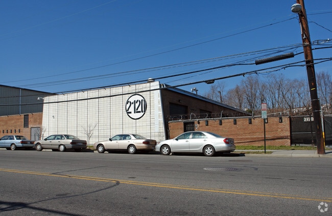
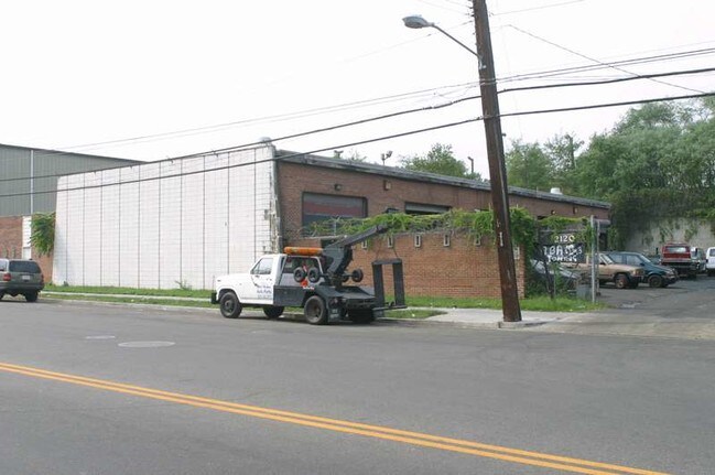
Property Record
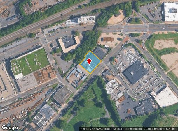
2120 W Virginia Ave Ne, Washington, DC 20002

NEARBY LISTINGS FOR SALE OR LEASE
Property Detail
2120 W Virginia Ave Ne
Washington-Arlington-Alexandria, DC-VA-MD-WV
Brentwood
4098-0246
SQUARE 4098 LOT 0246 NBHD: BRENTWOOD
Warehouse
District of Columbia
X
District of Columbia
1100010036C
246
2025
0.65 AC
2025
Northeast
008803
Washington, DC
12,508 SF
DEMOGRAPHICS near 2120 W Virginia Ave Ne
1 Mile
3 Mile
5 Mile
2024 Total Population
25,463
308,938
734,807
2029 Population
23,832
285,328
684,752
Pop Growth 2024-2029
(6.41%)
(7.64%)
(6.81%)
Average Age
38
37
37
2024 Total Households
10,834
142,048
319,725
HH Growth 2024-2029
(6.88%)
(8.37%)
(7.80%)
Median Household Inc
$67,203
$94,931
$87,664
Avg Household Size
2.10
2.00
2.20
2024 Avg HH Vehicles
1.00
1.00
1.00
Median Home Value
$629,575
$676,265
$561,158
Median Year Built
1953
1960
1959
Nearby Places
Map Layers
Map Styles
 Street
 Aerial
- Restaurants
- Banks
- Shops
- Fitness
- Groceries
PUBLIC TRANSPORTATION
COMMUTER RAIL
Lead (Fredericksburg Line - Virginia Railway Express, Manassas Line - Virginia Railway Express)
DRIVE
WALK
Distance
Lead (Fredericksburg Line - Virginia Railway Express, Manassas Line - Virginia Railway Express)
4 min
2.7 mi
Union Station (Brunswick Line - Maryland Area Regional Commuter Trains (The MARC), Camden Line - Maryland Area Regional Commuter Trains (The MARC), Fredericksburg Line - Maryland Area Regional Commuter Trains (The MARC), Manassas Line - Maryland Area Regional Commuter Trains (The MARC), Penn Line - Maryland Area Regional Commuter Trains (The MARC), Red Line - Maryland Area Regional Commuter Trains (The MARC))
DRIVE
WALK
Distance
Union Station (Brunswick Line - Maryland Area Regional Commuter Trains (The MARC), Camden Line - Maryland Area Regional Commuter Trains (The MARC), Fredericksburg Line - Maryland Area Regional Commuter Trains (The MARC), Manassas Line - Maryland Area Regional Commuter Trains (The MARC), Penn Line - Maryland Area Regional Commuter Trains (The MARC), Red Line - Maryland Area Regional Commuter Trains (The MARC))
6 min
2.9 mi
AIRPORT
Ronald Reagan Washington Ntl
DRIVE
WALK
Distance
Ronald Reagan Washington Ntl
15 min
8.0 mi
Baltimore/Washington International Thurgood Marshall
DRIVE
WALK
Distance
Baltimore/Washington International Thurgood Marshall
41 min
28.4 mi
Washington Dulles International
DRIVE
WALK
Distance
Washington Dulles International
49 min
30.8 mi
Freight Ports
Port of Baltimore
DRIVE
WALK
Distance
Port of Baltimore
51 min
35.0 mi
Nearby Properties
Address
Land Use
TOTAL SIZE
Lot Size
Zoning
Address
Land Use
TOTAL SIZE
Lot Size
Zoning
2,300,000 SF
1.60 AC
D-5-R
Address
Land Use
TOTAL SIZE
Lot Size
Zoning
5,483 SF
88.76 AC
GOV
Address
Land Use
TOTAL SIZE
Lot Size
Zoning
1,517,010 SF
70.25 AC
UNZONED
Address
Land Use
TOTAL SIZE
Lot Size
Zoning
142 AC
GOV
Address
Land Use
TOTAL SIZE
Lot Size
Zoning
63.89 AC
GOV
Address
Land Use
TOTAL SIZE
Lot Size
Zoning
58,289 SF
418.97 AC
MU-4;PDR-1
Address
Land Use
TOTAL SIZE
Lot Size
Zoning
1,583,364 SF
276.66 AC
UNZONED
Address
Land Use
TOTAL SIZE
Lot Size
Zoning
262,673 SF
5.35 AC
D-7
Address
Land Use
TOTAL SIZE
Lot Size
Zoning
42.57 AC
GOV
Address
Land Use
TOTAL SIZE
Lot Size
Zoning
1,043,058 SF
4.03 AC
UNZONED
Address
Land Use
TOTAL SIZE
Lot Size
Zoning
1,738,573 SF
2.11 AC
D-7
Address
Land Use
TOTAL SIZE
Lot Size
Zoning
1,081,367 SF
6.46 AC
UNZONED
Address
Land Use
TOTAL SIZE
Lot Size
Zoning
185,826 SF
9.40 AC
UNZONED
Address
Land Use
TOTAL SIZE
Lot Size
Zoning
2,058,692 SF
4.77 AC
UNZONED
Address
Land Use
TOTAL SIZE
Lot Size
Zoning
1,015,833 SF
1.60 AC
D-7
Address
Land Use
TOTAL SIZE
Lot Size
Zoning
2,247,684 SF
6.39 AC
D-4-R
Address
Land Use
TOTAL SIZE
Lot Size
Zoning
607,735 SF
8.94 AC
PDR-3;UNZO
Address
Land Use
TOTAL SIZE
Lot Size
Zoning
758,000 SF
2.22 AC
D-4-R;MU-7
Address
Land Use
TOTAL SIZE
Lot Size
Zoning
1,562,988 SF
15.33 AC
MU-10 (IZ+
Address
Land Use
TOTAL SIZE
Lot Size
Zoning
2,542,436 SF
6.39 AC
MU-2;MU-4;
Address
Land Use
TOTAL SIZE
Lot Size
Zoning
479,505 SF
5 AC
D-6-R
Address
Land Use
TOTAL SIZE
Lot Size
Zoning
1,375,218 SF
3.55 AC
D-4
Address
Land Use
TOTAL SIZE
Lot Size
Zoning
1,600,300 SF
10.35 AC
D-3
Address
Land Use
TOTAL SIZE
Lot Size
Zoning
1,642,951 SF
95.12 AC
RF-1
Address
Land Use
TOTAL SIZE
Lot Size
Zoning
561,068 SF
1.39 AC
D-3
Address
Land Use
TOTAL SIZE
Lot Size
Zoning
4.87 AC
D-6
Address
Land Use
TOTAL SIZE
Lot Size
Zoning
512,068 SF
1.36 AC
D-5-R
Address
Land Use
TOTAL SIZE
Lot Size
Zoning
787,000 SF
1.17 AC
D-7
Address
Land Use
TOTAL SIZE
Lot Size
Zoning
95.32 AC
RA-1
Address
Land Use
TOTAL SIZE
Lot Size
Zoning
730,233 SF
4.78 AC
UNZONED
The World's #1 Commercial Real Estate Marketplace
Connect with us
© 2025 CoStar Group
The information above has been obtained from sources believed reliable. While we do not doubt its accuracy we have not verified it and make no guarantee, warranty or representation about it. It is your responsibility to independently confirm its accuracy and completeness. Any projections, opinions, assumptions, or estimates used are for example only and do not represent the current or future performance of the property. The value of this transaction to you depends on tax and other factors which should be evaluated by your tax, financial, and legal advisors. You and your advisors should conduct a careful, independent investigation of the property to determine to your satisfaction the suitability of the property for your needs.