Property Record
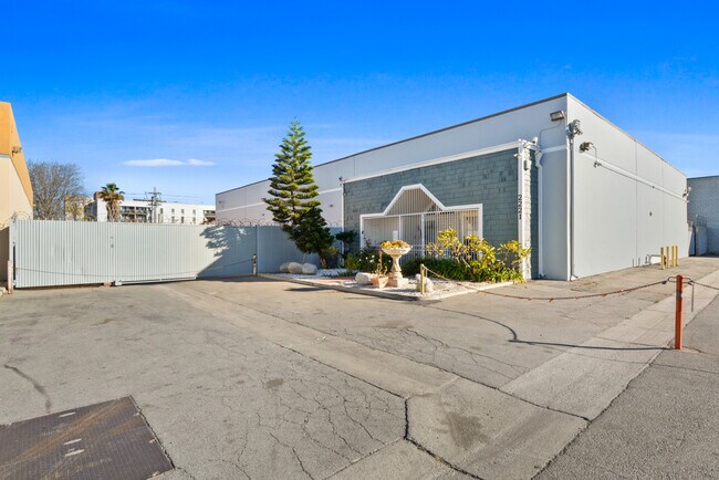
2221 Cape Cod Way, Santa Ana, CA 92703


Property Detail
2221 Cape Cod Way
007-120-33
P BK 120 PG 6 PAR 22
Industrialgeneral
Orange
M1
California
2024
0.56 AC
2025
Santa Ana
074802
Orange County (California)
8,208 SF
Anaheim-Santa Ana-Irvine, CA
NEARBY LISTINGS FOR SALE OR LEASE
DEMOGRAPHICS near 2221 Cape Cod Way
1 mile
3 mile
5 mile
2025 Total Population
48,704
330,151
706,882
2030 Population
48,219
327,671
704,873
Pop Growth 2025-2030
(1.00%)
(0.75%)
(0.28%)
Average Age
36
38
38
2025 Total Households
9,659
80,008
199,230
HH Growth 2025-2030
(1.36%)
(0.88%)
(0.30%)
Median Household Inc
$84,078
$88,515
$92,012
Avg Household Size
4.40
3.80
3.30
2025 Avg HH Vehicles
2.00
2.00
2.00
Median Home Value
$603,537
$710,272
$761,127
Median Year Built
1964
1966
1969
Nearby Places
Map Layers
Map Styles
 Street
 Aerial
Layers
 Traffic
 Biking
Places
Listings with unknown addresses are not visible on the map
- Restaurants
- Banks
- Shops
- Fitness
- Groceries
PUBLIC TRANSPORTATION
COMMUTER RAIL
Santa Ana (Inland Empire-Orange County Line - Southern California Regional Rail Authority (Metrolink), Orange County Line - Southern California Regional Rail Authority (Metrolink))
Drive
Walk
Distance
Santa Ana (Inland Empire-Orange County Line - Southern California Regional Rail Authority (Metrolink), Orange County Line - Southern California Regional Rail Authority (Metrolink))
7 min
2.7 mi
Drive
Walk
Distance
13 min
6.1 mi
AIRPORT
John Wayne/Orange County
Drive
Walk
Distance
John Wayne/Orange County
13 min
6.3 mi
Long Beach (Daugherty Field)
Drive
Walk
Distance
Long Beach (Daugherty Field)
28 min
19.9 mi
Ontario International
Drive
Walk
Distance
Ontario International
50 min
37.0 mi
SALE & LEASE HISTORY
LISTING DATE
SALE/LEASE

Jan 26, 2025
For Sale
Nearby Properties
Address
Land Use
TOTAL SIZE
Lot Size
Zoning
Address
Land Use
TOTAL SIZE
Lot Size
Zoning
31.01 AC
Address
Land Use
TOTAL SIZE
Lot Size
Zoning
2.60 AC
Address
Land Use
TOTAL SIZE
Lot Size
Zoning
41.12 AC
Address
Land Use
TOTAL SIZE
Lot Size
Zoning
46,514 SF
9.18 AC
Address
Land Use
TOTAL SIZE
Lot Size
Zoning
Address
Land Use
TOTAL SIZE
Lot Size
Zoning
11.61 AC
Address
Land Use
TOTAL SIZE
Lot Size
Zoning
Address
Land Use
TOTAL SIZE
Lot Size
Zoning
20.20 AC
Address
Land Use
TOTAL SIZE
Lot Size
Zoning
Address
Land Use
TOTAL SIZE
Lot Size
Zoning
0.52 AC
Address
Land Use
TOTAL SIZE
Lot Size
Zoning
40.76 AC
Address
Land Use
TOTAL SIZE
Lot Size
Zoning
Address
Land Use
TOTAL SIZE
Lot Size
Zoning
Address
Land Use
TOTAL SIZE
Lot Size
Zoning
Address
Land Use
TOTAL SIZE
Lot Size
Zoning
Address
Land Use
TOTAL SIZE
Lot Size
Zoning
Address
Land Use
TOTAL SIZE
Lot Size
Zoning
Address
Land Use
TOTAL SIZE
Lot Size
Zoning
4.94 AC
Address
Land Use
TOTAL SIZE
Lot Size
Zoning
Address
Land Use
TOTAL SIZE
Lot Size
Zoning
156,326 SF
8.83 AC
Address
Land Use
TOTAL SIZE
Lot Size
Zoning
Address
Land Use
TOTAL SIZE
Lot Size
Zoning
2.01 AC
Address
Land Use
TOTAL SIZE
Lot Size
Zoning
Address
Land Use
TOTAL SIZE
Lot Size
Zoning
4.42 AC
Address
Land Use
TOTAL SIZE
Lot Size
Zoning
Address
Land Use
TOTAL SIZE
Lot Size
Zoning
8.37 AC
Address
Land Use
TOTAL SIZE
Lot Size
Zoning
5.38 AC
Address
Land Use
TOTAL SIZE
Lot Size
Zoning
Address
Land Use
TOTAL SIZE
Lot Size
Zoning
0.90 AC
Address
Land Use
TOTAL SIZE
Lot Size
Zoning
0.85 AC
The World's #1 Commercial Real Estate Marketplace
Connect with us
© 2026 CoStar Group
The information above has been obtained from sources believed reliable. While we do not doubt its accuracy we have not verified it and make no guarantee, warranty or representation about it. It is your responsibility to independently confirm its accuracy and completeness. Any projections, opinions, assumptions, or estimates used are for example only and do not represent the current or future performance of the property. The value of this transaction to you depends on tax and other factors which should be evaluated by your tax, financial, and legal advisors. You and your advisors should conduct a careful, independent investigation of the property to determine to your satisfaction the suitability of the property for your needs.