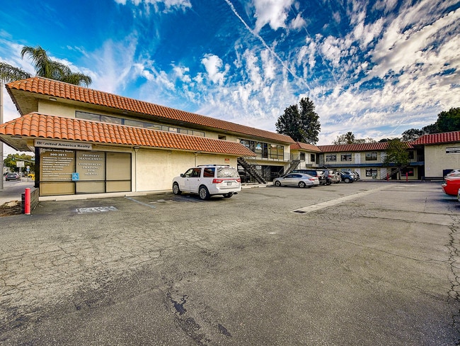
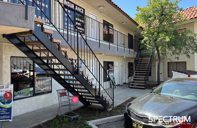
Property Record
22916 Lyons Ave, Newhall, CA 91321


Save to a Folder
{{folder.Name}}
{{folder.ListingIds.length}} Properties
{{folder.ListingIds.length}} Property
Create a New Folder
Current Lease Availabilities
Property Detail
22916 Lyons Ave
2830-016-034
*TR=1059*(EX OF ST) LOT 37
Officebuilding
LOS ANGELES
SCSP
California
AO River or stream flood hazard areas, and areas with a 1% or greater chance of shallow flooding each year. These areas have a 26% chance of flooding over the life of a 30-year mortgage.
37
2025
0.40 AC
2025
Santa Clarita Valley
920312
Los Angeles
12,614 SF
Los Angeles-Long Beach-Glendale, CA
NEARBY LISTINGS FOR SALE OR LEASE
DEMOGRAPHICS near 22916 Lyons Ave
1 mile
3 mile
5 mile
2025 Total Population
15,075
64,199
154,061
2030 Population
14,819
63,694
152,499
Pop Growth 2025-2030
(1.70%)
(0.79%)
(1.01%)
Average Age
38
41
41
2025 Total Households
4,660
22,278
52,791
HH Growth 2025-2030
(2.10%)
(1.04%)
(1.22%)
Median Household Inc
$88,175
$109,182
$117,214
Avg Household Size
3.10
2.80
2.80
2025 Avg HH Vehicles
2.00
2.00
2.00
Median Home Value
$805,388
$774,446
$765,856
Median Year Built
1972
1984
1987
Nearby Places
Map Layers
Map Styles
 Street
 Aerial
Layers
 Traffic
 Biking
Places
Listings with unknown addresses are not visible on the map
- Restaurants
- Banks
- Shops
- Fitness
- Groceries
PUBLIC TRANSPORTATION
COMMUTER RAIL
Newhall (Antelope Valley Line - Southern California Regional Rail Authority (Metrolink))
Drive
Walk
Distance
Newhall (Antelope Valley Line - Southern California Regional Rail Authority (Metrolink))
2 min
11 min
0.6 mi
Santa Clarita (Antelope Valley Line - Southern California Regional Rail Authority (Metrolink))
Drive
Walk
Distance
Santa Clarita (Antelope Valley Line - Southern California Regional Rail Authority (Metrolink))
8 min
4.6 mi
AIRPORT
Bob Hope
Drive
Walk
Distance
Bob Hope
25 min
17.7 mi
Freight Ports
The Port of Hueneme
Drive
Walk
Distance
The Port of Hueneme
78 min
54.9 mi
Nearby Properties
Address
Land Use
TOTAL SIZE
Lot Size
Zoning
Address
Land Use
TOTAL SIZE
Lot Size
Zoning
491,654 SF
17.56 AC
SCPI
Address
Land Use
TOTAL SIZE
Lot Size
Zoning
479,178 SF
14.17 AC
SCCR
Address
Land Use
TOTAL SIZE
Lot Size
Zoning
173,298 SF
12.42 AC
LCA25*
Address
Land Use
TOTAL SIZE
Lot Size
Zoning
495,604 SF
38.40 AC
SCI
Address
Land Use
TOTAL SIZE
Lot Size
Zoning
291,344 SF
15.32 AC
LCA2
Address
Land Use
TOTAL SIZE
Lot Size
Zoning
1,014,267 SF
59.95 AC
SCPI
Address
Land Use
TOTAL SIZE
Lot Size
Zoning
245,053 SF
19.81 AC
LCA25*
Address
Land Use
TOTAL SIZE
Lot Size
Zoning
139,196 SF
8.79 AC
SCUR5
Address
Land Use
TOTAL SIZE
Lot Size
Zoning
161,103 SF
4.68 AC
SCUR4
Address
Land Use
TOTAL SIZE
Lot Size
Zoning
143,163 SF
10.48 AC
SCUR3
Address
Land Use
TOTAL SIZE
Lot Size
Zoning
402,480 SF
13.58 AC
SCCN
Address
Land Use
TOTAL SIZE
Lot Size
Zoning
137,361 SF
7.38 AC
SCUR3
Address
Land Use
TOTAL SIZE
Lot Size
Zoning
83,698 SF
8.94 AC
SCPI
Address
Land Use
TOTAL SIZE
Lot Size
Zoning
271,399 SF
7.49 AC
LCA25*
Address
Land Use
TOTAL SIZE
Lot Size
Zoning
2,355 SF
497.82 AC
SCSP
Address
Land Use
TOTAL SIZE
Lot Size
Zoning
216,067 SF
25.69 AC
SCBP
Address
Land Use
TOTAL SIZE
Lot Size
Zoning
86,201 SF
3.68 AC
SCUR4
Address
Land Use
TOTAL SIZE
Lot Size
Zoning
138,025 SF
14.51 AC
LCA2
Address
Land Use
TOTAL SIZE
Lot Size
Zoning
245,606 SF
11.67 AC
SCUR4
Address
Land Use
TOTAL SIZE
Lot Size
Zoning
78,596 SF
4.62 AC
SCCR
Address
Land Use
TOTAL SIZE
Lot Size
Zoning
3,840 SF
443.36 AC
SCSP
Address
Land Use
TOTAL SIZE
Lot Size
Zoning
354,338 SF
26.37 AC
SCCR
Address
Land Use
TOTAL SIZE
Lot Size
Zoning
180,492 SF
9.47 AC
SCUR4
Address
Land Use
TOTAL SIZE
Lot Size
Zoning
79,622 SF
1.21 AC
SCPI
Address
Land Use
TOTAL SIZE
Lot Size
Zoning
52,904 SF
3.08 AC
SCPI
Address
Land Use
TOTAL SIZE
Lot Size
Zoning
144,152 SF
2.39 AC
LCA22-A21*
Address
Land Use
TOTAL SIZE
Lot Size
Zoning
106,662 SF
4.04 AC
LCA25*
Address
Land Use
TOTAL SIZE
Lot Size
Zoning
60,614 SF
1.05 AC
SCCR
Address
Land Use
TOTAL SIZE
Lot Size
Zoning
52,194 SF
0.76 AC
SCCP
Address
Land Use
TOTAL SIZE
Lot Size
Zoning
129,420 SF
23.25 AC
SCBP
The World's #1 Commercial Real Estate Marketplace
Connect with us
© 2026 CoStar Group
The information above has been obtained from sources believed reliable. While we do not doubt its accuracy we have not verified it and make no guarantee, warranty or representation about it. It is your responsibility to independently confirm its accuracy and completeness. Any projections, opinions, assumptions, or estimates used are for example only and do not represent the current or future performance of the property. The value of this transaction to you depends on tax and other factors which should be evaluated by your tax, financial, and legal advisors. You and your advisors should conduct a careful, independent investigation of the property to determine to your satisfaction the suitability of the property for your needs.