Property Record
23044 N 7Th St, Phoenix, AZ 85024
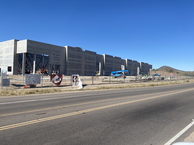

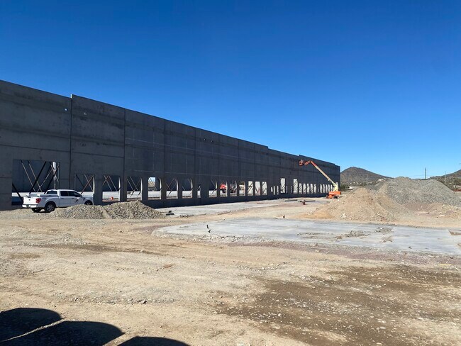

Property Detail
23044 N 7Th St
Phoenix-Mesa-Chandler, AZ
HOPEWELL 7TH PINNACLE MCR 1604-31
209-01-023
MARICOPA
Warehouse
Arizona
A1
1
2025
9.41 AC
2025
Deer Vly/Pinnacle Pk
614900
Phoenix
131,172 SF
NEARBY LISTINGS FOR SALE OR LEASE
DEMOGRAPHICS near 23044 N 7Th St
1 mile
3 mile
5 mile
2025 Total Population
4
44,600
197,107
2030 Population
5
46,376
204,240
Pop Growth 2025-2030
+ 25.00%
+ 3.98%
+ 3.62%
Average Age
0
38
39
2025 Total Households
1
18,239
79,165
HH Growth 2025-2030
0.00%
+ 4.11%
+ 3.72%
Median Household Inc
$0
$91,952
$88,559
Avg Household Size
2.00
2.40
2.40
2025 Avg HH Vehicles
2.00
2.00
2.00
Median Home Value
$0
$449,857
$444,601
Median Year Built
2011
1994
1992
Nearby Places
Map Layers
Map Styles
 Street
 Aerial
Transit
 Traffic
 Biking
Places
Listings with unknown addresses are not visible on the map
- Restaurants
- Banks
- Shops
- Fitness
- Groceries
PUBLIC TRANSPORTATION
AIRPORT
Phoenix Sky Harbor International
Drive
Walk
Distance
Phoenix Sky Harbor International
35 min
25.3 mi
Freight Ports
Port of San Diego
Drive
Walk
Distance
Port of San Diego
412 min
369.7 mi
SALE & LEASE HISTORY
LISTING DATE
SALE/LEASE

Feb 10, 2020
For Lease
Nearby Properties
Address
Land Use
TOTAL SIZE
Lot Size
Zoning
Address
Land Use
TOTAL SIZE
Lot Size
Zoning
132,348 SF
9.16 AC
I-P
Address
Land Use
TOTAL SIZE
Lot Size
Zoning
Address
Land Use
TOTAL SIZE
Lot Size
Zoning
267,397 SF
108.70 AC
R-43AG
Address
Land Use
TOTAL SIZE
Lot Size
Zoning
289,901 SF
12.30 AC
A-1
Address
Land Use
TOTAL SIZE
Lot Size
Zoning
471,671 SF
18.04 AC
I-1
Address
Land Use
TOTAL SIZE
Lot Size
Zoning
389,967 SF
245.48 AC
I-1
Address
Land Use
TOTAL SIZE
Lot Size
Zoning
8,469 SF
215.03 AC
Address
Land Use
TOTAL SIZE
Lot Size
Zoning
264,909 SF
219.16 AC
I-1
Address
Land Use
TOTAL SIZE
Lot Size
Zoning
968,899 SF
76.37 AC
I-1
Address
Land Use
TOTAL SIZE
Lot Size
Zoning
338,640 SF
10.39 AC
R-4A
Address
Land Use
TOTAL SIZE
Lot Size
Zoning
307,891 SF
15.89 AC
Address
Land Use
TOTAL SIZE
Lot Size
Zoning
312,070 SF
20.04 AC
A1
Address
Land Use
TOTAL SIZE
Lot Size
Zoning
242,144 SF
29.78 AC
RE-43
Address
Land Use
TOTAL SIZE
Lot Size
Zoning
291,059 SF
16.54 AC
I-1
Address
Land Use
TOTAL SIZE
Lot Size
Zoning
240.86 AC
IND.PK.
Address
Land Use
TOTAL SIZE
Lot Size
Zoning
355,606 SF
11.35 AC
C-C
Address
Land Use
TOTAL SIZE
Lot Size
Zoning
244,787 SF
5.83 AC
Address
Land Use
TOTAL SIZE
Lot Size
Zoning
45,487 SF
117.90 AC
S1
Address
Land Use
TOTAL SIZE
Lot Size
Zoning
255,482 SF
15.30 AC
M-H
Address
Land Use
TOTAL SIZE
Lot Size
Zoning
189,524 SF
13.80 AC
I-P
Address
Land Use
TOTAL SIZE
Lot Size
Zoning
240,311 SF
14.42 AC
R-43AG
Address
Land Use
TOTAL SIZE
Lot Size
Zoning
181,170 SF
7.09 AC
I-P
Address
Land Use
TOTAL SIZE
Lot Size
Zoning
196,485 SF
8.98 AC
Address
Land Use
TOTAL SIZE
Lot Size
Zoning
232,395 SF
17.14 AC
CPGCP
Address
Land Use
TOTAL SIZE
Lot Size
Zoning
217,379 SF
16.13 AC
I-1
Address
Land Use
TOTAL SIZE
Lot Size
Zoning
63,192 SF
94.91 AC
RE43
Address
Land Use
TOTAL SIZE
Lot Size
Zoning
301,696 SF
21.14 AC
I-1
Address
Land Use
TOTAL SIZE
Lot Size
Zoning
135,370 SF
7.18 AC
I-1
Address
Land Use
TOTAL SIZE
Lot Size
Zoning
131,074 SF
7.32 AC
I-1
Address
Land Use
TOTAL SIZE
Lot Size
Zoning
254,079 SF
21.23 AC
The World's #1 Commercial Real Estate Marketplace
Connect with us
© 2026 CoStar Group
The information above has been obtained from sources believed reliable. While we do not doubt its accuracy we have not verified it and make no guarantee, warranty or representation about it. It is your responsibility to independently confirm its accuracy and completeness. Any projections, opinions, assumptions, or estimates used are for example only and do not represent the current or future performance of the property. The value of this transaction to you depends on tax and other factors which should be evaluated by your tax, financial, and legal advisors. You and your advisors should conduct a careful, independent investigation of the property to determine to your satisfaction the suitability of the property for your needs.