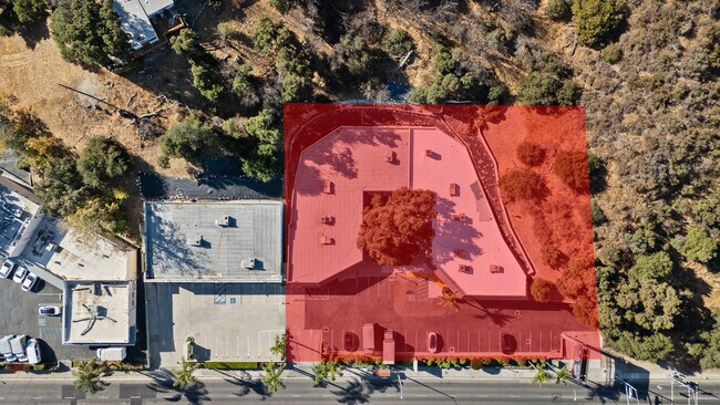
Property Record
23681 Newhall Ave, Newhall, CA 91321
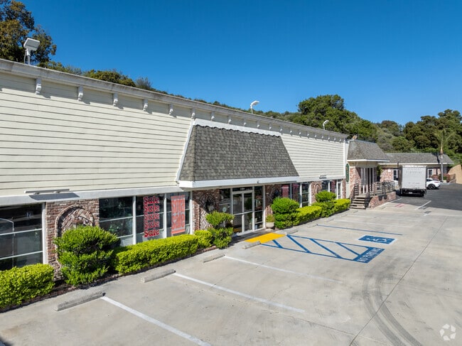

This Property Is For Sale
Current Lease Availabilities
General Retail LEASE
$22.20 - $24.00 SF/YR
1,500 - 9,200 SF
Property Detail
23681 Newhall Ave
2827-004-027
TR=2703 FOR DESC SEE ASSESSORS MAPS POR OF LOTS 5 AND 51
Storemultistory
LOS ANGELES
SCMX-C
California
C and X Area of minimal flood hazard, usually depicted on FIRMs as above the 500-year flood level.
5,51
2024
1.06 AC
2025
Santa Clarita Valley
920312
Los Angeles
12,847 SF
Los Angeles-Long Beach-Glendale, CA
NEARBY LISTINGS FOR SALE OR LEASE
DEMOGRAPHICS near 23681 Newhall Ave
1 mile
3 mile
5 mile
2025 Total Population
9,805
44,228
164,583
2030 Population
9,771
43,922
162,990
Pop Growth 2025-2030
(0.35%)
(0.69%)
(0.97%)
Average Age
36
40
40
2025 Total Households
2,811
14,348
55,366
HH Growth 2025-2030
(0.60%)
(0.96%)
(1.18%)
Median Household Inc
$89,791
$110,211
$112,294
Avg Household Size
3.30
2.90
2.90
2025 Avg HH Vehicles
2.00
2.00
2.00
Median Home Value
$666,164
$764,717
$754,104
Median Year Built
1986
1979
1986
Nearby Places
Map Layers
Map Styles
 Street
 Aerial
Layers
 Traffic
 Biking
Places
Listings with unknown addresses are not visible on the map
- Restaurants
- Banks
- Shops
- Fitness
- Groceries
PUBLIC TRANSPORTATION
COMMUTER RAIL
Newhall (Antelope Valley Line - Southern California Regional Rail Authority (Metrolink))
Drive
Walk
Distance
Newhall (Antelope Valley Line - Southern California Regional Rail Authority (Metrolink))
4 min
20 min
1.0 mi
Santa Clarita (Antelope Valley Line - Southern California Regional Rail Authority (Metrolink))
Drive
Walk
Distance
Santa Clarita (Antelope Valley Line - Southern California Regional Rail Authority (Metrolink))
11 min
6.0 mi
AIRPORT
Bob Hope
Drive
Walk
Distance
Bob Hope
22 min
16.4 mi
Freight Ports
The Port of Hueneme
Drive
Walk
Distance
The Port of Hueneme
76 min
53.1 mi
Nearby Properties
Address
Land Use
TOTAL SIZE
Lot Size
Zoning
Address
Land Use
TOTAL SIZE
Lot Size
Zoning
491,654 SF
17.56 AC
SCPI
Address
Land Use
TOTAL SIZE
Lot Size
Zoning
161,103 SF
4.68 AC
SCUR4
Address
Land Use
TOTAL SIZE
Lot Size
Zoning
143,163 SF
10.48 AC
SCUR3
Address
Land Use
TOTAL SIZE
Lot Size
Zoning
137,361 SF
7.38 AC
SCUR3
Address
Land Use
TOTAL SIZE
Lot Size
Zoning
83,698 SF
8.94 AC
SCPI
Address
Land Use
TOTAL SIZE
Lot Size
Zoning
2,355 SF
497.82 AC
SCSP
Address
Land Use
TOTAL SIZE
Lot Size
Zoning
3,840 SF
443.36 AC
SCSP
Address
Land Use
TOTAL SIZE
Lot Size
Zoning
79,622 SF
1.21 AC
SCPI
Address
Land Use
TOTAL SIZE
Lot Size
Zoning
52,904 SF
3.08 AC
SCPI
Address
Land Use
TOTAL SIZE
Lot Size
Zoning
144,152 SF
2.39 AC
LCA22-A21*
Address
Land Use
TOTAL SIZE
Lot Size
Zoning
52,194 SF
0.76 AC
SCCP
Address
Land Use
TOTAL SIZE
Lot Size
Zoning
180,584 SF
6.35 AC
SCUR3
Address
Land Use
TOTAL SIZE
Lot Size
Zoning
62,000 SF
2.98 AC
Address
Land Use
TOTAL SIZE
Lot Size
Zoning
55,156 SF
2.08 AC
LACC3DP
Address
Land Use
TOTAL SIZE
Lot Size
Zoning
209,119 SF
3.24 AC
SCBP
Address
Land Use
TOTAL SIZE
Lot Size
Zoning
169,585 SF
9.16 AC
SCBP
Address
Land Use
TOTAL SIZE
Lot Size
Zoning
187,990 SF
9.18 AC
SCBP
Address
Land Use
TOTAL SIZE
Lot Size
Zoning
51,597 SF
2.13 AC
SCCP
Address
Land Use
TOTAL SIZE
Lot Size
Zoning
75,251 SF
1.71 AC
SCUR3
Address
Land Use
TOTAL SIZE
Lot Size
Zoning
57,232 SF
0.27 AC
SCSP
Address
Land Use
TOTAL SIZE
Lot Size
Zoning
135,228 SF
7.80 AC
SCUR3
Address
Land Use
TOTAL SIZE
Lot Size
Zoning
52,633 SF
1.35 AC
SCCP
Address
Land Use
TOTAL SIZE
Lot Size
Zoning
42,767 SF
0.26 AC
SCSP
Address
Land Use
TOTAL SIZE
Lot Size
Zoning
33,578 SF
SCCP
Address
Land Use
TOTAL SIZE
Lot Size
Zoning
188,057 SF
2.70 AC
SCCP
Address
Land Use
TOTAL SIZE
Lot Size
Zoning
48,867 SF
1.26 AC
SCUR2
Address
Land Use
TOTAL SIZE
Lot Size
Zoning
61,663 SF
2.98 AC
C2
Address
Land Use
TOTAL SIZE
Lot Size
Zoning
110,126 SF
6.31 AC
SCBP
Address
Land Use
TOTAL SIZE
Lot Size
Zoning
125,282 SF
8.17 AC
SCPI
The World's #1 Commercial Real Estate Marketplace
Connect with us
© 2026 CoStar Group
The information above has been obtained from sources believed reliable. While we do not doubt its accuracy we have not verified it and make no guarantee, warranty or representation about it. It is your responsibility to independently confirm its accuracy and completeness. Any projections, opinions, assumptions, or estimates used are for example only and do not represent the current or future performance of the property. The value of this transaction to you depends on tax and other factors which should be evaluated by your tax, financial, and legal advisors. You and your advisors should conduct a careful, independent investigation of the property to determine to your satisfaction the suitability of the property for your needs.