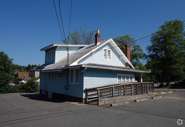
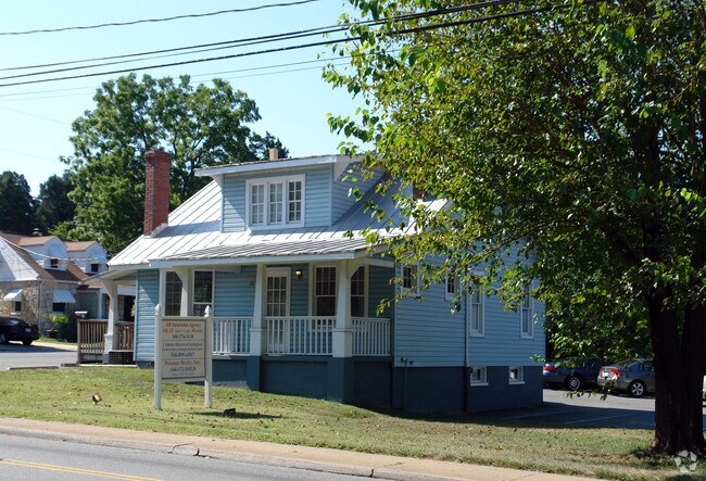
Property Record
24 Butler Rd, Fredericksburg, VA 22405

Save to a Folder
{{folder.Name}}
{{folder.ListingIds.length}} Properties
{{folder.ListingIds.length}} Property
Create a New Folder
Property Detail
24 Butler Rd
53D-1-48
TM 53D-1-48 7034 SQ FT LR180011948
Countyproperty
Stafford
B3
Virginia
B and X Area of moderate flood hazard, usually the area between the limits of the 100-year and 500-year floods.
0.16 AC
0
Stafford County
2025
Washington, DC
010406
Washington-Arlington-Alexandria, DC-VA-MD-WV
NEARBY LISTINGS FOR SALE OR LEASE
DEMOGRAPHICS near 24 Butler Rd
1 mile
3 mile
5 mile
2025 Total Population
5,131
56,785
100,957
2030 Population
5,489
60,259
107,146
Pop Growth 2025-2030
+ 6.98%
+ 6.12%
+ 6.13%
Average Age
40
38
39
2025 Total Households
2,038
21,817
37,658
HH Growth 2025-2030
+ 7.02%
+ 6.46%
+ 6.41%
Median Household Inc
$109,291
$101,383
$105,068
Avg Household Size
2.50
2.50
2.60
2025 Avg HH Vehicles
2.00
2.00
2.00
Median Home Value
$427,529
$436,737
$435,162
Median Year Built
1979
1990
1993
Nearby Places
Map Layers
Map Styles
 Street
 Aerial
Layers
 Traffic
 Biking
Places
Listings with unknown addresses are not visible on the map
- Restaurants
- Banks
- Shops
- Fitness
- Groceries
PUBLIC TRANSPORTATION
COMMUTER RAIL
Drive
Walk
Distance
6 min
2.5 mi
Drive
Walk
Distance
8 min
3.7 mi
Nearby Properties
Address
Land Use
TOTAL SIZE
Lot Size
Zoning
Address
Land Use
TOTAL SIZE
Lot Size
Zoning
945,573 SF
22.11 AC
PDMC
Address
Land Use
TOTAL SIZE
Lot Size
Zoning
427,478 SF
15.36 AC
PDC
Address
Land Use
TOTAL SIZE
Lot Size
Zoning
14,500 SF
CT
Address
Land Use
TOTAL SIZE
Lot Size
Zoning
343,471 SF
14.61 AC
CD
Address
Land Use
TOTAL SIZE
Lot Size
Zoning
121,832 SF
0.23 AC
R2
Address
Land Use
TOTAL SIZE
Lot Size
Zoning
282,451 SF
110.89 AC
A1
Address
Land Use
TOTAL SIZE
Lot Size
Zoning
421,851 SF
7.05 AC
PDMU
Address
Land Use
TOTAL SIZE
Lot Size
Zoning
198,000 SF
23.67 AC
R2
Address
Land Use
TOTAL SIZE
Lot Size
Zoning
271,103 SF
16.84 AC
PDC
Address
Land Use
TOTAL SIZE
Lot Size
Zoning
234,016 SF
13.48 AC
PDC
Address
Land Use
TOTAL SIZE
Lot Size
Zoning
248,662 SF
8.56 AC
PDC
Address
Land Use
TOTAL SIZE
Lot Size
Zoning
252,616 SF
22.31 AC
R16
Address
Land Use
TOTAL SIZE
Lot Size
Zoning
80,000 SF
0.51 AC
R2
Address
Land Use
TOTAL SIZE
Lot Size
Zoning
143,003 SF
38.64 AC
R2
Address
Land Use
TOTAL SIZE
Lot Size
Zoning
230,664 SF
60.21 AC
A2
Address
Land Use
TOTAL SIZE
Lot Size
Zoning
105,564 SF
1.07 AC
R2
Address
Land Use
TOTAL SIZE
Lot Size
Zoning
265,289 SF
30.63 AC
R8
Address
Land Use
TOTAL SIZE
Lot Size
Zoning
188 SF
14.96 AC
R2
Address
Land Use
TOTAL SIZE
Lot Size
Zoning
21.89 AC
PDC
Address
Land Use
TOTAL SIZE
Lot Size
Zoning
156,241 SF
12.73 AC
R16
Address
Land Use
TOTAL SIZE
Lot Size
Zoning
168 SF
11.77 AC
R2
Address
Land Use
TOTAL SIZE
Lot Size
Zoning
100 AC
R2
Address
Land Use
TOTAL SIZE
Lot Size
Zoning
187,097 SF
16.66 AC
R16
Address
Land Use
TOTAL SIZE
Lot Size
Zoning
76,950 SF
0.47 AC
CD
Address
Land Use
TOTAL SIZE
Lot Size
Zoning
610,866 SF
37.59 AC
M1
Address
Land Use
TOTAL SIZE
Lot Size
Zoning
56,004 SF
0.46 AC
R2
Address
Land Use
TOTAL SIZE
Lot Size
Zoning
164,579 SF
11.81 AC
M1
Address
Land Use
TOTAL SIZE
Lot Size
Zoning
Address
Land Use
TOTAL SIZE
Lot Size
Zoning
30,964 SF
68.81 AC
R2
Address
Land Use
TOTAL SIZE
Lot Size
Zoning
75,441 SF
0.27 AC
R2
The World's #1 Commercial Real Estate Marketplace
Connect with us
© 2026 CoStar Group
The information above has been obtained from sources believed reliable. While we do not doubt its accuracy we have not verified it and make no guarantee, warranty or representation about it. It is your responsibility to independently confirm its accuracy and completeness. Any projections, opinions, assumptions, or estimates used are for example only and do not represent the current or future performance of the property. The value of this transaction to you depends on tax and other factors which should be evaluated by your tax, financial, and legal advisors. You and your advisors should conduct a careful, independent investigation of the property to determine to your satisfaction the suitability of the property for your needs.