Property Record
2404 Cornwall St, Savannah, GA 31415
NEARBY LISTINGS FOR SALE OR LEASE
Property Detail
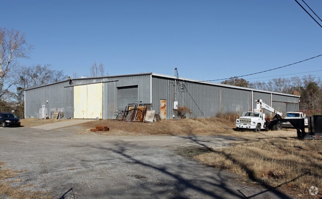
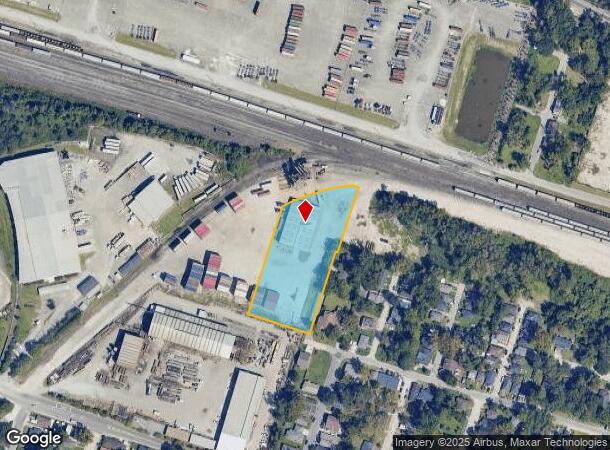
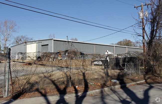
2404 Cornwall St
2004804005
Telfair Rd/Loui
Publicstorage
TCT NW CORNER CORNWALL & SHEFFIE LD AVE GIBBONS WD
X
Chatham
45053C0550D
Georgia
2024
2.21 AC
2025
Greater Savannah
000601
Savannah
15,000 SF
Savannah, GA
DEMOGRAPHICS near 2404 Cornwall St
1 Mile
3 Mile
5 Mile
2024 Total Population
8,624
67,487
113,202
2029 Population
9,087
71,097
118,484
Pop Growth 2024-2029
+ 5.37%
+ 5.35%
+ 4.67%
Average Age
39
38
38
2024 Total Households
3,184
27,709
46,097
HH Growth 2024-2029
+ 5.75%
+ 5.75%
+ 5.02%
Median Household Inc
$35,607
$46,456
$47,313
Avg Household Size
2.30
2.20
2.20
2024 Avg HH Vehicles
1.00
1.00
1.00
Median Home Value
$91,487
$247,827
$196,084
Median Year Built
1964
1958
1961
Nearby Places
Map Layers
Map Styles
 Street
 Aerial
- Restaurants
- Banks
- Shops
- Fitness
- Groceries
PUBLIC TRANSPORTATION
COMMUTER RAIL
DRIVE
WALK
Distance
6 min
2.2 mi
AIRPORT
Savannah/Hilton Head International
DRIVE
WALK
Distance
Savannah/Hilton Head International
20 min
10.0 mi
Hilton Head
DRIVE
WALK
Distance
Hilton Head
62 min
38.2 mi
Freight Ports
Georgia Ports - Savannah
DRIVE
WALK
Distance
Georgia Ports - Savannah
17 min
7.0 mi
Nearby Properties
Address
Land Use
TOTAL SIZE
Lot Size
Zoning
Address
Land Use
TOTAL SIZE
Lot Size
Zoning
1,400 SF
6.97 AC
D-X
Address
Land Use
TOTAL SIZE
Lot Size
Zoning
7,500 SF
382.12 AC
I-H
Address
Land Use
TOTAL SIZE
Lot Size
Zoning
22.34 AC
PUDBW
Address
Land Use
TOTAL SIZE
Lot Size
Zoning
453,984 SF
10.42 AC
Address
Land Use
TOTAL SIZE
Lot Size
Zoning
31,396 SF
1.69 AC
BG
Address
Land Use
TOTAL SIZE
Lot Size
Zoning
86,336 SF
1.08 AC
BB
Address
Land Use
TOTAL SIZE
Lot Size
Zoning
40,848 SF
19.50 AC
RIN
Address
Land Use
TOTAL SIZE
Lot Size
Zoning
354,322 SF
6.30 AC
IH
Address
Land Use
TOTAL SIZE
Lot Size
Zoning
489,483 SF
35 AC
PUDB
Address
Land Use
TOTAL SIZE
Lot Size
Zoning
4,930 SF
1.18 AC
I-L
Address
Land Use
TOTAL SIZE
Lot Size
Zoning
421 SF
6.82 AC
PUDBW
Address
Land Use
TOTAL SIZE
Lot Size
Zoning
351,297 SF
2.08 AC
BC1
Address
Land Use
TOTAL SIZE
Lot Size
Zoning
124,080 SF
1.66 AC
BB
Address
Land Use
TOTAL SIZE
Lot Size
Zoning
173,554 SF
0.72 AC
BB
Address
Land Use
TOTAL SIZE
Lot Size
Zoning
33,000 SF
1.92 AC
I-L
Address
Land Use
TOTAL SIZE
Lot Size
Zoning
199,424 SF
2.49 AC
BN
Address
Land Use
TOTAL SIZE
Lot Size
Zoning
116,928 SF
1.10 AC
BB
Address
Land Use
TOTAL SIZE
Lot Size
Zoning
84,560 SF
0.31 AC
BC1
Address
Land Use
TOTAL SIZE
Lot Size
Zoning
479,600 SF
28.24 AC
IH
Address
Land Use
TOTAL SIZE
Lot Size
Zoning
77,610 SF
0.33 AC
BC1
Address
Land Use
TOTAL SIZE
Lot Size
Zoning
245,610 SF
1.10 AC
RIPC
Address
Land Use
TOTAL SIZE
Lot Size
Zoning
92,132 SF
4.92 AC
PUDBW
Address
Land Use
TOTAL SIZE
Lot Size
Zoning
32,190 SF
22.11 AC
PUDBR
Address
Land Use
TOTAL SIZE
Lot Size
Zoning
115,069 SF
1.14 AC
BC1
Address
Land Use
TOTAL SIZE
Lot Size
Zoning
33,432 SF
16.38 AC
PUDB
Address
Land Use
TOTAL SIZE
Lot Size
Zoning
1.07 AC
BG
Address
Land Use
TOTAL SIZE
Lot Size
Zoning
120,084 SF
0.48 AC
BC1
Address
Land Use
TOTAL SIZE
Lot Size
Zoning
8,100 SF
428.50 AC
I-H
Address
Land Use
TOTAL SIZE
Lot Size
Zoning
810 SF
20 AC
Address
Land Use
TOTAL SIZE
Lot Size
Zoning
384,000 SF
48.45 AC
I-H
The World's #1 Commercial Real Estate Marketplace
Connect with us
© 2025 CoStar Group
The information above has been obtained from sources believed reliable. While we do not doubt its accuracy we have not verified it and make no guarantee, warranty or representation about it. It is your responsibility to independently confirm its accuracy and completeness. Any projections, opinions, assumptions, or estimates used are for example only and do not represent the current or future performance of the property. The value of this transaction to you depends on tax and other factors which should be evaluated by your tax, financial, and legal advisors. You and your advisors should conduct a careful, independent investigation of the property to determine to your satisfaction the suitability of the property for your needs.