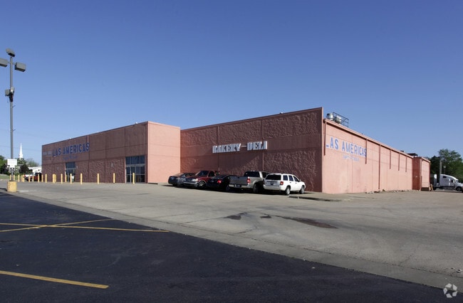
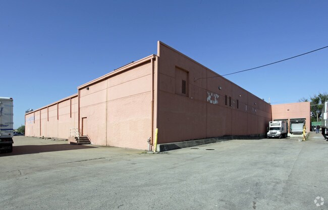
Property Record
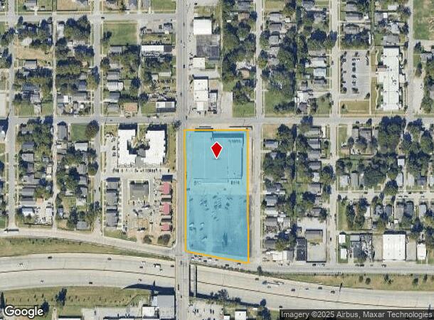
2415 E Admiral Pl, Tulsa, OK 74110
NEARBY LISTINGS FOR SALE OR LEASE
Property Detail
2415 E Admiral Pl
Tulsa, OK
Schlump Addn
37300-93-05-19770
ALL LTS 1 THRU 11 & PRT LTS 12 THRU 14 & ALL LTS 15 THRU 24 BEG NEC LT 1 TH S595 NWLY272.46 NW14.19 N540 E279 POB BLK 1
Warehouse
Tulsa
X
Oklahoma
40143C0240L
1
2025
3.66 AC
2025
Northeast Tulsa
001400
Tulsa
45,030 SF
DEMOGRAPHICS near 2415 E Admiral Pl
1 mile
3 mile
5 mile
2024 Total Population
15,088
94,331
179,087
2029 Population
16,036
98,830
186,772
Pop Growth 2024-2029
+ 6.28%
+ 4.77%
+ 4.29%
Average Age
34
38
38
2024 Total Households
5,367
39,564
75,796
HH Growth 2024-2029
+ 7.02%
+ 5.08%
+ 4.44%
Median Household Inc
$37,405
$46,741
$47,120
Avg Household Size
2.40
2.20
2.20
2024 Avg HH Vehicles
2.00
2.00
2.00
Median Home Value
$73,071
$145,108
$148,588
Median Year Built
1952
1953
1957
Nearby Places
Map Layers
Map Styles
 Street
 Aerial
Transit
 Traffic
 Biking
Places
Listings with unknown addresses are not visible on the map
- Restaurants
- Banks
- Shops
- Fitness
- Groceries
PUBLIC TRANSPORTATION
AIRPORT
Tulsa International
Drive
Walk
Distance
Tulsa International
15 min
7.8 mi
Freight Ports
Drive
Walk
Distance
23 min
16.1 mi
Nearby Properties
Address
Land Use
TOTAL SIZE
Lot Size
Zoning
Address
Land Use
TOTAL SIZE
Lot Size
Zoning
565,000 SF
10.62 AC
CBD
Address
Land Use
TOTAL SIZE
Lot Size
Zoning
1,303,210 SF
7.94 AC
OH
Address
Land Use
TOTAL SIZE
Lot Size
Zoning
1,604,892 SF
208.96 AC
AG
Address
Land Use
TOTAL SIZE
Lot Size
Zoning
1,673,798 SF
90.26 AC
NCU
Address
Land Use
TOTAL SIZE
Lot Size
Zoning
249,092 SF
11.75 AC
CBD
Address
Land Use
TOTAL SIZE
Lot Size
Zoning
692,068 SF
1.03 AC
CBD
Address
Land Use
TOTAL SIZE
Lot Size
Zoning
423,825 SF
23.97 AC
CBD
Address
Land Use
TOTAL SIZE
Lot Size
Zoning
483,697 SF
5.31 AC
CBD
Address
Land Use
TOTAL SIZE
Lot Size
Zoning
247,806 SF
8.40 AC
RS3
Address
Land Use
TOTAL SIZE
Lot Size
Zoning
49,992 SF
33.23 AC
AG
Address
Land Use
TOTAL SIZE
Lot Size
Zoning
528,432 SF
0.01 AC
CBD
Address
Land Use
TOTAL SIZE
Lot Size
Zoning
110,922 SF
1.59 AC
RM2
Address
Land Use
TOTAL SIZE
Lot Size
Zoning
74,284 SF
3.61 AC
IM
Address
Land Use
TOTAL SIZE
Lot Size
Zoning
254,800 SF
2.07 AC
CBD
Address
Land Use
TOTAL SIZE
Lot Size
Zoning
132,305 SF
2.07 AC
CBD
Address
Land Use
TOTAL SIZE
Lot Size
Zoning
114,791 SF
23.40 AC
RE
Address
Land Use
TOTAL SIZE
Lot Size
Zoning
87,606 SF
8.25 AC
CBD
Address
Land Use
TOTAL SIZE
Lot Size
Zoning
238,884 SF
38.79 AC
RS2
Address
Land Use
TOTAL SIZE
Lot Size
Zoning
175,176 SF
1.57 AC
RM2
Address
Land Use
TOTAL SIZE
Lot Size
Zoning
230,620 SF
16.72 AC
RM2
Address
Land Use
TOTAL SIZE
Lot Size
Zoning
303 SF
33.64 AC
RS2
Address
Land Use
TOTAL SIZE
Lot Size
Zoning
266,944 SF
2.07 AC
CBD
Address
Land Use
TOTAL SIZE
Lot Size
Zoning
124,033 SF
4.18 AC
CBD
Address
Land Use
TOTAL SIZE
Lot Size
Zoning
315,434 SF
2.07 AC
CBD
Address
Land Use
TOTAL SIZE
Lot Size
Zoning
355,620 SF
4.78 AC
CBD
Address
Land Use
TOTAL SIZE
Lot Size
Zoning
94,115 SF
15.18 AC
IM
Address
Land Use
TOTAL SIZE
Lot Size
Zoning
56,049 SF
1.14 AC
CBD
Address
Land Use
TOTAL SIZE
Lot Size
Zoning
161,670 SF
8.57 AC
IL
Address
Land Use
TOTAL SIZE
Lot Size
Zoning
1,264,325 SF
10.72 AC
CH
Address
Land Use
TOTAL SIZE
Lot Size
Zoning
84,560 SF
1.92 AC
CBD
The World's #1 Commercial Real Estate Marketplace
Connect with us
© 2026 CoStar Group
The information above has been obtained from sources believed reliable. While we do not doubt its accuracy we have not verified it and make no guarantee, warranty or representation about it. It is your responsibility to independently confirm its accuracy and completeness. Any projections, opinions, assumptions, or estimates used are for example only and do not represent the current or future performance of the property. The value of this transaction to you depends on tax and other factors which should be evaluated by your tax, financial, and legal advisors. You and your advisors should conduct a careful, independent investigation of the property to determine to your satisfaction the suitability of the property for your needs.