Property Record
2500 N Buffalo Dr, Las Vegas, NV 89128


Current Lease Availabilities
NEARBY LISTINGS FOR SALE OR LEASE
Property Detail
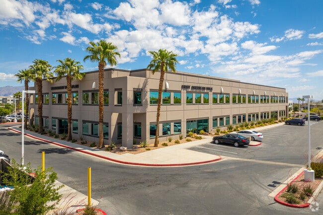
2500 N Buffalo Dr
Las Vegas-Henderson-Paradise, NV
Las Vegas Technology Center Resub
138-15-410-023
LAS VEGAS TECHNOLOGY CENTER RESUB PLAT BOOK 47 PAGE 35 PT LOT 1 BLOCK 5
Commercialnec
Clark
X
Nevada
32003C2135F
1
2025
6.20 AC
2025
Northwest Las Vegas
003415
Las Vegas
88,673 SF
DEMOGRAPHICS near 2500 N Buffalo Dr
1 Mile
3 Mile
5 Mile
2024 Total Population
18,479
182,966
407,669
2029 Population
19,845
196,131
436,972
Pop Growth 2024-2029
+ 7.39%
+ 7.20%
+ 7.19%
Average Age
40
41
41
2024 Total Households
7,903
70,443
156,909
HH Growth 2024-2029
+ 7.45%
+ 7.19%
+ 7.19%
Median Household Inc
$61,841
$58,086
$62,518
Avg Household Size
2.30
2.50
2.50
2024 Avg HH Vehicles
2.00
2.00
2.00
Median Home Value
$384,944
$332,617
$360,855
Median Year Built
1992
1991
1992
Nearby Places
Map Layers
Map Styles
 Street
 Aerial
- Restaurants
- Banks
- Shops
- Fitness
- Groceries
PUBLIC TRANSPORTATION
AIRPORT
Harry Reid International
DRIVE
WALK
Distance
Harry Reid International
26 min
14.9 mi
Boulder City Municipal
DRIVE
WALK
Distance
Boulder City Municipal
46 min
34.9 mi
Nearby Properties
Address
Land Use
TOTAL SIZE
Lot Size
Zoning
Address
Land Use
TOTAL SIZE
Lot Size
Zoning
336,142 SF
39.99 AC
PC
Address
Land Use
TOTAL SIZE
Lot Size
Zoning
161.14 AC
CV
Address
Land Use
TOTAL SIZE
Lot Size
Zoning
157.50 AC
Address
Land Use
TOTAL SIZE
Lot Size
Zoning
5,643 SF
10.29 AC
Address
Land Use
TOTAL SIZE
Lot Size
Zoning
37.31 AC
CV
Address
Land Use
TOTAL SIZE
Lot Size
Zoning
7,148 SF
7.26 AC
Address
Land Use
TOTAL SIZE
Lot Size
Zoning
14,793 SF
9.57 AC
CPB
Address
Land Use
TOTAL SIZE
Lot Size
Zoning
5,057 SF
9.46 AC
RE
Address
Land Use
TOTAL SIZE
Lot Size
Zoning
263,881 SF
7.49 AC
R-4
Address
Land Use
TOTAL SIZE
Lot Size
Zoning
5,750 SF
19.67 AC
R3
Address
Land Use
TOTAL SIZE
Lot Size
Zoning
21.12 AC
RE
Address
Land Use
TOTAL SIZE
Lot Size
Zoning
4,084 SF
1.84 AC
CPB
Address
Land Use
TOTAL SIZE
Lot Size
Zoning
52,058 SF
6.44 AC
C1
Address
Land Use
TOTAL SIZE
Lot Size
Zoning
285,929 SF
5.06 AC
C1
Address
Land Use
TOTAL SIZE
Lot Size
Zoning
211,331 SF
6.70 AC
USC
Address
Land Use
TOTAL SIZE
Lot Size
Zoning
6,280 SF
8.72 AC
RPD18
Address
Land Use
TOTAL SIZE
Lot Size
Zoning
3,618 SF
10 AC
L:R-3
Address
Land Use
TOTAL SIZE
Lot Size
Zoning
7,103 SF
14.27 AC
L:R-3
Address
Land Use
TOTAL SIZE
Lot Size
Zoning
99,487 SF
22.61 AC
PC
Address
Land Use
TOTAL SIZE
Lot Size
Zoning
7,148 SF
15.33 AC
L:R-PD20
Address
Land Use
TOTAL SIZE
Lot Size
Zoning
1,838 SF
24.69 AC
R3
Address
Land Use
TOTAL SIZE
Lot Size
Zoning
18.02 AC
PF
Address
Land Use
TOTAL SIZE
Lot Size
Zoning
2,006 SF
13.79 AC
RPD20
Address
Land Use
TOTAL SIZE
Lot Size
Zoning
4,978 SF
15.05 AC
R3
Address
Land Use
TOTAL SIZE
Lot Size
Zoning
5,171 SF
4.24 AC
RPD14
Address
Land Use
TOTAL SIZE
Lot Size
Zoning
267,271 SF
22.36 AC
C1
Address
Land Use
TOTAL SIZE
Lot Size
Zoning
6,020 SF
10.30 AC
PC
Address
Land Use
TOTAL SIZE
Lot Size
Zoning
9,789 SF
2.10 AC
R3
Address
Land Use
TOTAL SIZE
Lot Size
Zoning
7,427 SF
4.56 AC
R3
The World's #1 Commercial Real Estate Marketplace
Connect with us
© 2025 CoStar Group
The information above has been obtained from sources believed reliable. While we do not doubt its accuracy we have not verified it and make no guarantee, warranty or representation about it. It is your responsibility to independently confirm its accuracy and completeness. Any projections, opinions, assumptions, or estimates used are for example only and do not represent the current or future performance of the property. The value of this transaction to you depends on tax and other factors which should be evaluated by your tax, financial, and legal advisors. You and your advisors should conduct a careful, independent investigation of the property to determine to your satisfaction the suitability of the property for your needs.