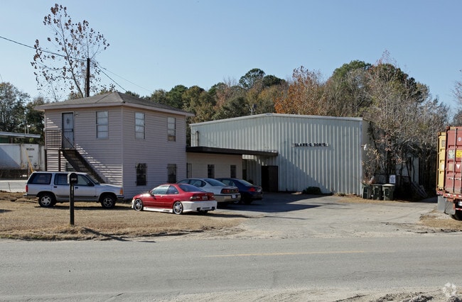
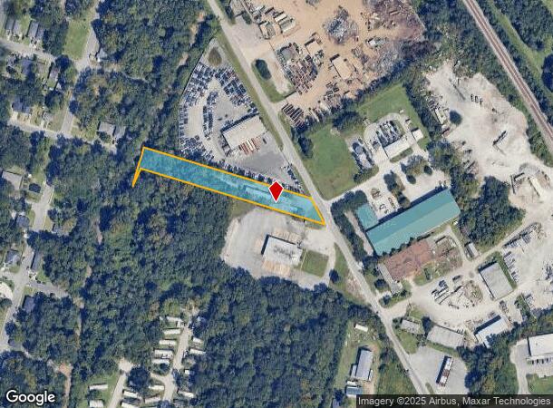
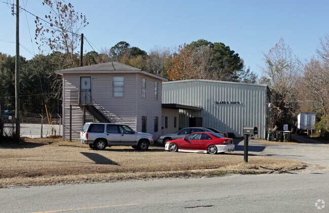
Property Record
2819 Tremont Rd, Savannah, GA 31405
NEARBY LISTINGS FOR SALE OR LEASE
Property Detail
2819 Tremont Rd
2063716012A
PORTION OF SHORE PROPERTY TREMON T RD TYLER TCT
Manufacturinglight
Chatham
AE
Georgia
13051C0142G
1.64 AC
2024
Greater Savannah
2025
Savannah
004500
Savannah, GA
600 SF
DEMOGRAPHICS near 2819 Tremont Rd
1 Mile
3 Mile
5 Mile
2024 Total Population
4,354
68,013
132,578
2029 Population
4,522
71,604
138,540
Pop Growth 2024-2029
+ 3.86%
+ 5.28%
+ 4.50%
Average Age
43
37
38
2024 Total Households
1,671
27,656
54,093
HH Growth 2024-2029
+ 3.83%
+ 5.71%
+ 4.81%
Median Household Inc
$41,781
$47,218
$48,135
Avg Household Size
2.50
2.20
2.20
2024 Avg HH Vehicles
2.00
1.00
1.00
Median Home Value
$158,643
$258,698
$185,886
Median Year Built
1968
1959
1965
Nearby Places
Map Layers
Map Styles
 Street
 Aerial
- Restaurants
- Banks
- Shops
- Fitness
- Groceries
PUBLIC TRANSPORTATION
COMMUTER RAIL
Savannah (Palmetto - Amtrak, Silver Meteor - Amtrak, Silver Star - Amtrak)
DRIVE
WALK
Distance
Savannah (Palmetto - Amtrak, Silver Meteor - Amtrak, Silver Star - Amtrak)
6 min
2.3 mi
AIRPORT
Savannah/Hilton Head International
DRIVE
WALK
Distance
Savannah/Hilton Head International
18 min
9.7 mi
Hilton Head
DRIVE
WALK
Distance
Hilton Head
62 min
39.7 mi
Freight Ports
Georgia Ports - Savannah
DRIVE
WALK
Distance
Georgia Ports - Savannah
11 min
5.7 mi
Nearby Properties
Address
Land Use
TOTAL SIZE
Lot Size
Zoning
Address
Land Use
TOTAL SIZE
Lot Size
Zoning
1,400 SF
6.97 AC
D-X
Address
Land Use
TOTAL SIZE
Lot Size
Zoning
0.12 AC
R6
Address
Land Use
TOTAL SIZE
Lot Size
Zoning
31,396 SF
1.69 AC
BG
Address
Land Use
TOTAL SIZE
Lot Size
Zoning
86,336 SF
1.08 AC
BB
Address
Land Use
TOTAL SIZE
Lot Size
Zoning
489,483 SF
35 AC
PUDB
Address
Land Use
TOTAL SIZE
Lot Size
Zoning
4,930 SF
1.18 AC
I-L
Address
Land Use
TOTAL SIZE
Lot Size
Zoning
351,297 SF
2.08 AC
BC1
Address
Land Use
TOTAL SIZE
Lot Size
Zoning
124,080 SF
1.66 AC
BB
Address
Land Use
TOTAL SIZE
Lot Size
Zoning
173,554 SF
0.72 AC
BB
Address
Land Use
TOTAL SIZE
Lot Size
Zoning
34,224 SF
20 AC
C-1
Address
Land Use
TOTAL SIZE
Lot Size
Zoning
33,000 SF
1.92 AC
I-L
Address
Land Use
TOTAL SIZE
Lot Size
Zoning
199,424 SF
2.49 AC
BN
Address
Land Use
TOTAL SIZE
Lot Size
Zoning
116,928 SF
1.10 AC
BB
Address
Land Use
TOTAL SIZE
Lot Size
Zoning
84,560 SF
0.31 AC
BC1
Address
Land Use
TOTAL SIZE
Lot Size
Zoning
479,600 SF
28.24 AC
IH
Address
Land Use
TOTAL SIZE
Lot Size
Zoning
21,316 SF
26.07 AC
PUDM18
Address
Land Use
TOTAL SIZE
Lot Size
Zoning
77,610 SF
0.33 AC
BC1
Address
Land Use
TOTAL SIZE
Lot Size
Zoning
245,610 SF
1.10 AC
RIPC
Address
Land Use
TOTAL SIZE
Lot Size
Zoning
32,190 SF
22.11 AC
PUDBR
Address
Land Use
TOTAL SIZE
Lot Size
Zoning
29,304 SF
27.20 AC
R3
Address
Land Use
TOTAL SIZE
Lot Size
Zoning
115,069 SF
1.14 AC
BC1
Address
Land Use
TOTAL SIZE
Lot Size
Zoning
33,432 SF
16.38 AC
PUDB
Address
Land Use
TOTAL SIZE
Lot Size
Zoning
1.07 AC
BG
Address
Land Use
TOTAL SIZE
Lot Size
Zoning
810 SF
20 AC
Address
Land Use
TOTAL SIZE
Lot Size
Zoning
384,000 SF
48.45 AC
I-H
Address
Land Use
TOTAL SIZE
Lot Size
Zoning
400,000 SF
1.12 AC
I-L
Address
Land Use
TOTAL SIZE
Lot Size
Zoning
0.49 AC
BC1
Address
Land Use
TOTAL SIZE
Lot Size
Zoning
251,630 SF
20.78 AC
M
Address
Land Use
TOTAL SIZE
Lot Size
Zoning
7,900 SF
1.98 AC
RIPB1
Address
Land Use
TOTAL SIZE
Lot Size
Zoning
60,911 SF
0.17 AC
BB
The World's #1 Commercial Real Estate Marketplace
Connect with us
© 2025 CoStar Group
The information above has been obtained from sources believed reliable. While we do not doubt its accuracy we have not verified it and make no guarantee, warranty or representation about it. It is your responsibility to independently confirm its accuracy and completeness. Any projections, opinions, assumptions, or estimates used are for example only and do not represent the current or future performance of the property. The value of this transaction to you depends on tax and other factors which should be evaluated by your tax, financial, and legal advisors. You and your advisors should conduct a careful, independent investigation of the property to determine to your satisfaction the suitability of the property for your needs.