Property Record
2824 Milam Rd E, Sanger, TX 76266
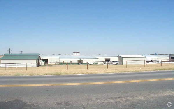


Property Detail
2824 Milam Rd E
R173312
A0002A J. AYERS, TR 50D(2)(PT), 7.1720 ACRES,
Commercialacreage
Denton
B and X Area of moderate flood hazard, usually the area between the limits of the 100-year and 500-year floods.
Texas
2024
7.17 AC
2025
Denton
020404
Dallas/Ft Worth
22,600 SF
Dallas-Fort Worth-Arlington, TX
NEARBY LISTINGS FOR SALE OR LEASE
DEMOGRAPHICS near 2824 Milam Rd E
1 mile
3 mile
5 mile
2025 Total Population
164
2,004
46,746
2030 Population
187
2,324
53,284
Pop Growth 2025-2030
+ 14.02%
+ 15.97%
+ 13.99%
Average Age
37
39
38
2025 Total Households
66
670
17,521
HH Growth 2025-2030
+ 15.15%
+ 16.12%
+ 14.17%
Median Household Inc
$86,458
$116,764
$89,157
Avg Household Size
2.40
2.90
2.60
2025 Avg HH Vehicles
2.00
2.00
2.00
Median Home Value
$373,333
$566,754
$327,064
Median Year Built
2010
2010
1997
Nearby Places
Map Layers
Map Styles
 Street
 Aerial
Transit
 Traffic
 Biking
Places
Listings with unknown addresses are not visible on the map
- Restaurants
- Banks
- Shops
- Fitness
- Groceries
PUBLIC TRANSPORTATION
COMMUTER RAIL
Downtown Denton Transit Center (A-train - Denton County Transportation Authority)
Drive
Walk
Distance
Downtown Denton Transit Center (A-train - Denton County Transportation Authority)
13 min
7.9 mi
AIRPORT
Dallas-Fort Worth International
Drive
Walk
Distance
Dallas-Fort Worth International
41 min
34.1 mi
Freight Ports
Tulsa Port of Inola
Drive
Walk
Distance
Tulsa Port of Inola
301 min
266.5 mi
Nearby Properties
Address
Land Use
TOTAL SIZE
Lot Size
Zoning
Address
Land Use
TOTAL SIZE
Lot Size
Zoning
702,810 SF
37.91 AC
Address
Land Use
TOTAL SIZE
Lot Size
Zoning
374,520 SF
23.62 AC
Address
Land Use
TOTAL SIZE
Lot Size
Zoning
367,488 SF
22.80 AC
Address
Land Use
TOTAL SIZE
Lot Size
Zoning
247,171 SF
20.30 AC
Address
Land Use
TOTAL SIZE
Lot Size
Zoning
166,705 SF
6.21 AC
Address
Land Use
TOTAL SIZE
Lot Size
Zoning
66,330 SF
30 AC
Address
Land Use
TOTAL SIZE
Lot Size
Zoning
123,830 SF
12.26 AC
Address
Land Use
TOTAL SIZE
Lot Size
Zoning
1,094 SF
104.42 AC
Address
Land Use
TOTAL SIZE
Lot Size
Zoning
75.95 AC
Address
Land Use
TOTAL SIZE
Lot Size
Zoning
102.50 AC
Address
Land Use
TOTAL SIZE
Lot Size
Zoning
18,198 SF
16.98 AC
Address
Land Use
TOTAL SIZE
Lot Size
Zoning
66.67 AC
Address
Land Use
TOTAL SIZE
Lot Size
Zoning
38,004 SF
7.51 AC
Address
Land Use
TOTAL SIZE
Lot Size
Zoning
1,153,213 SF
81.58 AC
Address
Land Use
TOTAL SIZE
Lot Size
Zoning
45.51 AC
Address
Land Use
TOTAL SIZE
Lot Size
Zoning
48,977 SF
33.20 AC
Address
Land Use
TOTAL SIZE
Lot Size
Zoning
29,411 SF
17.89 AC
Address
Land Use
TOTAL SIZE
Lot Size
Zoning
71,906 SF
69.06 AC
Address
Land Use
TOTAL SIZE
Lot Size
Zoning
63.99 AC
Address
Land Use
TOTAL SIZE
Lot Size
Zoning
56,901 SF
3.97 AC
Address
Land Use
TOTAL SIZE
Lot Size
Zoning
90,800 SF
4.45 AC
Address
Land Use
TOTAL SIZE
Lot Size
Zoning
15,230 SF
40 AC
Address
Land Use
TOTAL SIZE
Lot Size
Zoning
1,217 SF
31.24 AC
Address
Land Use
TOTAL SIZE
Lot Size
Zoning
14,528 SF
9.39 AC
Address
Land Use
TOTAL SIZE
Lot Size
Zoning
2,475 SF
112.83 AC
Address
Land Use
TOTAL SIZE
Lot Size
Zoning
20,520 SF
4.36 AC
Address
Land Use
TOTAL SIZE
Lot Size
Zoning
3,050 SF
42.34 AC
Address
Land Use
TOTAL SIZE
Lot Size
Zoning
118.85 AC
Address
Land Use
TOTAL SIZE
Lot Size
Zoning
8,011 SF
247.32 AC
Address
Land Use
TOTAL SIZE
Lot Size
Zoning
23.88 AC
The World's #1 Commercial Real Estate Marketplace
Connect with us
© 2026 CoStar Group
The information above has been obtained from sources believed reliable. While we do not doubt its accuracy we have not verified it and make no guarantee, warranty or representation about it. It is your responsibility to independently confirm its accuracy and completeness. Any projections, opinions, assumptions, or estimates used are for example only and do not represent the current or future performance of the property. The value of this transaction to you depends on tax and other factors which should be evaluated by your tax, financial, and legal advisors. You and your advisors should conduct a careful, independent investigation of the property to determine to your satisfaction the suitability of the property for your needs.