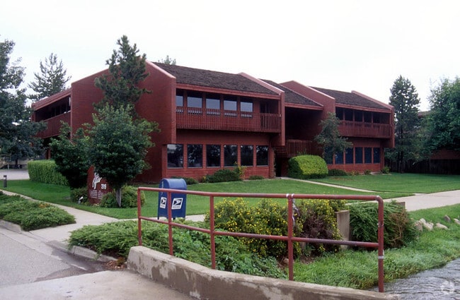
Property Record
2919 Valmont Rd, Boulder, CO 80301

Current Lease Availabilities
Property Detail
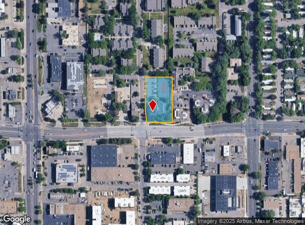
2919 Valmont Rd
Boulder, CO
2919 Valmont Road - Bo
1463203-18-001
LOT 1 2919 VALMONT ROAD
Storesoffices
Boulder
X
Colorado
08013C0394K
1
2024
0.99 AC
2025
Boulder
012208
Denver
12,474 SF
NEARBY LISTINGS FOR SALE OR LEASE
DEMOGRAPHICS near 2919 Valmont Rd
1 mile
3 mile
5 mile
2024 Total Population
17,519
96,755
124,492
2029 Population
17,554
96,903
124,241
Pop Growth 2024-2029
+ 0.20%
+ 0.15%
(0.20%)
Average Age
39
37
38
2024 Total Households
8,566
38,491
50,645
HH Growth 2024-2029
+ 0.32%
+ 0.24%
(0.19%)
Median Household Inc
$72,488
$71,746
$84,433
Avg Household Size
1.90
2.10
2.10
2024 Avg HH Vehicles
1.00
2.00
2.00
Median Home Value
$805,820
$1,010,147
$1,005,044
Median Year Built
1982
1979
1978
Nearby Places
Map Layers
Map Styles
 Street
 Aerial
Transit
 Traffic
 Biking
Places
Listings with unknown addresses are not visible on the map
- Restaurants
- Banks
- Shops
- Fitness
- Groceries
PUBLIC TRANSPORTATION
AIRPORT
Denver International
Drive
Walk
Distance
Denver International
53 min
44.0 mi
Nearby Properties
Address
Land Use
TOTAL SIZE
Lot Size
Zoning
Address
Land Use
TOTAL SIZE
Lot Size
Zoning
1,285,025 SF
17.46 AC
Address
Land Use
TOTAL SIZE
Lot Size
Zoning
30.08 AC
Address
Land Use
TOTAL SIZE
Lot Size
Zoning
14.66 AC
Address
Land Use
TOTAL SIZE
Lot Size
Zoning
171.91 AC
Address
Land Use
TOTAL SIZE
Lot Size
Zoning
1,892,750 SF
200 AC
Address
Land Use
TOTAL SIZE
Lot Size
Zoning
941,000 SF
44 SF
Address
Land Use
TOTAL SIZE
Lot Size
Zoning
155,000 SF
205.33 AC
Address
Land Use
TOTAL SIZE
Lot Size
Zoning
329,080 SF
16.41 AC
Address
Land Use
TOTAL SIZE
Lot Size
Zoning
244,999 SF
2.24 AC
Address
Land Use
TOTAL SIZE
Lot Size
Zoning
599,605 SF
4.46 AC
Address
Land Use
TOTAL SIZE
Lot Size
Zoning
842,665 SF
59.42 AC
Address
Land Use
TOTAL SIZE
Lot Size
Zoning
196,542 SF
1.41 AC
Address
Land Use
TOTAL SIZE
Lot Size
Zoning
191,430 SF
5.92 AC
Address
Land Use
TOTAL SIZE
Lot Size
Zoning
204,396 SF
1.41 AC
Address
Land Use
TOTAL SIZE
Lot Size
Zoning
385,761 SF
19.07 AC
Address
Land Use
TOTAL SIZE
Lot Size
Zoning
161,616 SF
8 AC
Address
Land Use
TOTAL SIZE
Lot Size
Zoning
294,015 SF
2.05 AC
Address
Land Use
TOTAL SIZE
Lot Size
Zoning
518,974 SF
65.71 AC
Address
Land Use
TOTAL SIZE
Lot Size
Zoning
234,968 SF
0.96 AC
Address
Land Use
TOTAL SIZE
Lot Size
Zoning
25.41 AC
GI
Address
Land Use
TOTAL SIZE
Lot Size
Zoning
38.79 AC
RR
Address
Land Use
TOTAL SIZE
Lot Size
Zoning
48.98 AC
A
Address
Land Use
TOTAL SIZE
Lot Size
Zoning
117,540 SF
Address
Land Use
TOTAL SIZE
Lot Size
Zoning
161,761 SF
4.79 AC
Address
Land Use
TOTAL SIZE
Lot Size
Zoning
276,166 SF
2.98 AC
Address
Land Use
TOTAL SIZE
Lot Size
Zoning
173,205 SF
3.35 AC
Address
Land Use
TOTAL SIZE
Lot Size
Zoning
161,711 SF
20.40 AC
MH
Address
Land Use
TOTAL SIZE
Lot Size
Zoning
159,270 SF
9.52 AC
Address
Land Use
TOTAL SIZE
Lot Size
Zoning
107.31 AC
A
Address
Land Use
TOTAL SIZE
Lot Size
Zoning
27.92 AC
RR
The World's #1 Commercial Real Estate Marketplace
Connect with us
© 2026 CoStar Group
The information above has been obtained from sources believed reliable. While we do not doubt its accuracy we have not verified it and make no guarantee, warranty or representation about it. It is your responsibility to independently confirm its accuracy and completeness. Any projections, opinions, assumptions, or estimates used are for example only and do not represent the current or future performance of the property. The value of this transaction to you depends on tax and other factors which should be evaluated by your tax, financial, and legal advisors. You and your advisors should conduct a careful, independent investigation of the property to determine to your satisfaction the suitability of the property for your needs.