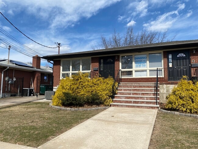
Property Record
299 Guyon Ave, Staten Island, NY 10306


Save to a Folder
{{folder.Name}}
{{folder.ListingIds.length}} Properties
{{folder.ListingIds.length}} Property
Create a New Folder
Property Detail
299 Guyon Ave
04301-0001
Richmond
Funeralhome
New York
R2
1
C and X Area of minimal flood hazard, usually depicted on FIRMs as above the 500-year flood level.
0.26 AC
2025
Staten Island
2026
Long Island (New York)
013201
New York-Jersey City-White Plains, NY-NJ
3,350 SF
NEARBY LISTINGS FOR SALE OR LEASE
DEMOGRAPHICS near 299 Guyon Ave
1 mile
3 mile
5 mile
2025 Total Population
30,460
161,304
384,556
2030 Population
30,702
162,711
387,451
Pop Growth 2025-2030
+ 0.79%
+ 0.87%
+ 0.75%
Average Age
43
43
42
2025 Total Households
11,058
57,675
134,573
HH Growth 2025-2030
+ 0.73%
+ 0.83%
+ 0.73%
Median Household Inc
$99,236
$103,822
$101,254
Avg Household Size
2.70
2.70
2.80
2025 Avg HH Vehicles
2.00
2.00
2.00
Median Home Value
$735,946
$733,447
$729,560
Median Year Built
1967
1973
1973
Nearby Places
Map Layers
Map Styles
 Street
 Aerial
Layers
 Traffic
 Biking
Places
Listings with unknown addresses are not visible on the map
- Restaurants
- Banks
- Shops
- Fitness
- Groceries
PUBLIC TRANSPORTATION
TRANSIT/SUBWAY
Oakwood Heights (Staten Island Railway - New York MTA Subway (The Subway))
Drive
Walk
Distance
Oakwood Heights (Staten Island Railway - New York MTA Subway (The Subway))
2 min
9 min
0.5 mi
COMMUTER RAIL
Oakwood Heights (Staten Island Railway - New York MTA Subway (The Subway))
Drive
Walk
Distance
Oakwood Heights (Staten Island Railway - New York MTA Subway (The Subway))
2 min
9 min
0.5 mi
New Dorp (Staten Island Railway - New York MTA Subway (The Subway))
Drive
Walk
Distance
New Dorp (Staten Island Railway - New York MTA Subway (The Subway))
4 min
1.2 mi
AIRPORT
Newark Liberty International
Drive
Walk
Distance
Newark Liberty International
32 min
17.1 mi
LaGuardia
Drive
Walk
Distance
LaGuardia
42 min
24.0 mi
John F Kennedy International
Drive
Walk
Distance
John F Kennedy International
42 min
26.6 mi
Freight Ports
New York Container Terminal
Drive
Walk
Distance
New York Container Terminal
18 min
7.8 mi
SALE & LEASE HISTORY
LISTING DATE
SALE/LEASE

Sep 06, 2023
For Lease
Mar 26, 2025
For Lease
Nearby Properties
Address
Land Use
TOTAL SIZE
Lot Size
Zoning
Address
Land Use
TOTAL SIZE
Lot Size
Zoning
3,600 SF
731.18 AC
PARK
Address
Land Use
TOTAL SIZE
Lot Size
Zoning
738,600 SF
189.62 AC
R3-2
Address
Land Use
TOTAL SIZE
Lot Size
Zoning
1,258,042 SF
14.47 AC
C4-1
Address
Land Use
TOTAL SIZE
Lot Size
Zoning
640,077 SF
19.34 AC
R3-1
Address
Land Use
TOTAL SIZE
Lot Size
Zoning
566,000 SF
103.31 AC
R3-2
Address
Land Use
TOTAL SIZE
Lot Size
Zoning
135,000 SF
117.71 AC
PARK
Address
Land Use
TOTAL SIZE
Lot Size
Zoning
310,560 SF
15.90 AC
C4-1
Address
Land Use
TOTAL SIZE
Lot Size
Zoning
494,840 SF
34.77 AC
R3-2
Address
Land Use
TOTAL SIZE
Lot Size
Zoning
195,395 SF
12.04 AC
R3-2
Address
Land Use
TOTAL SIZE
Lot Size
Zoning
418,012 SF
6.74 AC
R3-1
Address
Land Use
TOTAL SIZE
Lot Size
Zoning
421,275 SF
18.95 AC
R3-2
Address
Land Use
TOTAL SIZE
Lot Size
Zoning
294,320 SF
15 AC
R3-2
Address
Land Use
TOTAL SIZE
Lot Size
Zoning
505,000 SF
3.79 AC
R3A
Address
Land Use
TOTAL SIZE
Lot Size
Zoning
476,145 SF
50.97 AC
R3-1
Address
Land Use
TOTAL SIZE
Lot Size
Zoning
48,500 SF
61.98 AC
R3-2
Address
Land Use
TOTAL SIZE
Lot Size
Zoning
377,678 SF
25.40 AC
C4-1
Address
Land Use
TOTAL SIZE
Lot Size
Zoning
77,502 SF
1.29 AC
R3-1
Address
Land Use
TOTAL SIZE
Lot Size
Zoning
900 SF
50 AC
R1-1
Address
Land Use
TOTAL SIZE
Lot Size
Zoning
319,000 SF
18.76 AC
C4-1
Address
Land Use
TOTAL SIZE
Lot Size
Zoning
151,637 SF
7.41 AC
C4-1
Address
Land Use
TOTAL SIZE
Lot Size
Zoning
45,570 SF
206.38 AC
PARKUS
Address
Land Use
TOTAL SIZE
Lot Size
Zoning
7,410 SF
44.60 AC
R1-1
Address
Land Use
TOTAL SIZE
Lot Size
Zoning
26.45 AC
PARK
Address
Land Use
TOTAL SIZE
Lot Size
Zoning
180,000 SF
2.28 AC
R2
Address
Land Use
TOTAL SIZE
Lot Size
Zoning
126,000 SF
6.36 AC
R3-2
Address
Land Use
TOTAL SIZE
Lot Size
Zoning
146,568 SF
26.40 AC
R3-1
Address
Land Use
TOTAL SIZE
Lot Size
Zoning
12,400 SF
47.97 AC
R3-2
Address
Land Use
TOTAL SIZE
Lot Size
Zoning
21.58 AC
PARK
Address
Land Use
TOTAL SIZE
Lot Size
Zoning
24,000 SF
7.46 AC
C8-1
Address
Land Use
TOTAL SIZE
Lot Size
Zoning
3,000 SF
40 AC
R3-2
The World's #1 Commercial Real Estate Marketplace
Connect with us
© 2026 CoStar Group
The information above has been obtained from sources believed reliable. While we do not doubt its accuracy we have not verified it and make no guarantee, warranty or representation about it. It is your responsibility to independently confirm its accuracy and completeness. Any projections, opinions, assumptions, or estimates used are for example only and do not represent the current or future performance of the property. The value of this transaction to you depends on tax and other factors which should be evaluated by your tax, financial, and legal advisors. You and your advisors should conduct a careful, independent investigation of the property to determine to your satisfaction the suitability of the property for your needs.