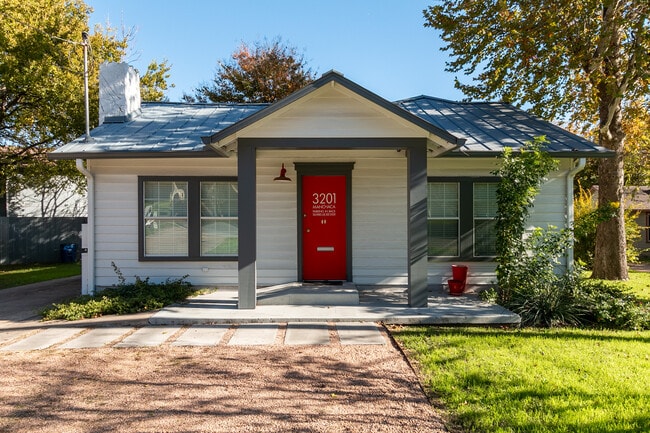
Property Record
3201 Menchaca Rd, Austin, TX 78704

Property Detail
3201 Menchaca Rd
Austin-Round Rock-San Marcos, TX
TRT 2 *LESS W 5.8 FT AV FOSTER A R SUBD
305423
Travis
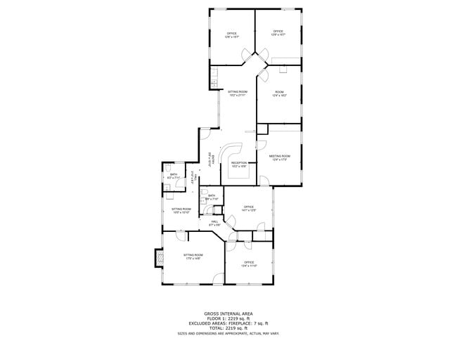
Officebuilding
Texas
AE The base floodplain where base flood elevations are provided. AE Zones are now used on new format FIRMs instead of A1-A30 Zones.
2
2025
0.42 AC
2025
South
002007
Austin
2,336 SF
NEARBY LISTINGS FOR SALE OR LEASE
DEMOGRAPHICS near 3201 Menchaca Rd
1 mile
3 mile
5 mile
2025 Total Population
18,240
128,098
364,141
2030 Population
19,146
134,531
381,678
Pop Growth 2025-2030
+ 4.97%
+ 5.02%
+ 4.82%
Average Age
37
39
36
2025 Total Households
10,041
65,711
164,690
HH Growth 2025-2030
+ 5.57%
+ 5.71%
+ 5.69%
Median Household Inc
$87,574
$106,905
$90,514
Avg Household Size
1.80
1.90
2.00
2025 Avg HH Vehicles
1.00
2.00
2.00
Median Home Value
$824,359
$814,632
$716,550
Median Year Built
1988
1994
1995
Nearby Places
Map Layers
Map Styles
 Street
 Aerial
Transit
 Traffic
 Biking
Places
Listings with unknown addresses are not visible on the map
- Restaurants
- Banks
- Shops
- Fitness
- Groceries
PUBLIC TRANSPORTATION
AIRPORT
Austin-Bergstrom International
Drive
Walk
Distance
Austin-Bergstrom International
23 min
11.2 mi
SALE & LEASE HISTORY
LISTING DATE
SALE/LEASE

May 23, 2024
For Sale
May 03, 2018
For Sale
Jul 14, 2020
For Sale
Jul 11, 2017
For Sale
Dec 19, 2024
For Lease
Dec 08, 2023
For Sale
Nearby Properties
Address
Land Use
TOTAL SIZE
Lot Size
Zoning
Address
Land Use
TOTAL SIZE
Lot Size
Zoning
20,550 SF
14.15 AC
Address
Land Use
TOTAL SIZE
Lot Size
Zoning
262 SF
65.06 AC
Address
Land Use
TOTAL SIZE
Lot Size
Zoning
1,003,475 SF
1.84 AC
Address
Land Use
TOTAL SIZE
Lot Size
Zoning
786,600 SF
1.27 AC
Address
Land Use
TOTAL SIZE
Lot Size
Zoning
9,034 SF
28.69 AC
Address
Land Use
TOTAL SIZE
Lot Size
Zoning
709,300 SF
0.94 AC
Address
Land Use
TOTAL SIZE
Lot Size
Zoning
498,684 SF
61.86 AC
Address
Land Use
TOTAL SIZE
Lot Size
Zoning
47.20 AC
Address
Land Use
TOTAL SIZE
Lot Size
Zoning
1,400,000 SF
3.07 AC
Address
Land Use
TOTAL SIZE
Lot Size
Zoning
35,041 SF
28.65 AC
Address
Land Use
TOTAL SIZE
Lot Size
Zoning
513,567 SF
1.78 AC
Address
Land Use
TOTAL SIZE
Lot Size
Zoning
500,511 SF
0.82 AC
Address
Land Use
TOTAL SIZE
Lot Size
Zoning
24.06 AC
Address
Land Use
TOTAL SIZE
Lot Size
Zoning
826,478 SF
1.75 AC
Address
Land Use
TOTAL SIZE
Lot Size
Zoning
341,096 SF
0.31 AC
Address
Land Use
TOTAL SIZE
Lot Size
Zoning
546,000 SF
1.27 AC
Address
Land Use
TOTAL SIZE
Lot Size
Zoning
533,917 SF
0.81 AC
Address
Land Use
TOTAL SIZE
Lot Size
Zoning
597,500 SF
0.99 AC
Address
Land Use
TOTAL SIZE
Lot Size
Zoning
337,855 SF
43.51 AC
Address
Land Use
TOTAL SIZE
Lot Size
Zoning
400,000 SF
0.27 AC
Address
Land Use
TOTAL SIZE
Lot Size
Zoning
Address
Land Use
TOTAL SIZE
Lot Size
Zoning
6.12 AC
Address
Land Use
TOTAL SIZE
Lot Size
Zoning
483,917 SF
1.60 AC
Address
Land Use
TOTAL SIZE
Lot Size
Zoning
27.45 AC
Address
Land Use
TOTAL SIZE
Lot Size
Zoning
627,984 SF
0.81 AC
Address
Land Use
TOTAL SIZE
Lot Size
Zoning
219,543 SF
0.22 AC
Address
Land Use
TOTAL SIZE
Lot Size
Zoning
357,080 SF
0.41 AC
Address
Land Use
TOTAL SIZE
Lot Size
Zoning
364,532 SF
0.41 AC
Address
Land Use
TOTAL SIZE
Lot Size
Zoning
347,587 SF
0.41 AC
Address
Land Use
TOTAL SIZE
Lot Size
Zoning
397,281 SF
0.93 AC
The World's #1 Commercial Real Estate Marketplace
Connect with us
© 2026 CoStar Group
The information above has been obtained from sources believed reliable. While we do not doubt its accuracy we have not verified it and make no guarantee, warranty or representation about it. It is your responsibility to independently confirm its accuracy and completeness. Any projections, opinions, assumptions, or estimates used are for example only and do not represent the current or future performance of the property. The value of this transaction to you depends on tax and other factors which should be evaluated by your tax, financial, and legal advisors. You and your advisors should conduct a careful, independent investigation of the property to determine to your satisfaction the suitability of the property for your needs.