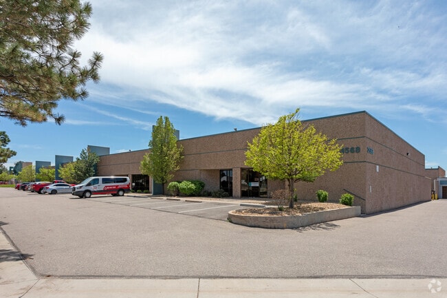
Property Record
3370 Peoria St, Aurora, CO 80010

NEARBY LISTINGS FOR SALE OR LEASE
Property Detail
3370 Peoria St
Denver-Aurora-Centennial, CO
Pacifica Gateway Plaza Filing No 1
1823-25-2-01-017
SUB:PACIFICA GATEWAY PLAZA FILING NO 1 BLK:1 LOT:2 EXC PARC TO CITY OF AURORA (CASE NO 2013CV031186 IN REC NO 2014000026221)
Commercialnec
Adams
X
Colorado
0800460113H
2
2024
7.84 AC
2024
SW DIA/Pena Blvd
008200
Denver
123,607 SF
DEMOGRAPHICS near 3370 Peoria St
1 Mile
3 Mile
5 Mile
2024 Total Population
8,459
136,619
309,005
2029 Population
8,841
138,892
314,081
Pop Growth 2024-2029
+ 4.52%
+ 1.66%
+ 1.64%
Average Age
36
34
36
2024 Total Households
2,512
44,807
110,607
HH Growth 2024-2029
+ 4.54%
+ 1.76%
+ 1.66%
Median Household Inc
$72,886
$68,898
$70,315
Avg Household Size
2.90
2.90
2.70
2024 Avg HH Vehicles
2.00
2.00
2.00
Median Home Value
$362,768
$390,284
$416,871
Median Year Built
1984
1983
1982
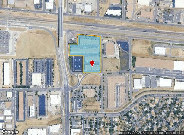
Nearby Places
Map Layers
Map Styles
 Street
 Aerial
- Restaurants
- Banks
- Shops
- Fitness
- Groceries
PUBLIC TRANSPORTATION
COMMUTER RAIL
DRIVE
WALK
Distance
3 min
8 min
0.4 mi
DRIVE
WALK
Distance
3 min
9 min
0.5 mi
AIRPORT
Denver International
DRIVE
WALK
Distance
Denver International
20 min
15.3 mi
SALE & LEASE HISTORY
LISTING DATE
SALE/LEASE

Sep 25, 2016
For Lease
Jul 06, 2018
For Lease
Dec 14, 2017
For Lease
Aug 06, 2020
For Lease
Nearby Properties
Address
Land Use
TOTAL SIZE
Lot Size
Zoning
Address
Land Use
TOTAL SIZE
Lot Size
Zoning
368,450 SF
48.59 AC
Address
Land Use
TOTAL SIZE
Lot Size
Zoning
353,829 SF
4.51 AC
Address
Land Use
TOTAL SIZE
Lot Size
Zoning
719,357 SF
21.47 AC
M-MX-5
Address
Land Use
TOTAL SIZE
Lot Size
Zoning
880,442 SF
67.95 AC
I-B
Address
Land Use
TOTAL SIZE
Lot Size
Zoning
525,050 SF
105.06 AC
Address
Land Use
TOTAL SIZE
Lot Size
Zoning
269,025 SF
18.86 AC
M-RX-5
Address
Land Use
TOTAL SIZE
Lot Size
Zoning
87,346 SF
1.76 AC
RFBAD
Address
Land Use
TOTAL SIZE
Lot Size
Zoning
691,200 SF
38.09 AC
Address
Land Use
TOTAL SIZE
Lot Size
Zoning
335,757 SF
36.88 AC
CMP-EI2
Address
Land Use
TOTAL SIZE
Lot Size
Zoning
273,184 SF
1.89 AC
Address
Land Use
TOTAL SIZE
Lot Size
Zoning
390,822 SF
13.47 AC
O-1
Address
Land Use
TOTAL SIZE
Lot Size
Zoning
57,392 SF
0.72 AC
Address
Land Use
TOTAL SIZE
Lot Size
Zoning
651,423 SF
82.50 AC
I-2
Address
Land Use
TOTAL SIZE
Lot Size
Zoning
185,206 SF
9.94 AC
C-MX
Address
Land Use
TOTAL SIZE
Lot Size
Zoning
646,975 SF
32.60 AC
M-IMX-8
Address
Land Use
TOTAL SIZE
Lot Size
Zoning
37,246 SF
87.83 AC
OS-A
Address
Land Use
TOTAL SIZE
Lot Size
Zoning
33.01 AC
M-IMX-12
Address
Land Use
TOTAL SIZE
Lot Size
Zoning
269,622 SF
12.90 AC
Address
Land Use
TOTAL SIZE
Lot Size
Zoning
723,053 SF
32.44 AC
M-IMX-12
Address
Land Use
TOTAL SIZE
Lot Size
Zoning
124,526 SF
10 AC
M-RH-3
Address
Land Use
TOTAL SIZE
Lot Size
Zoning
677,018 SF
5.05 AC
C-MX
Address
Land Use
TOTAL SIZE
Lot Size
Zoning
178,235 SF
1.38 AC
RFBAD
Address
Land Use
TOTAL SIZE
Lot Size
Zoning
51,075 SF
0.72 AC
Address
Land Use
TOTAL SIZE
Lot Size
Zoning
238,845 SF
1.70 AC
Address
Land Use
TOTAL SIZE
Lot Size
Zoning
624,019 SF
4.09 AC
Address
Land Use
TOTAL SIZE
Lot Size
Zoning
672,521 SF
0.61 AC
RB3
Address
Land Use
TOTAL SIZE
Lot Size
Zoning
400,000 SF
22.91 AC
I-0
Address
Land Use
TOTAL SIZE
Lot Size
Zoning
492,387 SF
50.21 AC
C-MU-30
Address
Land Use
TOTAL SIZE
Lot Size
Zoning
176,751 SF
28.75 AC
Address
Land Use
TOTAL SIZE
Lot Size
Zoning
466,055 SF
24.82 AC
M-IMX-5
The World's #1 Commercial Real Estate Marketplace
Connect with us
© 2026 CoStar Group
The information above has been obtained from sources believed reliable. While we do not doubt its accuracy we have not verified it and make no guarantee, warranty or representation about it. It is your responsibility to independently confirm its accuracy and completeness. Any projections, opinions, assumptions, or estimates used are for example only and do not represent the current or future performance of the property. The value of this transaction to you depends on tax and other factors which should be evaluated by your tax, financial, and legal advisors. You and your advisors should conduct a careful, independent investigation of the property to determine to your satisfaction the suitability of the property for your needs.