Property Record
3449 Chambers Rd, Aurora, CO 80011
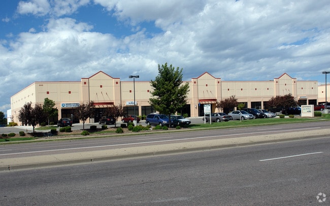
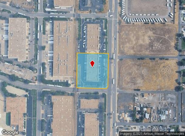
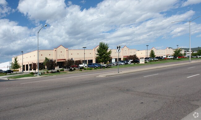
Property Detail
3449 Chambers Rd
Denver-Aurora-Centennial, CO
Commerce Ii Subd Filing No 1
1821-30-1-02-002
SUB:COMMERCE II SUBD FILING NO 1 BLK:1 LOT:1
Miscellaneous
Adams
ARE
Colorado
08005C0043K
1
2024
2.36 AC
2025
SW DIA/Pena Blvd
008308
Denver
28,628 SF
NEARBY LISTINGS FOR SALE OR LEASE
DEMOGRAPHICS near 3449 Chambers Rd
1 mile
3 mile
5 mile
2024 Total Population
7,858
114,890
273,023
2029 Population
8,125
116,954
277,576
Pop Growth 2024-2029
+ 3.40%
+ 1.80%
+ 1.67%
Average Age
35
34
35
2024 Total Households
2,572
35,767
92,318
HH Growth 2024-2029
+ 3.85%
+ 2.00%
+ 1.76%
Median Household Inc
$81,133
$66,678
$69,660
Avg Household Size
2.90
3.00
2.80
2024 Avg HH Vehicles
2.00
2.00
2.00
Median Home Value
$350,395
$354,662
$384,697
Median Year Built
1993
1987
1988
Nearby Places
Map Layers
Map Styles
 Street
 Aerial
Transit
 Traffic
 Biking
Places
Listings with unknown addresses are not visible on the map
- Restaurants
- Banks
- Shops
- Fitness
- Groceries
PUBLIC TRANSPORTATION
COMMUTER RAIL
Drive
Walk
Distance
7 min
2.5 mi
Drive
Walk
Distance
8 min
3.2 mi
AIRPORT
Denver International
Drive
Walk
Distance
Denver International
18 min
13.0 mi
SALE & LEASE HISTORY
LISTING DATE
SALE/LEASE

Aug 04, 2020
For Lease
Nearby Properties
Address
Land Use
TOTAL SIZE
Lot Size
Zoning
Address
Land Use
TOTAL SIZE
Lot Size
Zoning
368,450 SF
48.59 AC
Address
Land Use
TOTAL SIZE
Lot Size
Zoning
353,829 SF
4.51 AC
Address
Land Use
TOTAL SIZE
Lot Size
Zoning
880,442 SF
67.95 AC
I-B
Address
Land Use
TOTAL SIZE
Lot Size
Zoning
244,271 SF
15.30 AC
Address
Land Use
TOTAL SIZE
Lot Size
Zoning
525,050 SF
105.06 AC
Address
Land Use
TOTAL SIZE
Lot Size
Zoning
87,346 SF
1.76 AC
RFBAD
Address
Land Use
TOTAL SIZE
Lot Size
Zoning
868,780 SF
105.02 AC
Address
Land Use
TOTAL SIZE
Lot Size
Zoning
876,549 SF
46.65 AC
Address
Land Use
TOTAL SIZE
Lot Size
Zoning
200,105 SF
34.54 AC
C-MU-20
Address
Land Use
TOTAL SIZE
Lot Size
Zoning
335,757 SF
36.88 AC
CMP-EI2
Address
Land Use
TOTAL SIZE
Lot Size
Zoning
102,444 SF
3.76 AC
GTWY
Address
Land Use
TOTAL SIZE
Lot Size
Zoning
691,200 SF
38.09 AC
Address
Land Use
TOTAL SIZE
Lot Size
Zoning
390,822 SF
13.47 AC
O-1
Address
Land Use
TOTAL SIZE
Lot Size
Zoning
273,184 SF
1.89 AC
Address
Land Use
TOTAL SIZE
Lot Size
Zoning
140.42 AC
Address
Land Use
TOTAL SIZE
Lot Size
Zoning
111,077 SF
3.06 AC
Address
Land Use
TOTAL SIZE
Lot Size
Zoning
550,031 SF
37.73 AC
Address
Land Use
TOTAL SIZE
Lot Size
Zoning
185,812 SF
20.93 AC
C-MU-20
Address
Land Use
TOTAL SIZE
Lot Size
Zoning
512,720 SF
42.32 AC
Address
Land Use
TOTAL SIZE
Lot Size
Zoning
522,120 SF
27.70 AC
Address
Land Use
TOTAL SIZE
Lot Size
Zoning
500,358 SF
23.59 AC
Address
Land Use
TOTAL SIZE
Lot Size
Zoning
548,510 SF
27.26 AC
Address
Land Use
TOTAL SIZE
Lot Size
Zoning
452,400 SF
20.99 AC
Address
Land Use
TOTAL SIZE
Lot Size
Zoning
269,622 SF
12.90 AC
Address
Land Use
TOTAL SIZE
Lot Size
Zoning
419,630 SF
24.34 AC
Address
Land Use
TOTAL SIZE
Lot Size
Zoning
58,997 SF
2.05 AC
S-CC-5X
Address
Land Use
TOTAL SIZE
Lot Size
Zoning
217,995 SF
12.31 AC
S-SU-D
Address
Land Use
TOTAL SIZE
Lot Size
Zoning
400,000 SF
22.91 AC
I-0
Address
Land Use
TOTAL SIZE
Lot Size
Zoning
178,235 SF
1.38 AC
RFBAD
Address
Land Use
TOTAL SIZE
Lot Size
Zoning
92,598 SF
2.78 AC
G-TW
The World's #1 Commercial Real Estate Marketplace
Connect with us
© 2026 CoStar Group
The information above has been obtained from sources believed reliable. While we do not doubt its accuracy we have not verified it and make no guarantee, warranty or representation about it. It is your responsibility to independently confirm its accuracy and completeness. Any projections, opinions, assumptions, or estimates used are for example only and do not represent the current or future performance of the property. The value of this transaction to you depends on tax and other factors which should be evaluated by your tax, financial, and legal advisors. You and your advisors should conduct a careful, independent investigation of the property to determine to your satisfaction the suitability of the property for your needs.